Maps of Dorf Mecklenburg-Bad Kleinen

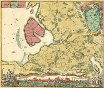
Particulier-Carte der Gegend Von Wismar nebst Der Insul Pöel und angedeuteter Bloquade zu Wasser und Lande 1715
1 : 45000 Mollova mapová sbírka Varenius, Heinrich Homann, Johann Baptista
Accurater Abriss der Stadt und Festung Wismar.
1 : 50000 Mollova mapová sbírka Busch, Georg Paul Riediger, Johann Adam
De Haven En Stad Wismar Desselfs Districkt Belegering En Werken Daer Voor
Mollova mapová sbírka Keulen, Gerard van Anse, Luggert van Keulen, Gerard van
Meßtischblatt 2134 : Wismar, 1919
1 : 250000 Wismar. - Hrsg. 1879. - 1:25000. - [Berlin]: Reichsamt für Landesaufnahme, 1919. - 1 Kt.
Meßtischblatt 2034 : Kirchdorf, 1942
1 : 250000 Kirchdorf. - Aufn. 1877, hrsg. 1879, bericht. 1904, letzte Na. - 1:25000. - [Berlin]: Reichsamt für Landesaufnahme, 1942. - 1 Kt.
Meßtischblatt 665 : Kirchdorf, 1879
1 : 250000 Kirchdorf. - Aufn. 1877, hrsg. 1879. - 1:25000. - [Berlin]: Reichsamt für Landesaufnahme, 1879. - 1 Kt.
Nieuwe Afteekening van de Haven en Stad Wismar met Desselfs Inkoomende zee Gaaten soo Beoosten als Beweste Poel Eyland en beleegering van dito Stad
1 : 65000 Mollova mapová sbírka Keulen, Gerard van Keulen, Gerard van
Composite: 116. Wismar. (Germany)
1 : 100000 Reichsamt fur Landesaufnahme
116. Wismar. (Germany)
1 : 100000 Reichsamt fur Landesaufnahme
Nieuwe affteekening vande haven en stad Wismar met desselfs inkoomende zee gaten soo beoosten als bewesten Poel Eijland
Germany Gerard van Keulen
Meßtischblatt 2135 : Zurow, 1919
1 : 250000 Zurow. - Hrsg. 1879. - 1:25000. - [Berlin]: Reichsamt für Landesaufnahme, 1919. - 1 Kt.
Meßtischblatt 2035 : Neuburg, 1936
1 : 250000 Neuburg. - Hrsg. 1879, einz. Nachtr. 1919. - 1:25000. - [Berlin]: Reichsamt für Landesaufnahme, 1936. - 1 Kt.
Meßtischblatt 581 : Kaltenhof (Insel Poel), 1927
1 : 250000 Kaltenhof (Insel Poel). - Hrsg. 1879, bericht. 1927. - 1:25000. - [Berlin]: Reichsamt für Landesaufnahme, 1927. - 1 Kt.
42. Schwerin i. M., uit: Topographische Uebersichtskarte des Deutschen Reiches / herausgegeben v. d. Kartogr. Abt. d. Königl. Preuß. Landesaufnahme
1 : 200000 titelvariant: Topogr. Übersichtskarte des Deutschen Reiches; Annotatie: Titel boven bladen ook: Topogr. Übersichtskarte des Deutschen Reiches; Annotatie geografische gegevens: Op elk blad twee maatstokken: 10 Kilometer = 5,5 cm; 1 geogr. Meile = 3,6 cm; Legenda onder op elk blad Königlich Preußische Landesaufnahme. Kartographische Abtheilung [S.l : Königlich Preußische Landesaufnahme, Kartographische Abtheilung]
Nieuwe afteekening van een gedeelte van de Belt Zee daer in het in koomen van Wismar en de rivier van Lübeck geleegen aen de kust van Meekelen Burgh
Germany Johannes van Keulen
85. Kropelin. (Germany)
1 : 100000 Reichsamt fur Landesaufnahme
Composite: 85. Kropelin. (Germany)
1 : 100000 Reichsamt fur Landesaufnahme
Meßtischblatt 582 : Russow, 1927
1 : 250000 Russow. - Hrsg. 1879, bericht. 1927. - 1:25000. - [Berlin]: Reichsamt für Landesaufnahme, 1927. - 1 Kt.
Meßtischblatt 2234 : Dambeck, 1881
1 : 250000 Dambeck. - Hrsg. 1879. - 1:25000. - [Berlin]: Reichsamt für Landesaufnahme, 1881. - 1 Kt.
Meßtischblatt 2235 : Hohen- Viecheln, 1881
1 : 250000 Hohen- Viecheln. - Hrsg. 1879. - 1:25000. - [Berlin]: Reichsamt für Landesaufnahme, 1881. - 1 Kt.
Schwerin 34, uit: Special-Karte von Mittel-Europa / nach amtlichen Quellen bearbeitet von W. Liebenow
1 : 300000 titelvariant: W. Liebenow's Mittel-Europa; Annotatie: Titel boven de bladen: W. Liebenow's Mittel-Europa Johannes Wilhelm Liebenow 1822-1897 Frankfurt a. M. : Ludwig Ravenstein

Mappa Ducatus Megalopolitani Nova :
1 : 190000 Mollova mapová sbírka
Mecklenburg-Schwerin, Mecklenburg-Strelitz.
1 : 360000 Weiland, C. F. (Carl Ferdinand), d. 1847

Meklenbvrg Dvcatvs
1 : 520000 Mollova mapová sbírka Lauremberg, Johann Schenk, Peter I
Meklenbvrg Dvcatvs
1 : 520000 Mollova mapová sbírka Lauremberg, Johann Janssonius, Johannes I
Meklenbvrg Dvcatvs
1 : 680000 Mollova mapová sbírka Merian, Matthaeus Merian, Matthäus - dědici
Charte von dem Gross-Herzogthümern Mecklenburg-Schwerin, und Mecklenburg-Strelitz
1 : 359000 Meklenbursko (Německo) Streit, Friedrich Wilhelm Friedrich Campe