Maps of Bergen auf Rügen

Reise Karte von der Insel Rügen
Rujana (Německo) Hagenow, Friedrich von Janssonius, Johannes
Rvgia insvla ac dvcatvs
1 : 270000 Rujana (Německo) Lubin, Eilhard Janssonius, Johannes Ioannis Ianßonius
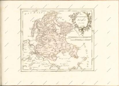
Rügen

Composite: 64. Bergen a. Rugen. (Germany)
1 : 100000 Reichsamt fur Landesaufnahme
64. Bergen a. Rugen. (Germany)
1 : 100000 Reichsamt fur Landesaufnahme
Composite: 42. Sagard. (Germany)
1 : 100000 Reichsamt fur Landesaufnahme
Rugia Insula Ac Ducatus
1 : 240000 Mollova mapová sbírka Lubin, Eilhard Covens, Johannes I
Rugia Insula Ac Ducatus
1 : 265000 Mollova mapová sbírka Lubin, Eilhard Schenk, Peter I
Rugia Insula Ac Ducatus
1 : 240000 Mollova mapová sbírka Lubin, Eilhard Blaeu, Joan I.
Rugia Insula Ac Ducatus
1 : 525000 Mollova mapová sbírka Merian, Matthäus Merian, Matthäus
Rugia Insula Ac Ducatus
1 : 265000 Mollova mapová sbírka Lubin, Eilhard Janssonius, Johannes I
63. Stralsund. (Germany)
1 : 100000 Reichsamt fur Landesaufnahme
Composite: 63. Stralsund. (Germany)
1 : 100000 Reichsamt fur Landesaufnahme
Composite: 41. Wiek auf Rugen. (Germany)
1 : 100000 Reichsamt fur Landesaufnahme
Meßtischblatt 375 : Vilmnitz, 1898
1 : 250000 Vilmnitz. - Aufn. 1885, hrsg. 1887, einz. Nachtr. 1898. - 1:25000. - [Berlin]: Reichsamt für Landesaufnahme, 1898. - 1 Kt.
Meßtischblatt 374 : Putbus, 1886
1 : 250000 Putbus. - Aufn. 1885, hrsg. 1887. - 1:25000. - [Berlin]: Reichsamt für Landesaufnahme, 1886. - 1 Kt.
Meßtischblatt 373, neue Nr. 1645 : Samtens, 1886
1 : 250000 Samtens. - Aufn. 1885, hrsg. 1886. - 1:25000. - [Berlin]: Reichsamt für Landesaufnahme, 1886. - 1 Kt.
Meßtischblatt 316 : Lubkow, 1925
1 : 250000 Lubkow. - Aufn. 1885, bericht. 1925. - 1:25000. - [Berlin]: Reichsamt für Landesaufnahme, 1925. - 1 Kt.
Meßtischblatt 1546 : Bergen (auf Rügen), 1936
1 : 250000 Bergen (auf Rügen). - Hrsg. 1887, bericht. 1925. - 1:25000. - [Berlin]: Reichsamt für Landesaufnahme, 1936. - 1 Kt.
Meßtischblatt 1545 : Gingst, 1936
1 : 250000 Gingst. - Hrsg. 1887, bericht. 1925. - 1:25000. - [Berlin]: Reichsamt für Landesaufnahme, 1936. - 1 Kt.
Meßtischblatt 260, 261 : Sagard, 1920
1 : 250000 Sagard. - Aufn. 1885, Nachtr. 1920. - 1:25000. - [Berlin]: Reichsamt für Landesaufnahme, 1920. - 1 Kt.
Meßtischblatt 259 : Rappin, 1936
1 : 250000 Rappin. - Hrsg. 1886, bericht. 1925. - 1:25000. - [Berlin]: Reichsamt für Landesaufnahme, 1936. - 1 Kt.
Meßtischblatt 258, neue Nr. 1445 : Trent, 1936
1 : 250000 Trent. - Hrsg. 1886, bericht. 1925. - 1:25000. - [Berlin]: Reichsamt für Landesaufnahme, 1936. - 1 Kt.
Meßtischblatt 212 : Wiek, 1933
1 : 250000 Wiek. - Hrsg. 1886, bericht. 1925. - 1:25000. - [Berlin]: Reichsamt für Landesaufnahme, 1933. - 1 Kt.
Meßtischblatt 1346 : Altenkirchen, 1932
1 : 250000 Altenkirchen. - Hrsg. 1886, bericht. 1924, letzte Nachtr. 1932. - 1:25000. - [Berlin]: Reichsamt für Landesaufnahme, 1932. - 1 Kt.
Meßtischblatt 213 : Altenkirchen, 1924
1 : 250000 Altenkirchen. - Hrsg. 1885, bericht. 1924. - 1:25000. - [Berlin]: Reichsamt für Landesaufnahme, 1924. - 1 Kt.
Prospect Grundris und Gegent der königl. schwed. Festung Stralsund
1 : 32000 Stralsund (Německo) Heer, Daniel Homann, Johann Baptist Ioh. Bapt Homann
Plan de la ville de Stralsund, en Pommeranie
Stralsund (Německo) Oebschelwitz, L. W. von Hondt, Pierre de chez Pierre de Hondt