Maps of Antwerp

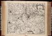
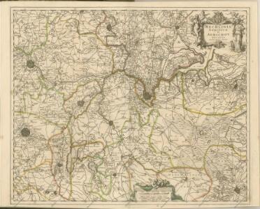
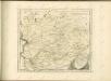
Mechlinia Dominium et Aerschot Ducatus / auctore Nicolao Visscher
1 : 160000 Annotatie: Origineel is Blad 45 in atlas factice; Annotatie geografische gegevens: West boven; Met 2 schaalstokken Nicolaes Jansz Visscher sr 1618-1679 [Amsterdam : Nicolaes Visscher]
Mechlinia Dominium et Aerschot Ducatus [Karte], in: Novus atlas absolutissimus, Bd. 3, S. 197.
1 Karte aus Atlas Janssonius Offizin
MECHLINIA DOMINIUM et AERSCHOT DUCATUS
1 : 160000 Aarschot (Belgie) Visscher, Nicolaus auctore Nicolao Visscher
[120][123] Marchionatus Sacri Imperii et Dominii Mechelini tabula, uit: Atlas sive Descriptio terrarum orbis
Annotatie: Gedigitaliseerde versie. Amsterdam. Heiloo : Picturae (vervaardiger), 2015. tiff-bestand. Gedigitaliseerd: 07-01-2015; Origineel: Universiteitsbibliotheek Vrije Universiteit (XL.05127.-) ; Netherlands; Titelpagina ontbreekt Wit, Frederik de Amsterdam : Frederick de Wit
Tertia Pars Brabantiae qua continetur Marchionat. S.R.I. horum urbs primaria Antverpia [Karte], in: Novus Atlas, das ist, Weltbeschreibung, Bd. 1, S. 322.
1 Karte aus Atlas Blaeu, Joan Blaeu, Willem Janszoon
Tertia Pars Brabantiae qua continetur Marchionats. S.R.I. horum urbs primaria Antverpia [Karte], in: Novus atlas absolutissimus, Bd. 3, S. 50.
1 Karte aus Atlas Janssonius Offizin
Tertia Pars Brabantiae qua continetur Marchionat. S.R.I. horum urbs primaria Antverpia [Karte], in: Le théâtre du monde, ou, Nouvel atlas contenant les chartes et descriptions de tous les païs de la terre, Bd. 1, S. 349.
1 Karte aus Atlas Blaeu, Willem Janszoon und Blaeu, Joan Blaeu, Willem Janszoon
Tertia Pars Brabantiae quae continetur Marchionat. S.R.I. horum urbs primaria Antverpia [Karte], in: Theatrum orbis terrarum, sive, Atlas novus, Bd. 1, S. 343.
1 Karte aus Atlas Blaeu, Joan Blaeu, Willem Janszoon
Tertia pars Brabantiae qua continetur Marchionat. S. R. I. horum urbs primaria Antverpia
1 : 172000 ex archetypo Michaelis Florentii a Langren Guiljelmus Blaeu excudit [Amsterdam] : Blaeu
TERTIA PARS | BRABANTIÆ | qua continetur | MARCHIONAT. S.R.I. | horum urbs primaria | ANTVERPIA
Ex Archetypo | Michaelis Florentij a Langren | Reg. Maj. Mathematico. Guiljelmus Blaeu excudit
Tetrarchiae Antverpiensis pars meridionalis una cum Mechliniensi dominio in ejusdem ditiones subjacentes accuratissime divisa
1 : 130000 Meklenbursko (Německo) Visscher, Nicolaes Jansz. Schenk, Pieter apud Petr Schenk junior
Marchionatus sacri imperii et dominii Mechelini tabula
1 : 115000 auctore F. de Wit. Gedruckt tot Amsterdam : by Frederick de Wit, in de Kalverstraet inde Witte Paskaert
Road and Bridge Map: Antwerp
1 : 100000 First World War Road and Bridge Map. Antwerp. Showing roads normally suitable for motor traffic, road bridges and light railways. War Office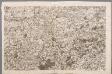
VIII, uit: Carte chorographique des Pays-Bas Autrichiens / ... par le Comte de Ferraris ; gravée par L.A. Dupuis
1 : 86400 Annotatie: Lit.: Les militaires et la cartographie des Pays-Bas méridionaux et de la Principauté de Liège à la fin du XVIIe et au XVIII siècle / Claire Lemoine-Isabeau. - Bruxelles, 1984, p. 206-212; La cartographie au XVIIIe siècle et l'oeuvre du Comte de Ferraris (1726-1814) : colloque international, Spa, 8-11 sept. 1976. - Bruxelles, 1978; Met opdracht aan keizer Joseph II (bl.XVI); Met plattegrond van Brussel (bl. XXI), overzichtskaart (bl. XXII) en bladwijzer (bl. XXIII); Ontbreekt: bl. I-III en XXI; Voor aanwezige bladen zie overzichtsblad Ferraris, Johann Joseph; Dupuis, L. A. [S.l. : s.n.]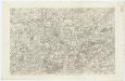
VIII ; 2.K., uit: Carte chorographique des Pays-Bas Autrichiens / ... par le Comte de Ferraris ; gravée par L.A. Dupuis
1 : 86400 Annotatie: Bladen linksboven genummerd met Romeinse cijfers, rechtsboven met een cijfer en een letter; Met opdracht aan keizer Joseph II (bl.XVI); Met plattegrond van Brussel (bl. XXI), overzichtskaart (bl. XXII) en bladwijzer (bl. XXIII); Annotatie geografische gegevens: Schaalstokken: Echelle de Toises ou de Lieues communes de France; Echelle de Verges ou de Lieues de Brabant; Echelle de Milles d'Allemagne (bl. XVII); Echelle de Mètres; In de hoeken lengte- en breedtematen T.M.e en T.P.e Joseph-Jean François Ferraris Comte de 1726-1814; L.A. Dupuis [S.l. : s.n.]
Mechalinia Dominum et Aerschot Ducatus
1 : 266000 Mollova mapová sbírka Visscher, Nicolaes Schenk, Peter II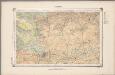
22. Kempen, uit: Geologische kaart van Nederland / door W.C.H. Staring ; bew. aan de Topographische Inrichting
1 : 200000 Winand Carel Hugo Staring 1808-1877; Topographische Inrichting, 's-Gravenhage 's-Gravenhage : Belinfante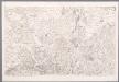
III, uit: Carte chorographique des Pays-Bas Autrichiens / ... par le Comte de Ferraris ; gravée par L.A. Dupuis
1 : 86400 Annotatie: Lit.: Les militaires et la cartographie des Pays-Bas méridionaux et de la Principauté de Liège à la fin du XVIIe et au XVIII siècle / Claire Lemoine-Isabeau. - Bruxelles, 1984, p. 206-212; La cartographie au XVIIIe siècle et l'oeuvre du Comte de Ferraris (1726-1814) : colloque international, Spa, 8-11 sept. 1976. - Bruxelles, 1978; Met opdracht aan keizer Joseph II (bl.XVI); Met plattegrond van Brussel (bl. XXI), overzichtskaart (bl. XXII) en bladwijzer (bl. XXIII); Ontbreekt: bl. I-III en XXI; Voor aanwezige bladen zie overzichtsblad Ferraris, Johann Joseph; Dupuis, L. A. [S.l. : s.n.]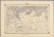
17, uit: Topografische atlas van het Koninkrijk der Nederlanden
Annotatie: Map met 19 losse krt. schaal 1:200.000 en 1 bladwijzer schaal 1:1.000.000 ['s-Gravenhage : Ministerie van Oorlog, Topografisch Bureau]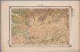
22. Kempen, uit: Geologische kaart van Nederland : schaal van 1:200.000 / door W.C.H. Staring ; uitgevoerd door het Topographisch Bureau van Oorlog ; uitgegeven op last van Zijne Majesteit Den Koning
Annotatie: Impressum ontleend aan omslag; Kaart "Nederland de dijken weggedacht" [kaart 25] en kaart 13 (bladwijzer) vermelden het jaar 1869; Kaart 'Limburg en de Hesbaije' (bladnr. 26) vermeldt het jaar 1868; Blad 5/9 ontbreekt Topographische Inrichting, 's-Gravenhage; Topographisch Bureau Haarlem : A.C. Kruseman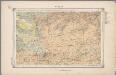
22. Kempen, uit: Geologische kaart van Nederland / door W.C.H. Staring ; bew. aan de Topographische Inrichting
1 : 200000 Winand Carel Hugo Staring 1808-1877; Topographische Inrichting, 's-Gravenhage 's-Gravenhage : Belinfante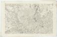
III ; 1.K., uit: Carte chorographique des Pays-Bas Autrichiens / ... par le Comte de Ferraris ; gravée par L.A. Dupuis
1 : 86400 Annotatie: Bladen linksboven genummerd met Romeinse cijfers, rechtsboven met een cijfer en een letter; Met opdracht aan keizer Joseph II (bl.XVI); Met plattegrond van Brussel (bl. XXI), overzichtskaart (bl. XXII) en bladwijzer (bl. XXIII); Annotatie geografische gegevens: Schaalstokken: Echelle de Toises ou de Lieues communes de France; Echelle de Verges ou de Lieues de Brabant; Echelle de Milles d'Allemagne (bl. XVII); Echelle de Mètres; In de hoeken lengte- en breedtematen T.M.e en T.P.e Joseph-Jean François Ferraris Comte de 1726-1814; L.A. Dupuis [S.l. : s.n.]
S.R.I. sive Antverpiae Marchionatus, et Dominium Mechliniae
1 : 100000 Mollova mapová sbírka Allard, Carel Covens, Johannes I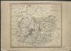
Brabant méridional, divisé en arrondissemens et cantons de justice de paix
1 : 190000 dressé et gravé par C. van Baarsel et Fils. A Amsterdam [etc.] : chez F.J. Weygand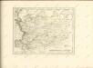

Mechlinia Dominium, et Aerschot Ducatus [Karte], in: Le théâtre du monde, ou, Nouvel atlas contenant les chartes et descriptions de tous les païs de la terre, Bd. 1, S. 403.
1 Karte aus Atlas Blaeu, Willem Janszoon und Blaeu, Joan Blaeu, Willem Janszoon