Maps of Steinkjer

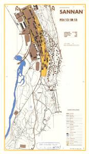
Spesielle kart 187: Instruksjonskart Sannan
1 : 5000
50D 1; 50D 2
1 : 50000 Johan Herman Severin Fougner
50D 5
1 : 50000 Per Schielderup Nissen
50C 7; 50C 8
1 : 50000 Per Schielderup Nissen
50B 9; 50B 10
1 : 50000 Johannes Solem
50C 3; 50C 4
1 : 50000 Johan Herman Severin Fougner
1722-4 Stiklestad
1 : 50000 Norges Geografiske Oppmåling
1723-3 Steinkjer
1 : 50000 Statens kartverk
1723-3 Steinkjer
1 : 50000 Statens kartverk
1723-3 Steinkjer
1 : 50000 Statens kartverk
Ekserserplasskart; Kart over Steinkjersannan med omgivelser
1 : 100000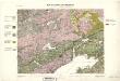
Geologiske kart 27: Den geologiske Undersøgelse, Steinkjer
1 : 100000 Theodor Kjerulf | K. M. Hauan | M. Bugge | J. Natrud Norges geologiske undersøkelse
50C Steinkjer
1 : 100000 Carl Christian Olberg | Johan Gulbrandsen Natrud
50C Steinkjer
1 : 100000
Kartblad 186: Oculair Carta over det Sparboiske Compagnie
Johan And. Klüwer
Kartblad 187: Situations Kort over det Inderøske Dragon Compagnie
Anton Ernst Roth
50C Steinkjer
1 : 100000
50B Verdal
1 : 100000 H. C. Wanggård | Ole Tolstad | Oluf Lier
50A Levanger
1 : 100000 Carl Bjune | Eriksen | Pedersen
50C Stenkjær
1 : 100000 Johan Gulbrandsen Natrud | Carl Christian Olberg
50D Snaasen
1 : 100000 Nicolai Franck | Johan Gulbrandsen Natrud
50D Snaasen
1 : 100000 Johan Gulbrandsen Natrud | Nicolai Franck
50C Stenkjær
1 : 100000 Johan Gulbrandsen Natrud | Carl Christian Olberg
50B Værdalen
1 : 100000 Oluf Lier | Johan Ferdinand Nordmann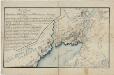
Kartblad 84: Wey-Kort over det Sparboiske Infanterie Compagnie District
Georg Friderich Coldevin
Museumskart 117: Deler av Trondheimsfjorden og Beitstadfjorden
1 : 100000 J. S. Petersen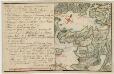
Kartblad 83: Det Inderøeske Compagnie District
Andreas Christen Bull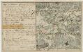
Kartblad 85: Det Sparboeske Compagnie District
Andreas Christen Bull
Kartblad 87: Det Bedstadske Compagnie Districhte
Andreas Christen Bull