Maps of Namdalseid

Maps of Namdalseid

$title$

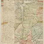
Kartblad 87: Det Bedstadske Compagnie Districhte

Andreas Christen Bull
$title$

53A Namsos

1 : 100000 Torgrim Lundtvedt | Nicolai Franck
$title$

Kartblad 88: Vejkart over Bedstadens Compagnie District

Christian Klein dy
$title$

53A Namsos

1 : 100000 Torgrim Lundtvedt | Nicolai Franck
$title$

53A Namsos

1 : 100000
$title$

53A Namsos

1 : 100000 Torgrim Lundtvedt | C. Pedersen
$title$

53A Namsos

1 : 100000 C. Pedersen | Torgrim Lundtvedt
$title$

Kartblad 84: Wey-Kort over det Sparboiske Infanterie Compagnie District

Georg Friderich Coldevin
$title$

50C Stenkjær

1 : 100000 Johan Gulbrandsen Natrud | Carl Christian Olberg
$title$

50C Stenkjær

1 : 100000 Johan Gulbrandsen Natrud | Carl Christian Olberg
$title$

50C Steinkjer

1 : 100000
$title$

50C Steinkjer

1 : 100000 Carl Christian Olberg | Johan Gulbrandsen Natrud
$title$

Geologiske kart 27: Den geologiske Undersøgelse, Steinkjer

1 : 100000 Theodor Kjerulf | K. M. Hauan | M. Bugge | J. Natrud Norges geologiske undersøkelse
$title$

50C Steinkjer

1 : 100000
$title$

Kartblad 186: Oculair Carta over det Sparboiske Compagnie

Johan And. Klüwer
$title$

1723-4 Namsos

1 : 50000 Norges Geografiske Oppmåling
$title$

1623-1 Jössund

1 : 50000 Statens kartverk
$title$

53A 7; 53A 8

1 : 50000 Gustav Heramd
$title$

53A 3; 53A 4

1 : 50000 Abraham Ludvig Amundsen
$title$

50C 11; 50C 12

1 : 50000 Abraham Ludvig Amundsen
$title$

53A 10; 53A 11

1 : 50000 Abraham Ludvig Amundsen
$title$

1623-1 Sörflatanger

1 : 50000 Norges Geografiske Oppmåling
$title$

1623-2 Holden

1 : 50000 Norges Geografiske Oppmåling
$title$

1723-4 Namsos

1 : 50000 Statens kartverk
$title$

1723-3 Steinkjer

1 : 50000 Norges Geografiske Oppmåling
$title$

1623-1 Jøssund

1 : 50000 Statens kartverk
$title$

1623-2 Holden

1 : 50000 Statens kartverk
$title$

1723-3 Steinkjer

1 : 50000 Norges Geografiske Oppmåling
$title$

1723-4 Namsos

1 : 50000 Statens kartverk
$title$

1623-1 Jøssund

1 : 50000 Statens kartverk
© MapTiler © OpenStreetMap contributors
How does it work?
These instructions will show you how to find historical maps online.
Getting started
Type the place name in the search box to find the exact location. You can further adjust the search by zooming in and out.
Zoom
Zoom in and out with the buttons or use your mouse or touchpad natively.
Exact Area tool
Click here and draw a rectangle over the map to precisely define the search area.
Set filters
Narrow your search with advanced settings, such as Years (from/to), Fulltext, Publisher, etc.
Results
See the results of your search on the right side. You can scroll down to find more maps of this location.
?

Download OldMapsOnline Mobile