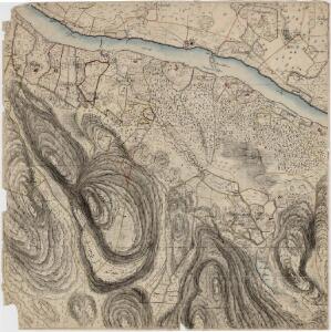
Maps of Sør-Odal

20B 9 sør øst
1 : 10000 Peter Myhre
20B 9 øst
1 : 10000 Frederich Waldemar Nicolai Beichmann | Friis
20B 9 sør
1 : 10000 Frederich Waldemar Nicolai Beichmann | Friis
fra Disen til Jelsnes
1 : 20000 J. H. Reichborn
Fra Sander til Hernes
1 : 20000 J. H. Reichborn
20B 9
1 : 50000 Gunnar Anfin Lange
20B 9
1 : 50000 Gunnar Anfin Lange | Amundsen
Kartblad II: Kart over Postveien fra Gaarden Kløften i Ullensager Sogn om Magnor til Rigsgrændsen
1 : 20000 J. H. Reichborn
2015-3 Funnefoss
1 : 50000 Statens kartverk
2015-3 Ström
1 : 50000 Norges Geografiske Oppmåling
2015-3 Ström
1 : 50000 Norges Geografiske Oppmåling
2015-3 Ström
1 : 50000 Norges Geografiske Oppmåling
2015-3 Funnefoss
1 : 50000 Statens kartverk
2015-3 Strøm
1 : 50000 Statens kartverk
20B 5
1 : 50000 Johannes Solem
Nr. 8; felt 13
1 : 25000 O. Berg
Nr. 8; dele av felt 5 og 9
1 : 25000 R. Roscher Nielsen
20B 9 sv
1 : 10000 Peter Myhre
20B 9 vest
1 : 10000 Frederich Waldemar Nicolai Beichmann | Friis
20B 5 nø
1 : 10000 Ramm | Niels Stockfleth Darre
20B 10 sv
1 : 10000 Heramb | Hansen
20B 9 sv
1 : 10000 Peter Myhre
2015-4 Odalen
1 : 50000 Norges Geografiske Oppmåling
2015-4 Odalen
1 : 50000 Norges Geografiske Oppmåling
2015-3 Strøm
1 : 50000
2015-4 Skarnes
1 : 50000 Statens kartverk
2015-3 Ström
1 : 50000 Statens kartverk
Trigonometrisk grunnlag, vedlegg 22: Kvadratmilien No 97, kvadratmilen No 58
1 : 10000
Trigonometrisk grunnlag, vedlegg 3 Fundament Kaartover den Østre Halvdeel af Qvadrat Milen No 120
1 : 10000