Maps of Sør-Odal

20B 9 sv
1 : 10000 Peter Myhre
20B 9 sv
1 : 10000 Peter Myhre
20B 9 sør
1 : 10000 Frederich Waldemar Nicolai Beichmann | Friis
20B 9 vest
1 : 10000 Frederich Waldemar Nicolai Beichmann | Friis
20B 9
1 : 50000 Gunnar Anfin Lange
20B 9
1 : 50000 Gunnar Anfin Lange | Amundsen
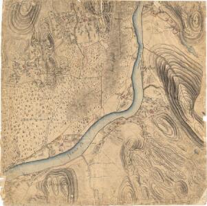
Kartblad II: Kart over Postveien fra Gaarden Kløften i Ullensager Sogn om Magnor til Rigsgrændsen
1 : 20000 J. H. Reichborn
fra Disen til Jelsnes
1 : 20000 J. H. Reichborn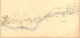
Fra Oppåker til Ullern kirke
1 : 20000 J. H. Reichborn
20B 5
1 : 50000 Johannes Solem
20B 9 sør øst
1 : 10000 Peter Myhre
2015-3 Funnefoss
1 : 50000 Statens kartverk
2015-3 Ström
1 : 50000 Norges Geografiske Oppmåling
2015-3 Ström
1 : 50000 Norges Geografiske Oppmåling
2015-3 Ström
1 : 50000 Norges Geografiske Oppmåling
2015-3 Funnefoss
1 : 50000 Statens kartverk
2015-3 Strøm
1 : 50000 Statens kartverk
2015-4 Odalen
1 : 50000 Norges Geografiske Oppmåling
2015-4 Odalen
1 : 50000 Norges Geografiske Oppmåling
2015-3 Strøm
1 : 50000
2015-4 Skarnes
1 : 50000 Statens kartverk
2015-3 Ström
1 : 50000 Statens kartverk
Trigonometrisk grunnlag, vedlegg 22: Kvadratmilien No 97, kvadratmilen No 58
1 : 10000
Trigonometrisk grunnlag, vedlegg 3 Fundament Kaartover den Østre Halvdeel af Qvadrat Milen No 120
1 : 10000
20B Kongsvinger
1 : 100000
Geologiske kart 30: Den geologiske Undersøgelse, Nannestad
1 : 100000 T. Ch. Thomassen | Normann | Johan H. L. Vogt Norges geologiske undersøkelse
Geologisk kart 10 Nannestad
1 : 100000
20B Kongsvinger
1 : 100000 H. Hagen | Torgrim Lundtvedt
20A Nannestad
1 : 100000 Johan Ferdinand Normann | Carl Christian Olberg