Maps of Søgne

1D 8; 1D 12; 2C 9
1 : 50000 Gustav Heramd
Innseiling til Ny-Hellesund
1 : 20000 Schie Opmaalings Directionen
D40-5 vm/6, D40-5 sm/6
1 : 25000 Salterød
D40-4
1 : 25000 Niels Sire | Alf Hattestad | H. A. Holmsen
1511-3 Kristiansand
1 : 50000 Statens kartverk
1511-3 Kristiansand
1 : 50000 Norges Geografiske Oppmåling
1511-3 Kristiansand
1 : 50000 Norges Geografiske Oppmåling
2C 9 5A 1
1 : 50000 Daniel TÃ ̧nnesen
1D 7; 1D 8; 1D 11; 1D 12
1 : 50000 Jacob Meidell
1D 7; 1D 11
1 : 50000 Gulbrandson | Lier | Hilmar Krogh Borchgrevinck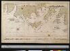
Een gedeelte van de Zuidkust van Noorwegen bij het eiland Flekkeröy en Kristansand aan het Skagerrak
Norway Gerard van Keulen
2C 5 2C 6 2C 9 2C 10
1 : 50000 A. Bergh
1511-3 Kristiansand
1 : 50000 Statens kartverk
1511-3 Kristiansand
1 : 50000 Norges Geografiske Oppmåling
1511-3 Kristiansand
1 : 50000 Statens kartverk
1D 7; 1D 11
1 : 50000 Hilmar Krogh Borchgrevinck | Gulbrandson
D40-4 ø/2, D40-5 v/2
1 : 25000 Alf Hattestad
D40-5 øm/6
1 : 25000 Gustav Adolf Tajet
D40-4 nø/6
1 : 25000 Erling Bjørstad
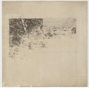
Innseiling til Kristiansand
1 : 20000 Schie Opmaalings Directionen
Museumskart 74: Speciel Kaart over Havnen ved Mæbye paa ydre-Flekkerøe
1 : 10000 Carl Frederik Grove
Museumskart 65: Kart over Den Norske Kyst fra Christiansand til Lindesnæs
1 : 150000 Schie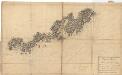
Museumskart 75: Speciel Kaart over en Deel af Den Norske SøeKyst
1 : 50000 Carl Frederik Grove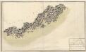
Museumskart 76: Speciel Kaart over en Deel af Den Norske SøeKyst
1 : 50000 Carl Frederik Grove
Museumskart 217-25: Kart over Den Norske Kyst fra Christiansand til Lindesnæs
1 : 50000 H. Wille | Schie Opmaalings Directionen
2C Oksø
1 : 100000
1D Mandal
1 : 100000 Oluf Lier | Ole Engh
Kartblad 143- Geographiske Wej-Cart over det 2det Mandahlske Compagnie District; versjon 1

Kartblad 143-2: Geographiske Wej-Cart over det 2det Mandahlske Compagnie District; versjon 2