Maps of Søgne

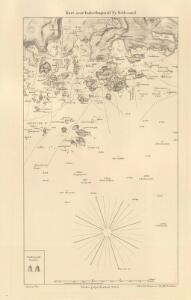
Innseiling til Ny-Hellesund
1 : 20000 Schie Opmaalings Directionen
D40-4
1 : 25000 Niels Sire | Alf Hattestad | H. A. Holmsen
1D 8; 1D 12; 2C 9
1 : 50000 Gustav Heramd
1511-3 Kristiansand
1 : 50000 Norges Geografiske Oppmåling
D40-5 vm/6, D40-5 sm/6
1 : 25000 Salterød
2C 5 2C 6 2C 9 2C 10
1 : 50000 A. Bergh
D40-4 ø/2, D40-5 v/2
1 : 25000 Alf Hattestad
1511-3 Kristiansand
1 : 50000 Statens kartverk
Museumskart 65: Kart over Den Norske Kyst fra Christiansand til Lindesnæs
1 : 150000 Schie
2C Oksø
1 : 100000
1511-3 Kristiansand
1 : 50000 Norges Geografiske Oppmåling
1D Mandal
1 : 100000 Oluf Lier | Ole Engh
Museumskart 60a: Kart over strekningen Kristiansand-Risør
1 : 200000 Rasmus Iuel
Kartblad 143- Geographiske Wej-Cart over det 2det Mandahlske Compagnie District; versjon 1

Kartblad 143-2: Geographiske Wej-Cart over det 2det Mandahlske Compagnie District; versjon 2

Kartblad 142: Situations-Charte over det 2det Mandahlske Compagnie District
J. Kraft
2C 9 5A 1
1 : 50000 Daniel TÃ ̧nnesen
Een gedeelte van de Zuidkust van Noorwegen bij het eiland Flekkeröy en Kristansand aan het Skagerrak
Norway Gerard van Keulen
2C Oksø
1 : 100000 Oluf Lier | Johan Nordhagen
2C Oksø
1 : 100000 Oluf Lier | Johan Nordhagen
2C Oksø
1 : 100000 Oluf Lier | Johan Nordhagen
2C Oksø
1 : 100000 Johan Nordhagen | Oluf Lier
2C Oksø
1 : 100000 Oluf Lier | Johan Nordhagen
1511-3 Kristiansand
1 : 50000 Statens kartverk
1511-3 Kristiansand
1 : 50000 Norges Geografiske Oppmåling
1511-3 Kristiansand
1 : 50000 Statens kartverk
1D 7; 1D 8; 1D 11; 1D 12
1 : 50000 Jacob Meidell
1D Mandal
1 : 100000 H. Wangård | Oluf Lier
1D Mandal
1 : 100000 H. Wangård | Oluf Lier