Maps of Sørfold
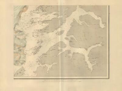
Museumskart 217-50: Fiskekart over den indre del af Vestfjorden i Lofoten
1 : 100000 M. Lyng Den Geografiske Opmaaling
K12 Kjerringøy
1 : 100000 Arnt Magnus Andreassen Øgaard | C. Pedersen
K12 Kjerringøy
1 : 100000 Arnt Magnus Andreassen Øgaard | H. C. Wanggård
K12 Kjerringøy
1 : 100000 Arnt Magnus Andreassen Øgaard | C. Pedersen
K11 Steigen
1 : 100000 Ole Bernhard Tolstad | C. Pedersen
K11 Steigen
1 : 100000 Ole Bernhard Tolstad | C. Pedersen
K11 Steigen
1 : 100000 Ole Bernhard Tolstad | C. Pedersen
K11 Steigen
1 : 100000
L11 Nordfold
1 : 100000 Torgrim Lundtvedt | Ole Engh
K12 Kjerringøy
1 : 100000
K12 Kjerringøy
1 : 100000 Arnt Magnus Andreassen Øgaard | H. C. Wanggård
K12 Kjerringøy
1 : 100000
L12 Sørfold
1 : 100000
L12 Sørfold
1 : 100000
L12 Sørfold
1 : 100000
L12 Sørfold
1 : 100000
L12 Sørfold
1 : 100000
L12 Sørfold
1 : 100000
2130-3 Helldalisen
1 : 50000 Statens kartverk
2130-3 Helldalisen
1 : 50000 Norges Geografiske Oppmåling
2130-3 Helldalisen
1 : 50000 Statens kartverk
2130-3 Helldalisen
1 : 50000 Norges Geografiske Oppmåling
L11 sørvestre del
1 : 50000 Kristian Kristiansen Laake
L12 nordøstre del
1 : 50000 Sigurd Sandvik | Otto Hjersing Munthe-Kaas | William Steffens | Bent Eskildssøn Bentzen
L11 sørvestre del
1 : 50000 Kristian Kristiansen Laake | Thorleif Barlag
K12 sørøstre del
1 : 50000 Oluf Gabriel Lund | Wolfgang Wentzel Haffner | Nils Hartvig Ruud
L12 nordøstre del
1 : 50000 Otto Hjersing Munthe-Kaas
Spesielle kart 40: Oversigtskroki over Ruotevare Jernbanens norske del
1 : 20000
2030-3 Slovær
1 : 50000 Norges Geografiske Oppmåling