Maps of North Rhine-Westphalia

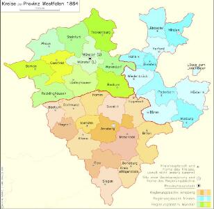
Kreise der Provinz Westfalen 1864
Preußen, Westfalen, Verwaltungsgliederung Kunz, Andreas ; Moeschl, Joachim Robert
Westphalen.
1 : 720000 Flemming, Carl
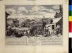
Übersichts-Karte der Operationen der allirten und französischen Armee von Eröffnung des Sommerfeldzuges bis zur Schlacht bei Vellinghausen oder vom Anfang Juni bis 15t Juli 1761
1 : 600000
Circvli Westphalici Pars Septentrionalis
1 : 2200000 Mollova mapová sbírka Franz, Johann Michael Homann, Johann Baptista - dědici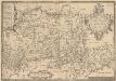
Westphaliae Totius, Finitimarumque Regionum Accurata Descriptio. [Karte], in: Theatrum orbis terrarum, S. 216.
1 Karte aus Atlas Ortelius, Abraham Vrients, Jan Baptista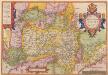
Westphaliae Totius, Finitimarumque Regionum Accurata Descriptio. [Karte], in: Theatrum orbis terrarum, S. 124.
1 Karte aus Atlas Ortelius, Abraham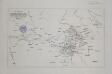
Zur Übersicht der Operationen der alliirten und französischen Armee vom Übergange des Marschall von Broglio über die Weser 24ten Aug. bis zum Ubergange der allirten Armee über diesen Fluss 4ten November 1761
1 : 600000
Cöln, Cassel, Hannover, Osnabrück, Fulda
1 : 750000 Fulda (Německo) Lorenz, K. K. u. k. Militärgeographisches Institut
Cöln, Cassel, Hannover, Osnabrück, Fulda
1 : 750000 Fulda (Německo) K. k. militär-geographisches Institut
[Westfaliae secunda tabula]
1 Karte : Kupferdruck ; 34 x 44 cm Mercator; Hondius sumptibus Henrici Hondij
[Westfaliae secunda tabula]
1 Karte : Kupferdruck ; 34 x 44 cm Mercator s.n.
[Westfalen] [Karte], in: Gerardi Mercatoris Atlas, sive, Cosmographicae meditationes de fabrica mundi et fabricati figura, S. 343.
1 Karte aus Atlas Mercator, Gerhard Montanus, Petrus
[Westphalen] [Karte], in: Gerardi Mercatoris et I. Hondii Newer Atlas, oder, Grosses Weltbuch, Bd. 1, S. 161.
1 Karte aus Atlas Mercator, Gerhard und Hondius, Jodocus Jansson, Jan
Ducatvs Westphaliae
1 : 270000 Vestfálsko (Německo) Zittart, D. studio Hommanianorum Heredum
Ducatvs Westphaliae
1 : 270000 Vestfálsko (Německo) Zittart, D. studio Hommanianorum Heredum

Operationum bellicarum in Germania ulterior Repraesentatio
1 : 700000 Mollova mapová sbírka Rizzi Zannoni, Giovanni Antonio Homann, Johann Baptista - dědici
Monasteriensis Et Osnaburgensis Episcopatus Descriptio. [Karte], in: Theatrum orbis terrarum, S. 245.
1 Karte aus Atlas Ortelius, Abraham Vrients, Jan Baptista
Westphaliae totivs, finitimarvmqve regionvm accvrata descriptio
1 Karte : Kupferdruck ; 33 x 48 cm Sgrooten; Ortelius s.n.
Monasteriensis Et Osnaburgensis Episcopatus Descriptio. [Karte], in: Theatrum orbis terrarum, S. 153.
1 Karte aus Atlas Ortelius, Abraham
Carte Du Théatre De La Guerre Présente En Westphaliae Avec Les Pays Voisins
1 : 290000 Mollova mapová sbírka Rizzi Zannoni, Giovanni Antonio Back, Jakob Conrad Broenner, Heinrich Ludwig
Generalkarte von Zentraleuropa

Ducatus Iuliacensis, Cliviensis, Montensis: et Comitatus Marciae et Rapens-Bergae finitimaeque eis Regiones [...] [Karte], in: Novus atlas absolutissimus, Bd. 2, S. 136.
1 Karte aus Atlas Janssonius Offizin
Ducatus Iuliacensis Cliviensis et Montensis
1 : 400000 Mollova mapová sbírka Seutter, Matthäus Seutter, Matthäus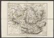
Berge Ducatus Marck Comitatus. [Karte], in: Gerardi Mercatoris et I. Hondii Newer Atlas, oder, Grosses Weltbuch, Bd. 1, S. 188.
1 Karte aus Atlas Mercator, Gerhard und Hondius, Jodocus Jansson, Jan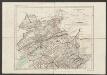
De Hertochdommen Gulick Cleve Berghe en de Graefschappen vander Marck En Ravensbergh. [...] [Karte], in: Gerardi Mercatoris et I. Hondii Newer Atlas, oder, Grosses Weltbuch, Bd. 1, S. 179.
1 Karte aus Atlas Mercator, Gerhard und Hondius, Jodocus Jansson, Jan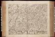
Berge ducatus, Marck comitatus / [Henricus Hondius]
1 : 250000 Annotatie: Het eerst verschenen in: Gerardi Mercatoris et I. Hondii atlas appendix ... - Ambsterdam : bey Johan Jansson, 1636; Origineel is Blad 70 in atlas factice; Met inzet van de omgeving van Soest; Annotatie geografische gegevens: Noordoost boven Hondius, Henricus Amstelodami : sumptibus Henrici Hondii