Maps of Regierungsbezirk Münster

[Westphalen] [Karte], in: Gerardi Mercatoris et I. Hondii Newer Atlas, oder, Grosses Weltbuch, Bd. 1, S. 161.
1 Karte aus Atlas Mercator, Gerhard und Hondius, Jodocus Jansson, Jan
[Westfalen] [Karte], in: Gerardi Mercatoris Atlas, sive, Cosmographicae meditationes de fabrica mundi et fabricati figura, S. 343.
1 Karte aus Atlas Mercator, Gerhard Montanus, Petrus
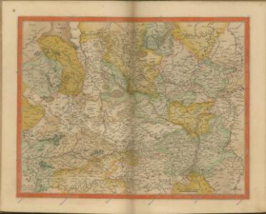
[Westfaliae secunda tabula]
1 Karte : Kupferdruck ; 34 x 44 cm Mercator; Hondius sumptibus Henrici Hondij
[Westfaliae secunda tabula]
1 Karte : Kupferdruck ; 34 x 44 cm Mercator s.n.
Westphaliae = Westphalen = Westfalie
1 : 1000000 titelvariant: Westphalen; Westfalie [S.l. : s.n.]
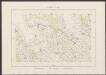
Kreise der Provinz Westfalen 1864
Preußen, Westfalen, Verwaltungsgliederung Kunz, Andreas ; Moeschl, Joachim Robert
Monasteriensis Et Osnaburgensis Episcopatus Descriptio. [Karte], in: Theatrum orbis terrarum, S. 153.
1 Karte aus Atlas Ortelius, Abraham
Monasteriensis Et Osnaburgensis Episcopatus Descriptio. [Karte], in: Theatrum orbis terrarum, S. 245.
1 Karte aus Atlas Ortelius, Abraham Vrients, Jan Baptista

Episcopatuum Monasteriensis et Osnabrugensis ut et comitatum Bentheim, Teclenburg, Stenford, Lingen, Diepholt, Delmenhorst, Rietberg etc. etc. novissima et accuratissima designatio
1 : 330000 cura et sumptibus Tobiae Conradi Lotter Tob. Con. Lotter sculp. Aug. Vind : Tob. Conr. Lotter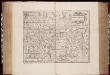
Monasteriensis episcopatus / [Joannes Janssonius]
1 : 450000 Annotatie: Rechtsboven: XXVI; Verschenen in: The English atlas volume III ... - Amsterdam : J. Jansonius a Waesberg and S. Swart, 1683; 1e staat: Amstelodami : apud Ioannem Ianssonium, [1630]; Origineel is Blad 76 in atlas factice; Annotatie geografische gegevens: West boven Janssonius, Joannes (jr.) (1588-1664) [Amsterdam : J. Jansonius van Waesberge etc.]
Episcopatus Monasteriensis et Osnabrugensis nec non Comitatuum Bentheim Teckelenburg Stanford Lingen Diepholt Delmenhorst Ritberg etc. Tabula
1 : 410000 Mollova mapová sbírka Danckerts, Justus Danckerts, Justus
Monasteriensis Episcopatus. [Karte], in: Novus atlas absolutissimus, Bd. 2, S. 118.
1 Karte aus Atlas Janssonius Offizin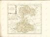
Monasteriensis Episcopatus. [Karte], in: Theatrum orbis terrarum, sive, Atlas novus, Bd. 1, S. 209.
1 Karte aus Atlas Blaeu, Joan Blaeu, Willem Janszoon
Monasteriensis Episcopatus. [Karte], in: Le théâtre du monde, ou, Nouvel atlas contenant les chartes et descriptions de tous les païs de la terre, Bd. 1, S. 160.
1 Karte aus Atlas Blaeu, Willem Janszoon und Blaeu, Joan Blaeu, Willem Janszoon
Monasteriensis Episcopatus. [Karte], in: Novus Atlas, das ist, Weltbeschreibung, Bd. 1, S. 129.
1 Karte aus Atlas Blaeu, Joan Blaeu, Willem Janszoon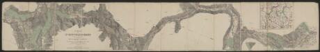
Monasteriensis Episcopatus. [Karte], in: Gerardi Mercatoris et I. Hondii Newer Atlas, oder, Grosses Weltbuch, Bd. 1, S. 164.
1 Karte aus Atlas Mercator, Gerhard und Hondius, Jodocus Jansson, Jan
Charte von Wesergebirge
1 : 925000
CHARTE von WESERGEBIRGE
1 : 925000 Dolní Sasko (Německo)
Monasteriensis et Osnabvrgensis Episcopatvs
1 : 490000 Mollova mapová sbírka Maschop, Gottfried
Übersichts Karte der Operationen von der Schlacht bei Vellinghausen bis zum Übergange des Marschalls Broglio über die Weser, vom 16ten Juli bis 21ten August 1761

Rev.mo et Seren.mo Principi ac Domo. Dn. Ferdinando Archiep. et Elect. Colon. Episcop. Monasteriens Leto, Duci Bavariae
Mollova mapová sbírka Gigas, Johann Michael
Carte Nouvelle de l'Eveché de Munster
1 : 180000 Mollova mapová sbírka Grancourt
Carta del vescovato di Mvnster
1 : 480000 Münster in Westfalen-oblast (Německo) Bouttats, Gerhaert Hacque, Johann Baptist
Carta del vescovato di Mvnster
1 : 480000 Münster in Westfalen-oblast (Německo) Bouttats, Gerhaert Hacque, Johann Baptist
Monasteriensis episcopatvs
1 : 485000 Münster in Westfalen-oblast (Německo) Janssonius, Johannes apud Ioannem Ianßonium
Monasteriensis episcopatus
1 : 485000 Münster in Westfalen-oblast (Německo) Gigas, Johann Michael Blaeu, Willem Janszoon apud Guiljelmum Blaeuw