Maps of Slovenia

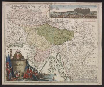
Tabula Ducatus Carnioliae Vindorum Marchiae et Histriae ex mente Illustr.mi quondam L. B. Valvasorii concinnata et exhibita â Io. Bapt. Homanno S. C. M. Geogr.
Krain, Istrien Valvasor, Johann Weikhard <
Sclauonia oder Windisch Marck, Bossen, Crabaten, ec
1 : 1200000 1 Karte : Holzschnitt ; 29 x 34 cm Münster, Sebastian [Sebastian Henricpetri]
Exactissima Ducatus Carniolae Vinidorum Marchiä et Histriae
1 : 500000 Mollova mapová sbírka Seutter, Matthäus
Descriptio Totius Lyridis XVI. No. Tab. [Karte], in: Claud. Ptolemaeus. Geographia lat. cum mappis [...], S. 404.
1 Karte aus Atlas Münster, Sebastian [und Ptolemaeus, Claudius]
Goritiae, Karstii, Chaczeolae, Carniolae, Histriae, Et Windorum Marchae Descrip. [Karte], in: Theatrum orbis terrarum, S. 186.
1 Karte aus Atlas Ortelius, Abraham
Zemljovid slovenske dežele in pokrajin
Slowenien Knorr, A.
Carte del regno d'Illiria e del ducato Stiria
1 : 860000 Ilýrie Raffelsperger, Franz nel magazeno delle carte tipografiate
Strassen- und Eisenbahnkarte des oesterreichischen Kaiserthumes
1 : 864000 Blatt 10 Schaller, G. K.K. Militärisch-Geografisches Institut, Karten-Evidenthaltungs-Abteilung
Goritiae, Karstii, Chaczeolae, Carniolae, Histriae, Et Windorum Marchae Descrip. [Karte], in: Theatrum orbis terrarum, S. 281.
1 Karte aus Atlas Ortelius, Abraham Vrients, Jan Baptista
Exactissima Ducatus Carniolae vinidorum Marchiä et Histriae delineatio
1 : 500000 Chorvatsko Lotter, Tobias Conrad T. C. Lotter
Exactissima ducatus Carniolae Vinidorum Marchiä et Histriae delineatio
1 : 500000 Cirknické jezero (Slovinsko) Lotter, Tobias Conrad Tob. Conr. Lotter
Exactissima ducatus Carniolae Vinidorum Marchiä et Histriae delineatio
1 : 500000 Cirknické jezero (Slovinsko) Lotter, Tobias Conrad Tob. Conr. Lotter
Exactissima Ducatus Carniolae vinidorum Marchiä et Histriae delineatio
1 : 500000 Chorvatsko Lotter, Tobias Conrad T. C. Lotter
Strassen und Eisenbahnkarte des oesterreichischen Kaiserthumes

Das Königreiche Illyrien und das Herzogthum Steyermark
1 : 700000 Ilýrie Weiland, Karl Ferdinand Anson im Verlage des geographischen Instituts
Das Königreiche Illyrien und das Herzogthum Steyermark
1 : 700000 Ilýrie Weiland, Karl Ferdinand Anson im Verlage des geographischen Instituts
Charte von dem Königreiche Illyrien und dem Herzogthume Steyermark
1 : 690000 Ilýrie Weiland, Karl Ferdinand Bürck, A. im Verlage des Geograph. Instituts
Charte von dem Königreiche Illyrien und dem Herzogthume Steyermark
1 : 690700 Ilýrie Weiland, Karl Ferdinand Bürek, A. im Verlage des Geograph. Instituts
Illyricvm
1 : 1200000 Mollova mapová sbírka Sambucus, Joannes
Carte du royaume d'Illirie et du duché de Styrie
1 : 520000 Ilýrie Raffelsperger, Franz Rumpold, F. au Dépôt des cartes typografiées
Karte von Inner-Österreich, das ist des Königreiches Illirien und des Herzogthumes Steiermark
1 : 880000 Ilýrie Raffelsperger, Franz Rumpold, F. im Typographischen Landkarten-Verlage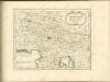

Das Königreich Illyrien und das Herzogthum Steyermark
1 : 700000 Ilýrie Weiland, Karl Ferdinand im Verlage des geographischen Instituts
Oesterr. Kronlander.
1 : 700000 Weiland, C. F. (Carl Ferdinand), d. 1847
Herzogthümer Steiermark, Kärnten, Krain, die gefürstete Graftschaft Görz und Gradiska, die Markgraftschaft Istrien, die Stadt Triest mit Gebiet und das ungarische Littorale
1 : 600000 Steiermark, Kärnten Gräf, Carl
Die Herzogthümer Steiermark, Kärnten, Krain
1 : 600000 Brionské ostrovy (Chorvatsko) Gräf, Carl Geyer, Valentin Geographisches Institut
Die Herzogthümer Steiermark, Kärnten, Krain, die gefürstete Grafschaft Görz und Gradiska, die Markgrafschaft Istrien, die Stadt Triest mit Gebiet und das ungarische Litorale
1 : 550000 Brionské ostrovy (Chorvatsko) Gräf, C. Geyer, V. Geographisches Institut
Karte von Inner-Österreich, das ist des Königreiches Illirien und des Herzogthumes Steiermark
1 : 730000 Ilýrie Bermann, Jeremias im Typographischen Landkarten-Verlage
Die Kronländer Kärnthen, Krain, Görz und Gradisca, Istrien und die reichsunmittelbare Stadt Triest nach ihrer neuesten gerichtlichen & politischen Eintheilung
Gorice a Gradiška Bermann, Joseph Joseph Bermann