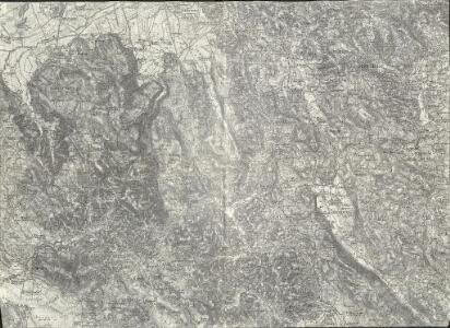
Maps of Velike Lašče
Weixelburg (?)
1 : 75000 Višnja Gora
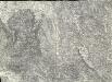
Yugoslavia 1:100,000, Cerknica
Yugoslavia 1:100,000 , Series GSGS 4396. Great Britain. War Office. [London] : War Office
Weixelburg und Zirknitz.
from Spezialkarte der osterreichisch-ungarischen Monarchie.
Ducatus Carnioliae Tabula Chorographica Iusu Sumptuque inclytorum Provinciae Statuum.
1 : 100000 Mollova mapová sbírka Florjančič de Grienfeld, Janez Dizma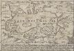
Der Czirknitzer See
Zirknitzer See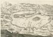
Cirkhnizer See
Mollova mapová sbírka Merian, Matthaeus Merian, Matthäus - dědici
Naseljenost prebivalstva na Kranjskem
1 : 400000 Kraňsko Lončar, Dragotin Kaisvinkler, Bohumil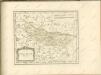

Übersicht der Krainer Metulum-Hypothesen
1 : 750000 Kroatien Ogulin (Region) Illyrien Augustus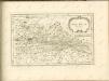

Unter Krain
1 : 500000 Unterkrain
Dioecesan-Carte von Laibach
1 : 260000 Lublaň-oblast (Slovinsko) Mascon, Johann Wolf, Anton Alojzij Johann Mascon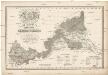
Mappa comitatus Zagrabiensis
1 : 240000 Záhřeb-oblast (Chorvatsko) Szemán, Joseph Kaiser, J. F.
Aus der Übersichtskarte von Mittel-Europa 1:750 000
1 : 750000 Evropa střední K. k. Österreichische Staatsbahnen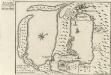
Buccari samt dessen Seehafen und derer tieffen in Istrien am Adriatischen Meer gelegen dem Kayser gehörig
Mollova mapová sbírka Bodenehr, Gabriel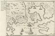
Accurater Plan des Kayserliche freyen See-Hafen Fiume oder S. Veit am Flaun, an den Grentzen des Hertzogthus Crain und des Oesterreichischen Istrien am Golfo di Carnero, und am Einfluss des Flusses Fiume
Mollova mapová sbírka Bodenehr, Gabriel
Ljubljana
1 : 200000 Lublaň (Slovinsko : oblast) Kartografska radionica
Laibach.
from Spezialkarte der osterreichisch-ungarischen Monarchie.
Italy 1:100,000 / Sardinia 1:100,000, Postumia
Italy 1:100,000 / Sardinia 1:100,000 , Series GSGS 4164. Great Britain. War Office. General Staff. Geographical Section. [London] : War Office
Laas und Cabar.
from Spezialkarte der osterreichisch-ungarischen Monarchie.
Rudolfswerth.
from Spezialkarte der osterreichisch-ungarischen Monarchie.
Adelsberg.
from Spezialkarte der osterreichisch-ungarischen Monarchie.
Umgebung von Adelsberg
1 : 72000 Postojna (Slovinsko) Pauliny, Jacob Josef K. k. Schulbücher Verlag
Umgebung von Adelsberg
1 : 72000 Postojna (Slovinsko) Pauliny, Jacob Josef K. k. Schulbücher Verlag
Generalkarte von Zentraleuropa

Istria, olim Lapidia. [Karte], in: Novus atlas absolutissimus, Bd. 5, S. 65.
1 Karte aus Atlas Janssonius Offizin
Karte vom Herzogthum Krain
1 : 290000 Kraňsko Loschan, Gottfried Stein, Carl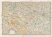
Karte des Krainisch-Kroatischen Gebirgslandes
1 : 250000 Chorvatsko Ravenstein, Ludwig Ludwig Ravenstein
Istria olim Iapidia [Karte], in: Gerardi Mercatoris et I. Hondii Newer Atlas, oder, Grosses Weltbuch, Bd. 2, S. 261.
1 Karte aus Atlas Mercator, Gerhard und Hondius, Jodocus Jansson, Jan