Maps of Istria County

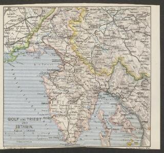
Golf von Triest und Istrien
1 : 1000000 Italien Slowenien Kroatien Golf von Triest
Istria olim Iapidia [Karte], in: Gerardi Mercatoris et I. Hondii Newer Atlas, oder, Grosses Weltbuch, Bd. 2, S. 261.
1 Karte aus Atlas Mercator, Gerhard und Hondius, Jodocus Jansson, Jan
Istria, olim Lapidia. [Karte], in: Novus atlas absolutissimus, Bd. 5, S. 65.
1 Karte aus Atlas Janssonius Offizin
Königreich Illyrien Charte des gouvernements Triest
1 : 450000 Ilýrie Renner A. Plott
Ducatus Carnioliae tabula
1 : 648000 Istrijský poloostrov (Slovinsko a Chorvatsko) Granelli, Carlo Engelbrecht, Christian C. E. et I.A. P.
Carnioia
Mollova mapová sbírka Hoffmann, Johannes Hoffmann, Johann
Carta del litorale Austriaco
Istrijský poloostrov (Slovinsko a Chorvatsko) Schwarzer von Heldenstamm, Ernst
Buccari samt dessen Seehafen und derer tieffen in Istrien am Adriatischen Meer gelegen dem Kayser gehörig
Mollova mapová sbírka Bodenehr, Gabriel
Accurater Plan des Kayserliche freyen See-Hafen Fiume oder S. Veit am Flaun, an den Grentzen des Hertzogthus Crain und des Oesterreichischen Istrien am Golfo di Carnero, und am Einfluss des Flusses Fiume
Mollova mapová sbírka Bodenehr, Gabriel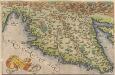
Histriae tabula [Karte], in: Theatrum orbis terrarum, S. 262.
1 Karte aus Atlas Ortelius, Abraham
Istria olim Iapidia [Karte], in: Novus Atlas, das ist, Weltbeschreibung, Bd. 3, S. 151.
1 Karte aus Atlas Blaeu, Joan Blaeu, Willem Janszoon
Ducatus Carnioliae accuratissima Delineatio per
1 : 670000 Mollova mapová sbírka Weigel, Christoph Köhler, Johann David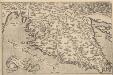
Histriae tabula [Karte], in: Theatrum orbis terrarum, S. 357.
1 Karte aus Atlas Ortelius, Abraham Vrients, Jan Baptista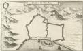
Grondtris der Statt Zeng
Mollova mapová sbírka Merian, Matthaeus Merian, Matthäus
Istria olim Iapidia [Karte], in: Theatrum orbis terrarum, sive, Atlas novus, Bd. 3, S. 131.
1 Karte aus Atlas Blaeu, Joan Blaeu, Willem Janszoon
Istria olim Iapidia [Karte], in: Le théâtre du monde, ou, Nouvel atlas contenant les chartes et descriptions de tous les païs de la terre, Bd. 3, S. 155.
1 Karte aus Atlas Blaeu, Willem Janszoon und Blaeu, Joan Blaeu, Willem Janszoon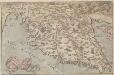
Histriae tabula
Istrien Coppo. Pietro
Karte des k. k. Küstenlandes
Chorvatsko Kettner, Vinzenz Förster, L.
Istrie
1 : 750000 Machát, František c. a k. voj. zeměpisný ústav
Fori Ivlii accvrata descriptio
1 Karte : Kupferdruck ; 34 x 46 cm Sambucus; Ortelius s.n.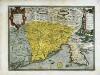
Fori Ivlii accvrata descriptio
1 Karte : Kupferdruck ; 34 x 46 cm Sambucus; Ortelius s.n.
Karte der Kronländer Görz mit Gradisca und Istrien und der reichsunmittelbaren Stadt Triest mit deren politischen und gerichtlichen Eintheilung
Gorice a Gradiška Kettner, Vincenz
Adriatisches Meer, Küstenkarte
1 : 180000 Istrijský poloostrov (Slovinsko a Chorvatsko) Oesterreicher, Tobias von Hydrographisches Amt der k. u. k. Kriegsmarine
Adriatisches Meer, Küsten-Karte
1 : 180000 Istrijský poloostrov (Slovinsko a Chorvatsko) Oesterreicher, Tobias von Hydrographisches Amt der k. u. k. Kriegs-Marine
Istria olim Iapidia
1 : 310000 Istrijský poloostrov (Slovinsko a Chorvatsko) Janssonius, Johannes sumptibus Ioannis Ianssonii
Carta del litorale Austriaco
1 : 440000 Istrijský poloostrov (Slovinsko a Chorvatsko) Schwarzer, Ernesto de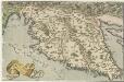
Histriae tabula
1 : 400000 Mollova mapová sbírka Coppo, Pietro Ortelius, Abraham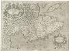
Istria olim Iapidia
1 : 300000 Mollova mapová sbírka Magini, Giovanni Antonio Magini, Fabio