Maps of Albania

Geografia Argentinae
Albanien
[Nordalbanien ; Montenegro]
Albanien
Černá Hora, Sandžak Novopazarský se západní hranicí Srbska, západní pole bitevní na Balkáně
1 : 580000 Novi Pazar (Srbsko) Maxim
Totius Graeciae descriptio
Griechenland Albanien
(Europaischen Turkei) 3.
1 : 1580000 Berghaus, Heinrich; Flemming, Carl; Handtke, Friedrich H.; Sohr, Karl
Siedlungsgebiet der Albaner
Balkanhalbinsel Albaner, Siedlung

98. Albania. The World Atlas.
1 : 1250000 USSR (Union of Soviet Socialist Republics).
Gewässerkarte von Albanien
Albanien Hydrologie Péch, Béla
Die albanischen Grenzen
Albanien Grenzen Häusler, Ines
Internationale Weltkarte 1:1.000.000
1 : 1000000 Evropa jihovýchodní War Office
Serbien und Montenegro
1 : 1000000 Srbsko von Velhagen & Klasing
La triangulation trigonometrique de I ere classe
1 : 1500000 Srbsko Bošković, S. P. L'institut Géographique de l'Armée
Albanie - Monténégro: Structure Physique et Routes
Albanien Montenegro Geländedarstellung Verkehrsweg
Der Noerdliche Theil Des Koenigreichs Albanien mit dem Distrikte Montenegro
1 : 1400000 Albanien, Montenegro
Albanisches Insurrectionsgebiet 1444
1 : 2500000 Albanien Aufstand
[Nordalbanien]
Albanien
Atlas
Albanien
Neubertova podrobná příruční mapa Abanie

Speculum orbis Terrarum
Albanien
Carte generale
Albanien
Montenegro
Montenegro
Urbinas Handschrift
Albanien Trattato della pittura / Handschrift / Rom / Vatikanische Bibliothek / Cod. Urb. Lat.
Hungaria
Albanien Ungarn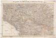
Das Sandschak Novi Bazar, Nord-Albanien, Neu-Serbien u[nd] Montenegro
1 : 864000 Albánie Steinhauser, Anton Artaria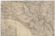
[Montenegro und angrenzende Länder]
Bělehrad (Srbsko : oblast)
Turquie d'Europe
Albanien Osmanisches Reich Reich
Atlas
Albanien
Strassen- und Eisenbahnkarte des oesterreichischen Kaiserthumes
1 : 864000 Blatt 15 Schaller, G. K.K. Militärisch-Geografisches Institut, Karten-Evidenthaltungs-Abteilung