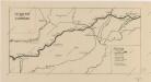
Maps of Isaszeg

Az isaszegi csata vázlata (1849 april 6-án)
Ungarn Isaszeg / Schlacht Ungarn / Revolution <1848-1849>
Hatvan und Godollo.; Spezialkarte der osterreichisch-ungarischen Monarchie.
from Spezialkarte der osterreichisch-ungarischen Monarchie. Austro-Hungarian Monarchy. Militärgeographisches Institut.,
Hatvan und Gödöllő
1 : 75000 Hatvan, Gödöllő Schrift und Gerippe v. Fwkr. Suchanek. Terrainschraffirung v. Fwkr. Nowak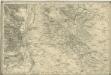
Bez titulu: Umgebungen von Pest

Haduan sampt derselben Revier wie solche von der königliche Würdin Ertzhertzog Maximiian u. auff den 16. Augusti belaegert beschossen und endtlich mit stürmender hand den 3. Septembris in disem 1596. Jar erobert worden
Fugger, Philipp Eduard Alexander Mair
A Dunavölgy Átnézeti Térképe, Carte d ́ensemble del la Vallée du Danube VIII.

Generální mapa ČSR

Mappa Comitatus Pilisiensis Methodo Astronomico-Geometrica concinnata.
1 : 162500 Mollova mapová sbírka Mikoviny, Sámuel Nicolaï, Georg David Christoph
Mappa Comitatus Pesthiensis Methodo Astronomico-Geometrica, concinnata.
1 : 166600 Mollova mapová sbírka Mikoviny, Sámuel Nicolaï, Georg David Christoph
Pesth-Piliser Comitat
1 : 280000 Budapešť-oblast (Maďarsko)
Jász-Berény 149, uit: Special-Karte von Mittel-Europa / nach amtlichen Quellen bearbeitet von W. Liebenow
1 : 300000 titelvariant: W. Liebenow's Mittel-Europa; Annotatie: Titel boven de bladen: W. Liebenow's Mittel-Europa Johannes Wilhelm Liebenow 1822-1897 Frankfurt a. M. : Ludwig Ravenstein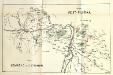
Stolice Pešť-Pilišská. Stolice Komárno a Ostřihom
Komitat Komárom-Esztergom, Komitat Pest-Pilis-Solt-Kiskun, ethnische Gruppe
Serben im Komitat Pest 1980
Komitat Pest Serben, Siedlung Bottlik, Zsolt
C. Pestensis
Ungarn Komitat Pest
Serben im Komitat Pest 1880
Komitat Pest Serben, Siedlung Bottlik, Zsolt
Serben im Komitat Pest 1941
Komitat Pest Serben, Siedlung Bottlik, Zsolt
A szerbek aránya és száma Pest megyében 1880-ban
Komitat Pest Serben, Siedlung Bottlik, Zsolt
A szerbek aránya és száma Pest megyében 1941-ben
Komitat Pest Serben, Siedlung Bottlik, Zsolt

A szerbek aránya és száma Pest megyében 1980-ban
Komitat Pest Serben, Siedlung Bottlik, Zsolt
Generalkarte von Zentraleuropa
Neubertova generální automapa Republiky československé
1 : 200000 Debrecín (Maďarsko : oblast) Soukup, Jan V. Neubert a synové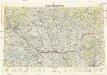
Neubertova generální automapa Republiky československé
1 : 200000 Bratislava (Slovensko : oblast) Soukup, Jan V. Neubert a synové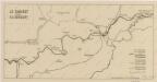
Sbírka map a diagramů použitých na mírových konferencích v Paříži v letech 1919 - 1920
Sbírka map a diagramů použitých na mírových konferencích v Paříži v letech 1919 - 1920

Pest-Pilis-Solt-Kiskun vármegye
1 : 500000 Budapešť (Maďarsko : oblast) Kogutowicz, Manó Magyar Földrajzi Intézet
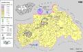
Siedlungsgebiet der Deutschen nach dem Nachbarschaftsindex für Mittel-Transdanubien 1980
Ungarn, Zentralungarn, Deutsche, Siedlung Bottlik, Zsolt
Freytag & Berndt ́s: Auto-Strassenkarten


