Maps of Ukraine

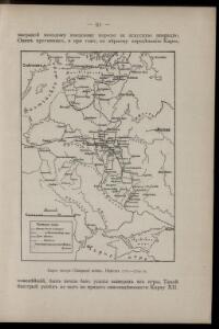
Karta teatra Sěvernoj vojny. Perīod 1707 - 1709 gg.
Russland Nordischer Krieg <1700-1721>
Poland.
from New & accurate description of the earth in all its empires, kingdoms and states
Übersicht des österrechisch-russischen Kriegsschauplatzes

Osteuropa um das Jahr 1250
Osteuropa
Osteuropa beim Regierungsantritte Peters des Gr. 1682
Osteuropa Peter I., Russland, Zar
Osteuropa beim Regierungsantritte Peters des Gr. 1682
Osteuropa Peter I., Russland, Zar
Osteuropa um das Jahr 1250
Osteuropa
Russie occidentale, Pologne.
1 : 4060000 Picquet, C.
Ukraine - Franken : heutige administrative Grenzen
Ukraine, Franken, Verwaltungsgliederung Scheidig, Holger
[Octava Europe tabula] [Karte], in: Clavdii Ptholomei Viri Alexandrini Cosmographie, S. 152.
1 Karte aus Atlas Nicolaus Germanus [und Ptolemaeus, Claudius]
Osteuropa 2003
Osteuropa Kunz, Andreas ; Treiling, Thomas ; Moeschl, Joachim Robert
Raab's Karte der Eisenbahnen Russland's
1 : 4750000 Evropa východní Raab, G. F. Carl Flemming
Karte von Polen und den ehemals dazu gehörigen Provinzen
1 : 8200000 Bělorusko Sotzmann, Daniel Friedrich von D.F. Sotzmann
Osteuropa 1937
Osteuropa Kunz, Andreas ; Treiling, Thomas ; Moeschl, Joachim Robert
Osteuropa 1795
Osteuropa Kunz, Andreas ; Treiling, Thomas ; Moeschl, Joachim Robert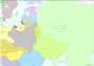
Osteuropa 1921
Osteuropa Kunz, Andreas ; Treiling, Thomas ; Moeschl, Joachim Robert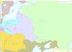
Osteuropa 1772
Osteuropa Kunz, Andreas ; Treiling, Thomas ; Moeschl, Joachim Robert
Osteuropa 1878
Osteuropa Kunz, Andreas ; Treiling, Thomas ; Moeschl, Joachim Robert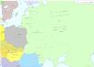
Osteuropa 1949
Osteuropa Kunz, Andreas ; Treiling, Thomas ; Moeschl, Joachim Robert
Russie occidentale, Pologne.
1 : 4060000 Brue, Adrien Hubert, 1786-1832
Slovanský zeměvid
Evropa Šafařík, Pavel Josef Merklas, Václav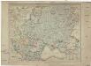
Slovanský zeměvid
Evropa Šafařík, Pavel Josef Merklas, Václav
Slovanský zeměvid
1 : 4530000 Evropa Šafařík, Pavel Josef Merklas, Václav
Slovanský zeměvid
Evropa Šafařík, Pavel Josef Merklas, Václav
Slovanský zeměvid
Evropa Šafařík, Pavel Josef Merklas, Václav
Slovanský zeměvid
Evropa Šafařík, Pavel Josef Merklas, Václav
Slovanský zeměvid
Evropa Šafařík, Pavel Josef Merklas, Václav
Slovanský zeměvid
Evropa Šafařík, Pavel Josef Merklas, Václav
Slovanský zeměvid
1 : 4530000 Evropa Šafařík, Pavel Josef Merklas, Václav
Slovanský zeměvid
1 : 4530000 Evropa Šafařík, Pavel Josef Merklas, Václav
Slovanský zeměvid
1 : 4530000 Evropa Šafařík, Pavel Josef Merklas, Václav
Slovanský zeměvid
Evropa Šafařík, Pavel Josef Merklas, Václav
Slovanský zeměvid
Evropa Šafařík, Pavel Josef Merklas, Václav
Slovanský zeměvid
Evropa Šafařík, Pavel Josef Merklas, Václav