Maps of Pontic Steppe

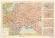
Osteuropa beim Regierungsantritte Peters des Gr. 1682
Osteuropa Peter I., Russland, Zar
Osteuropa beim Regierungsantritte Peters des Gr. 1682
Osteuropa Peter I., Russland, Zar
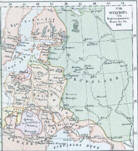
Osteuropa um das Jahr 1250
Osteuropa
Osteuropa um das Jahr 1250
Osteuropa
Composite: Sheets 1 - 16 Kriegsstrassen Karte eines Theiles von Russland
1 : 1400000 Schubert, Friedrich Theodor
Poland.
from New & accurate description of the earth in all its empires, kingdoms and states
Raab's Karte der Eisenbahnen Russland's
1 : 4750000 Evropa východní Raab, G. F. Carl Flemming
20. Nord u. Ost-Europa im Jahre 1310
Nordeuropa, Osteuropa
Russland von der Zerstörung Kiews durch Batu, 1240, bis zum Übergang des Grossfürstenthums nach Moskau
1 : 15000000 Russland
Das europaische Russland
1 : 6588000 Petrohrad-oblast (Rusko) Weiland, Karl Ferdinand im Verlage des Geogr. Instituts
Das europaeische Russland
1 : 6588000 Petrohrad-oblast (Rusko) Weiland, Karl Ferdinand im Verlage des Geogr. Instituts
Das europaeische Russland
1 : 6588000 Rusko západní Weiland, Karl Ferdinand Geograph. Institut
Russland nach seinen kirchlichen Verhältnissen bis zum XVI. Jahrhundert
1 : 15000000 Russland Kirchengeschichte
Sarmatia.
1 : 22000000 Fenner, Rest.
Ethnographische Übersichtskarte von Osteuropa
1 : 10000000 Russland Ukraine Ethnische Gruppe Kartogr. Anstalt G. Freytag & Berndt, Ges. m. b. H., Wien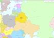
Osteuropa 2003
Osteuropa Kunz, Andreas ; Treiling, Thomas ; Moeschl, Joachim Robert
Das europaeische Russland
1 : 7000000 Rusko západní Weiland, Karl Ferdinand Maedel, C.J. im Verlage des Geogr. Instituts
Russland von der Besiegung der Petschenegen durch die Polowzer und der Erweiterung der Nowgorodischen Republik nach Nordosten, um 1114 bis zur Zerstörung Kiew's durch die Tataren 1240
1 : 12000000 Weliki Nowgorod, Kiewer Reich
Tabula Europae VIII. [Karte], in: Geographia universalis vetus et nova complectens Claudii Ptolemaei Alexandrini enarrationis libros VIII, S. 245.
1 Karte aus Atlas Münster, Sebastian [und Ptolemaeus, Claudius]
Karta želěznych dorog Rossijskoj imperiji
1 : 1200000 Moskva-oblast (Rusko) izdanije Kartografičeskago zavedenija A. Il'jina
Uebersicht über die Stabsquartiere der russischen Armee
Russland Militär
Russland um das Jahr 962
1 : 21000000 Russland
[Neuer Atlas der ganzen Erde nach den neuesten Bestimmungen ... : XXII.] Charte von dem Europaeisch-Russischen Reiche
Entworfen u. gezeichnet von Dr. F.W. Streit H. Leutemann sc. Leipzig : J.C. Hinrichssche Buchhandlung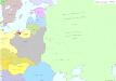
Osteuropa 1937
Osteuropa Kunz, Andreas ; Treiling, Thomas ; Moeschl, Joachim Robert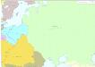
Osteuropa 1795
Osteuropa Kunz, Andreas ; Treiling, Thomas ; Moeschl, Joachim Robert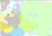
Osteuropa 1921
Osteuropa Kunz, Andreas ; Treiling, Thomas ; Moeschl, Joachim Robert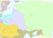
Osteuropa 1772
Osteuropa Kunz, Andreas ; Treiling, Thomas ; Moeschl, Joachim Robert
Osteuropa 1878
Osteuropa Kunz, Andreas ; Treiling, Thomas ; Moeschl, Joachim Robert
Russia, Poland.
1 : 5600000 Arrowsmith, John