Maps of Denmark
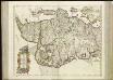
[65][65] Lutiae tabula ..., uit: Atlas sive Descriptio terrarum orbis
Annotatie: Gedigitaliseerde versie. Amsterdam. Heiloo : Picturae (vervaardiger), 2015. tiff-bestand. Gedigitaliseerd: 07-01-2015; Origineel: Universiteitsbibliotheek Vrije Universiteit (XL.05127.-) ; Netherlands; Titelpagina ontbreekt Wit, Frederik de Amsterdam : Frederick de Wit
Jütland
1 : 480000 Jutský poloostrov (Dánsko a Německo) C. Flemming
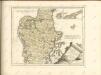

Composite: Jutland.
1 : 480000 Flemming, Carl
Jütland

IVTIA, | olim | CIMBRICA | CHERSONESVS.
[Amsterdam : Joan Blaeu]
Tabula generalis Iutiae
1 : 470000 Dánsko Homann, Johann Baptist J. B. Homann
Special-Karte von Jütland im Maassstabe 1:400.000
1 : 400000 Jutský poloostrov (Dánsko a Německo) Petermann, August Justus Perthes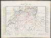
Iutiae Septentrionalis [Karte], in: Gerardi Mercatoris et I. Hondii Newer Atlas, oder, Grosses Weltbuch, Bd. 1, S. 106.
1 Karte aus Atlas Mercator, Gerhard und Hondius, Jodocus Jansson, Jan
Iutia Septentrionalis [Karte], in: Atlas, sive, Cosmographicae meditationes de fabrica mundi et fabricati figura, S. 138.
1 Karte aus Atlas Mercator, Gerhard
Iutia Septentrionalis [Karte], in: Gerardi Mercatoris Atlas, sive, Cosmographicae meditationes de fabrica mundi et fabricati figura, S. 143.
1 Karte aus Atlas Mercator, Gerhard Montanus, Petrus
Jutia Australis, in qua Dioeceses Ripensis et Arhusiensis. [Karte], in: Novus atlas absolutissimus, Bd. 1, S. 140.
1 Karte aus Atlas Janssonius Offizin
Jutia Septentrionalis, in qua Dioeceses Alburgensis et Viburgensis. [Karte], in: Novus atlas absolutissimus, Bd. 1, S. 137.
1 Karte aus Atlas Janssonius Offizin
PARS BOREALIOR | IVTIÆ SEPTENTRIONALIS, | in qua DIOECESES | ALBVRGENSIS | et | VIBVRGENSIS.
[Amsterdam : Joan Blaeu]
PARS AVSTRALIOR | IVTIÆ SEPTENTRIONALIS, | in qua DIOECESES | RIPENSIS | et | ARHVSIENSIS.
[Amsterdam : Joan Blaeu]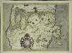
Ivtia septentrionalis
1 Karte : Kupferdruck ; 27 x 38 cm Mercator; Hondius Henricus Hondius
Jutland I.
1 : 480000 Flemming, Carl
Jutland II.
1 : 480000 Berghaus, Heinrich; Flemming, Carl; Sohr, Karl
Frederica 2, uit: Special-Karte von Mittel-Europa / nach amtlichen Quellen bearbeitet von W. Liebenow
1 : 300000 titelvariant: W. Liebenow's Mittel-Europa; Annotatie: Titel boven de bladen: W. Liebenow's Mittel-Europa Johannes Wilhelm Liebenow 1822-1897 Frankfurt a. M. : Ludwig Ravenstein
Ringkjöbing 1, uit: Special-Karte von Mittel-Europa / nach amtlichen Quellen bearbeitet von W. Liebenow
1 : 300000 titelvariant: W. Liebenow's Mittel-Europa; Annotatie: Titel boven de bladen: W. Liebenow's Mittel-Europa Johannes Wilhelm Liebenow 1822-1897 Frankfurt a. M. : Ludwig Ravenstein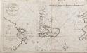
Netto afteekening van de Bay van Ebeltuds Wyk en het eyland Sampsoen in't groot
Denmark Johannes van Keulen
Fionia
1 Karte : Kupferdruck ; 34 x 38 cm Mercator; Hondius Henricus Hondius
Fionia [Karte], in: Gerardi Mercatoris et I. Hondii Newer Atlas, oder, Grosses Weltbuch, Bd. 1, S. 112.
1 Karte aus Atlas Mercator, Gerhard und Hondius, Jodocus Jansson, Jan
Ducatus Slesvicensis Pars Septentrionalis. [Karte], in: Novus atlas absolutissimus, Bd. 1, S. 158.
1 Karte aus Atlas Janssonius Offizin
DVCATVS | SLESWICI | PARS BOREALIS.
Matthias und Nicolaus Pet. | Goldtschmide gebr. Hus. sculp. [Amsterdam : Joan Blaeu]

Kolding nach der Schlacht

Topographische Karte der Umgegend von Fredericia
1 : 160000 Fredericia (Dánsko) C. Flemming
![[65][65] Lutiae tabula ..., uit: Atlas sive Descriptio terrarum orbis](https://images-2.georeferencer.com/images/iiif/578032210023/full/,300/0/native.jpg)

