Maps of Tønder Municipality

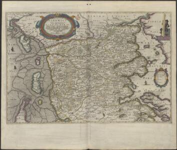
DVCATVS | SLESWICI | PARS BOREALIS.
Matthias und Nicolaus Pet. | Goldtschmide gebr. Hus. sculp. [Amsterdam : Joan Blaeu]
Ducatus Slesvicensis Pars Septentrionalis. [Karte], in: Novus atlas absolutissimus, Bd. 1, S. 158.
1 Karte aus Atlas Janssonius Offizin
PARS OCCIDENTALIS | PRÆFECTVRÆ | HADERSLEBEN | cum adjacentibus | RIPEN et LOHMCLOSTER | PRÆFECTVRIS.
Matthias Vnd Clauss Petersen | Goldtschmide gebr. Husumens. sculps. [Amsterdam : Joan Blaeu]
Special-Karte von Nord-Schleswig im Maassstabe 1:150.000
1 : 150000 Fredericia (Dánsko) Petermann, August Justus Perthes
Special-Karte von Nord-Schleswig im Maassstabe 1:150.000
1 : 150000 Fredericia (Dánsko) Petermann, August Friedrich Ehrlich
3. Lügumkloster, uit: Topographische Uebersichtskarte des Deutschen Reiches / herausgegeben v. d. Kartogr. Abt. d. Königl. Preuß. Landesaufnahme
1 : 200000 titelvariant: Topogr. Übersichtskarte des Deutschen Reiches; Annotatie: Titel boven bladen ook: Topogr. Übersichtskarte des Deutschen Reiches; Annotatie geografische gegevens: Op elk blad twee maatstokken: 10 Kilometer = 5,5 cm; 1 geogr. Meile = 3,6 cm; Legenda onder op elk blad Königlich Preußische Landesaufnahme. Kartographische Abtheilung [S.l : Königlich Preußische Landesaufnahme, Kartographische Abtheilung]
PARS ORIENTALIS | PRÆFECTVRÆ | HADERSLEBEN | Vulgo dictæ Baringsijßel.
Matthias Vnd Clauss Petersen | G.S. gebr. | Husumenss. sculps. [Amsterdam : Joan Blaeu]
4. Hadersleben (papieren versie, niet op linnen), uit: Topographische Uebersichtskarte des Deutschen Reiches / herausgegeben v. d. Kartogr. Abt. d. Königl. Preuß. Landesaufnahme
1 : 200000 titelvariant: Topogr. Übersichtskarte des Deutschen Reiches; Annotatie: Titel boven bladen ook: Topogr. Übersichtskarte des Deutschen Reiches; Annotatie geografische gegevens: Op elk blad twee maatstokken: 10 Kilometer = 5,5 cm; 1 geogr. Meile = 3,6 cm; Legenda onder op elk blad Königlich Preußische Landesaufnahme. Kartographische Abtheilung [S.l : Königlich Preußische Landesaufnahme, Kartographische Abtheilung]
4. hadersleben, uit: Topographische Uebersichtskarte des Deutschen Reiches / herausgegeben v. d. Kartogr. Abt. d. Königl. Preuß. Landesaufnahme
1 : 200000 titelvariant: Topogr. Übersichtskarte des Deutschen Reiches; Annotatie: Titel boven bladen ook: Topogr. Übersichtskarte des Deutschen Reiches; Annotatie geografische gegevens: Op elk blad twee maatstokken: 10 Kilometer = 5,5 cm; 1 geogr. Meile = 3,6 cm; Legenda onder op elk blad Königlich Preußische Landesaufnahme. Kartographische Abtheilung [S.l : Königlich Preußische Landesaufnahme, Kartographische Abtheilung]
Praefectvra Apenrade et Luntoft herde
1 : 95000 Mollova mapová sbírka Mejer, Johannes Rothgiesser, Christian Lorenzen Blaeu, Joan I.
5. Hvidding. (Germany)
1 : 100000 Reichsamt fur Landesaufnahme
Composite: 5. Hvidding. (Germany)
1 : 100000 Reichsamt fur Landesaufnahme
11. Rom. (Germany)
1 : 100000 Reichsamt fur Landesaufnahme
7. Hadersleben. (Germany)
1 : 100000 Reichsamt fur Landesaufnahme
PRÆFECTVRA | APENRADE | et Luntoft herde.
Christian Rothgiesser | Husum. sculpsit. [Amsterdam : Joan Blaeu]
Composite: 7. Hadersleben. (Germany)
1 : 100000 Reichsamt fur Landesaufnahme
Composite: 11. Rom. (Germany)
1 : 100000 Reichsamt fur Landesaufnahme
13. Apenrade. (Germany)
1 : 100000 Reichsamt fur Landesaufnahme
Composite: 13. Apenrade. (Germany)
1 : 100000 Reichsamt fur Landesaufnahme
12. Lugumkloster. (Germany)
1 : 100000 Reichsamt fur Landesaufnahme
Kolding nach der Schlacht

Topographische Karte der Umgegend von Fredericia
1 : 160000 Fredericia (Dánsko) C. Flemming
Composite: 12. Lugumkloster. (Germany)
1 : 100000 Reichsamt fur Landesaufnahme
Messtischblatt 101 : Augustenburg, 1879 Augustenburg
1 : 250000 Augustenburg. - Aufn. 1877. - 1:25000. - [Berlin]: Reichsamt für Landesaufnahme, 1879. - 1 Kt.
Messtischblatt 100 : Sonderburg, 1879 Sonderburg
1 : 250000 Sonderburg. - Aufn. 1877. - 1:25000. - [Berlin]: Reichsamt für Landesaufnahme, 1879. - 1 Kt.
Messtischblatt 99 : Gravenstein, 1879 Gravenstein
1 : 250000 Gravenstein. - Aufn. 1877. - 1:25000. - [Berlin]: Reichsamt für Landesaufnahme, 1879. - 1 Kt.
Messtischblatt 98 : Klippleff,1879 Klipleff
1 : 250000 Klipleff. - Aufn. 1877. - 1:25000. - [Berlin]: Reichsamt für Landesaufnahme, 1879. - 1 Kt.
Messtischblatt 97 : Tingleff, 1914 Tingleff
1 : 250000 Tingleff. - Aufn. 1878, hrsg. 1880, Auflagedr. 1914.. - 1:25000. - [Berlin]: Reichsamt für Landesaufnahme, 1914. - 1 Kt.
Messtischblatt 96 : Bülderup, 1880 Bülderup
1 : 250000 Bülderup. - Aufn. 1878. - 1:25000. - [Berlin]: Reichsamt für Landesaufnahme, 1880. - 1 Kt.