Maps of Friesland
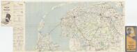
[Kaart], uit: Groningen - Alkmaar
1 : 200000 Annotatie: Omslagtitel; Annotatie geografische gegevens: Legenda in het Frans, Engels en Nederlands Amsterdam : Nederlandsche Bandenindustrie Michelin
[Kaart], uit: [Noord-Nederland] / Topografische Dienst
1 : 200000 Topografische Dienst ['s-Gravenhage : Topografische Dienst]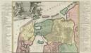
Descriptio Frisiae Liberae inter Kinnemum et Amisiam sub Francorum reditum usq; ad eluviones seculi XIII.
1 : 590000 Mollova mapová sbírka Alting, Menso Broen, Gerrit de
Frisia occidentalis. [Karte], in: Gerardi Mercatoris Atlas, sive, Cosmographicae meditationes de fabrica mundi et fabricati figura, S. 334.
1 Karte aus Atlas Mercator, Gerhard Montanus, Petrus
[Kaart], uit: N.O. Nederland
1 : 300000 titelvariant: Groningen, Friesland en Drente; Ten Brink's reiskaart van Groningen, Friesland en Drente; Annotatie: Titel linksonder: Groningen, Friesland en Drente; Omslagtitel: Ten Brink's reiskaart van Groningen, Friesland en Drente : voornamelijk ten dienste van motor-, auto- en wielrijders en voor kantoor en op reis Arnhem : Ten Brink

Frisia Occidentalis
1 : 300000 Sibrandus Leonis Leovardiensis describ. [Antwerpen] : [Abraham Ortelius]
DOMINII FRISIAE tabula, inter FLEVUM et LAVICAM
1 : 150000 Frísko Schotanus, Bernhard Visscher, Nicolaes Jansz. ex officina Nicolai Visscher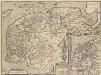
Frisia Occidentalis. [Karte] Antiquae Frisiae situs sub Augusto Imperatore, ut fertur. [Nebenkarten], in: Theatrum orbis terrarum, S. 198.
1 Karte aus Atlas Ortelius, Abraham Vrients, Jan Baptista
Frisiae occidentalis typus.
1 : 400000 [Cornelis Claesz.] [Amsterdam] : [Johannes Janssonius]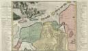
Pars II. et III. Frisiae Libera à Flevo in Lavicam quae Osteresia, atque hinc in Amisiam, quae Groningana cum Transvechtana Dicione Episcopatus Trajectini. Post eluviones seculi XIII
1 : 550000 Mollova mapová sbírka Alting, Menso
Frisia Occidentalis [Karte], in: Novus Atlas, das ist, Weltbeschreibung, Bd. 1, S. 411.
1 Karte aus Atlas Blaeu, Joan Blaeu, Willem Janszoon
Frisia Occidentalis [Karte], in: Le théâtre du monde, ou, Nouvel atlas contenant les chartes et descriptions de tous les païs de la terre, Bd. 1, S. 444.
1 Karte aus Atlas Blaeu, Willem Janszoon und Blaeu, Joan Blaeu, Willem Janszoon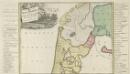
Pars I. Frisiae Liberae quae Westfresia Post eluviones seculi XIII.
1 : 370000 Mollova mapová sbírka Alting, Menso Broen, Gerrit de
Frisia Occidentalis [Karte], in: Theatrum orbis terrarum, sive, Atlas novus, Bd. 1, S. 442.
1 Karte aus Atlas Blaeu, Joan Blaeu, Willem Janszoon
Nieuwe kaart van het departement van de Eems, verdeeld in VII ringen
1 : 480000 C. Covens del. C. van Baarsel sculp. Te Amsterdam : bij Mortier Covens en Zoon
Paskaarte van de Zuyder Zee met alle des zelfs inkomende gaaten, soo als die op't zeekerts konnen bezeyld worden: naa haare correkte course, opdoeningen, droogten en diepten
1 : 200000 Tot Amsterdam : by Joannis van Keulen
Domini Frisiae
1 : 150000 Mollova mapová sbírka Schenk, Peter II
Illustribus et Potentibus Frisiae
Mollova mapová sbírka Geelkerken, Nicolaas van Wit, Frederick
Frisia Occidentalis
1 : 240000 Mollova mapová sbírka Merian, Caspar Merian, Caspar
La Seigneurie D'Ouest-Frise ou Frise Occidentale, divisée en ses Trois Parties, subdiviseés en leurs Iuridictions. [Karte], in: Atlas nouveau, contenant toutes les parties du monde [...], Bd. 2, S. 89.
1 Karte aus Atlas Sanson, Nicolas Jaillot, Alexis Hubert und Mortier, Pieter
[7], uit: Hydro-Oro und Chorographische General Karte des Koenigreichs der Niederlande und der angrenzenden Länder bis Paris : mit der Angabe der Kunst und Heer-Strassen und der Entfernung der Poststationen / ... zusammengetragen und reducirt von ... Wilhelm Müller
1 : 400000 titelvariant: Generalkarte des Koenigreichs Hannover; Annotatie: 1e supplement bij: Generalkarte des Koenigreichs Hannover (1818) Müller, Wilhelm (fl. 1818) [Hannover : Wilhelm Müller]
FRISIA | OCCIDENTALIS
Adriano Metio et Gerardo Freitag | Auctoribus, [Amsterdam : Joan Blaeu]
FRISIA | OCCIDENTALIS
Adriano Metio et Gerardo Freitag | Auctoribus [Amsterdam : Joan Blaeu]
La Seignevrie d'Ovest-Frise ou Frise Occidentale
1 : 230000 Mollova mapová sbírka Sanson, Guillaume Jaillot, Alexis Hubert
Frisia Occidentalis [Karte], in: Novus atlas absolutissimus, Bd. 3, S. 217.
1 Karte aus Atlas Janssonius Offizin
Frisia Occidentalis [Karte], in: Gerardi Mercatoris et I. Hondii Newer Atlas, oder, Grosses Weltbuch, Bd. 1, S. 472.
1 Karte aus Atlas Mercator, Gerhard und Hondius, Jodocus Jansson, Jan
Tabula comitatus Frisiae
1 : 300000 Frísko Schotanus, Bernhard Wit, Frederick de a Frederico de Witt
![[Kaart], uit: Groningen - Alkmaar](https://images-2.georeferencer.com/images/iiif/371981656024/full/,300/0/native.jpg)

