Maps of okres Strakonice

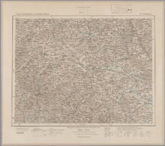
166. Hirschbach, uit: Topographische Uebersichtskarte des Deutschen Reiches / herausgegeben v. d. Kartogr. Abt. d. Königl. Preuß. Landesaufnahme
1 : 200000 titelvariant: Topogr. Übersichtskarte des Deutschen Reiches; Annotatie: Titel boven bladen ook: Topogr. Übersichtskarte des Deutschen Reiches; Annotatie geografische gegevens: Op elk blad twee maatstokken: 10 Kilometer = 5,5 cm; 1 geogr. Meile = 3,6 cm; Legenda onder op elk blad Königlich Preußische Landesaufnahme. Kartographische Abtheilung [S.l : Königlich Preußische Landesaufnahme, Kartographische Abtheilung]
Prachiner Kreis

Prachenský kraj w králowstwí českém
1 : 145000 Jihočeský kraj (Česko) Loth, Johann Schönfelder, Franz von Friedrich Kretzschmar
Müllerova mapa Čech
1 : 132000
Provincia Prachensis
1 : 233000 Mollova mapová sbírka Erber, Bernardinus Winkler, Johann Christoph Kurzböck, Josef von
Prachiner Kreis
Prácheňsko (Česko) Berndt, Johann Christoph
[Prachiner Kreis]
Prácheňsko (Česko) Berndt, Johann Christoph
Prachiner Kreis
Prácheňsko (Česko) Berndt, Johann Christoph
Prachiner Kreis
Prácheňsko (Česko) Berndt, Johann Christoph
Prachiner Kreis
Prácheňsko (Česko) Berndt, Johann Christoph
II. vojenské mapování 30
1 : 144000
Generální mapa okresního hejtmanství Strakonického
1 : 220000 Strakonice-oblast (Česko) Wagner, Jan Eduard F. Kytka
Podrobná mapa Šumavy
1 : 100000 Horažďovice (Česko : oblast) Srp, Jan Jos. R. Vilímek
Generální mapa okresního hejtmanství Píseckého
1 : 220000 Písek-oblast (Česko) Wagner, Jan Eduard Štumper, Karel J. Šváb
Generální mapa okresního hejtmanství Píseckého
1 : 220000 Písek-oblast (Česko) Wagner, Jan Eduard F. Kytka
Generální mapa okresního hejtmanství Píseckého
1 : 220000 Písek-oblast (Česko) Wagner, Jan Eduard F. Kytka
Generální mapa okresního hejtmanství Píseckého
1 : 220000 Písek-oblast (Česko) Wagner, Jan Eduard F. Kytka
Podrobná místopisná mapa Království Českého
Podrobná místopisná mapa Království Českého

Podrobná mapa Království českého
1 : 100000 Písek (Česko : oblast) Srp, Jan Jaroslav Bursík
Vilímkovy místopisné mapy zemí Koruny české
1 : 100000 Písek (Česko : oblast) Srp, Jan Jos. R. Vilímek
III. vojenské mapování 4351
1 : 75000
Pisek und Blatna.
from Spezialkarte der osterreichisch-ungarischen Monarchie.
Generální mapa okresních hejtmanství

Nepomuk und Horazdowitz.
from Spezialkarte der osterreichisch-ungarischen Monarchie.
Protiwin und Prachatitz.
from Spezialkarte der osterreichisch-ungarischen Monarchie.
Schuttenhofen und Winterberg.
from Spezialkarte der osterreichisch-ungarischen Monarchie.
Mapa politického a školního okresu PíseckoOkresní školní výbor v Písku
Okresní školní výbor v Písku
Generální mapa okresních hejtmanství