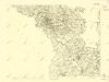
Maps of Landkreis Hof

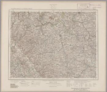
142. Plauen (bijgeschreven: Löbenstein), uit: Topographische Uebersichtskarte des Deutschen Reiches / herausgegeben v. d. Kartogr. Abt. d. Königl. Preuß. Landesaufnahme
1 : 200000 titelvariant: Topogr. Übersichtskarte des Deutschen Reiches; Annotatie: Titel boven bladen ook: Topogr. Übersichtskarte des Deutschen Reiches; Annotatie geografische gegevens: Op elk blad twee maatstokken: 10 Kilometer = 5,5 cm; 1 geogr. Meile = 3,6 cm; Legenda onder op elk blad Königlich Preußische Landesaufnahme. Kartographische Abtheilung [S.l : Königlich Preußische Landesaufnahme, Kartographische Abtheilung]
Aš
1 : 75000 Aš (Česko : oblast) Vojenský zeměpisný ústav
Aš
1 : 75000 Aš-oblast (Česko) Vojenský zeměpisný ústav
Rossbach in Bohmen und Oelsnitz (Im Sachsen).
from Spezialkarte der osterreichisch-ungarischen Monarchie.
Asch.
from Spezialkarte der osterreichisch-ungarischen Monarchie.
Accurate Delineation derer Hochgraefl. Reussischen Herrschafften Lobenstein und Ebersdorff nebst der Pflege Hirschberg
1 : 83000 Schenk, Pieter P. Schenk
III. vojenské mapování 3948
1 : 75000
Asch
1 : 75000 Aš (Česko : oblast) Ansion K. u. k. Militärgeographisches Institut
Asch
1 : 75000 Aš (Česko : oblast) K. u. k. Militärgeographisches Institut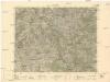
Rossbach
1 : 75000 Aš (Česko : oblast) Vojenský zeměpisný ústav
III. vojenské mapování 3948
1 : 75000
Rossabch in Böhmen und Oelsnitz in Sachsen
1 : 75000 Cheb (Česko : oblast) Maschka K. u. k. militär-geographisches Institut
Rossabch in Böhmen und Oelsnitz in Sachsen
1 : 75000 Cheb (Česko : oblast) Maschka K. u. k. Militärgeographisches Institut
Rossbach in Böhmen und Oelsnitz in Sachsen
1 : 75000 Hranice-oblast (Cheb, Česko) K. u. k. Militärgeographisches Institut
III. vojenské mapování 3848
1 : 75000
Soubor přehledných map pro plánování a statistiku: 3848 – Hranice

Mapy plánování ČSR

Übersichtskarte der Polizeibezirke Culmbach, Stadtsteinach und Weismain im Jahre 1855
1 : 106000 Kirmaier [...] grav. [S.l.] : [s.n.]
Landcharte über die Reichs Adel Zedwizische und der Cron Boeheim zulehen Rührende Herschaft und gütter zu Ascha welche von folgenden possediret werden
Aš-oblast (Česko) Bauer, Joannes Assner, L.
Karte der Bezirke Eger und Asch
1 : 75000 Aš (Česko : oblast) Stelzig, Heinrich J. Kobrtsch & Gschihay
Egerer Vikariat
Cheb-oblast (Česko)

Podrobná mapa Království českého
1 : 100000 Hranice (Cheb, Česko : oblast) Srp, Jan Jos. R. Vilímek
Vilímkovy místopisné mapy zemí Koruny české
1 : 100000 Hranice (Cheb, Česko : oblast) Srp, Jan Jos. R. Vilímek

Podrobná mapa Království českého
1 : 100000 Aš (Česko : oblast) Srp, Jan Jos. R. Vilímek
[Vilímkovy místopisné mapy zemí Koruny české]
1 : 100000 Aš (Česko : oblast) Srp, Jan Jos. R. Vilímek

[Kartenblatt]
1 : 25000 Arzberg (Bavorsko, Německo) Reichsamt für Landesaufnahme