Maps of Aš

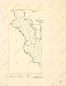
Soubor přehledných map pro plánování a statistiku: 3848 – Hranice

Mapy plánování ČSR
III. vojenské mapování 3948/2
1 : 25000

[Kartenblatt]
1 : 25000 Aš (Česko : oblast) Reichsamt für Landesaufnahme
[Kartenblatt]
1 : 25000 Arzberg (Bavorsko, Německo) Reichsamt für Landesaufnahme
Meßtischblatt 5839 : Haslau, 1941
1 : 250000 Haslau. - Aufn. 1908/1920, hrsg. 1923, erkund. 1937/1939,. - 1:25000. - München, 1941. - 1 Kt.
Meßtischblatt Längenau (Schönberg)
1 : 250000 Längenau (Schönberg). - Aufn. 1920, Ausg. 1923, Nachtr. 1936. - 1:25000. - München, 1936. - 1 Kt.
Meßtischblatt 63 (156) : Längenau (Schönberg), 1933
1 : 250000 Längenau. - 1:25000. - München, 1933. - 1 Kt.
Meßtischblatt 1576 : Schönberg, 1929
1 : 250000 Schönberg. - Umdr.-Ausg., aufgen. 1908, hrsg. 1910, bericht. 1922, Nachtr. 1926. - 1:25000. - Leipzig, 1929. - 1 Kt.
Meßtischblatt 156 : Schönberg, 1922
1 : 250000 Schönberg. - Aufgen. 1908, hrsg. 1910, kurrentgest. 1922. - 1:25000. - Leipzig, 1922. - 1 Kt.
Meßtischblatt 156 : Schönberg, 1919
1 : 250000 Schönberg. - Aufgen. 1908, hrsg. 1910, einz. Nachtr. 1919. - 1:25000. - Leipzig, 1919. - 1 Kt.
Meßtischblatt 154 : Bad-Elster (Wildenau), 1933
1 : 250000 Bad-Elster (Wildenau). - Umdr.-Ausg., aufgen. 1908, hrsg. 1910, bericht. 1920, Nachtr. 1933. - 1:25000. - Leipzig, 1933. - 1 Kt.
Meßtischblatt 154 : Bad-Elster, 1922
1 : 250000 Bad-Elster. - Aufgen. 1908, hrsg. 1910, kurrentgest. 1920, einz. Nachtr. 1922. - 1:25000. - Leipzig, 1922. - 1 Kt.
Meßtischblatt 154 : Bad Elster, 1920
1 : 250000 Bad Elster. - Aufgen. 1908, hrsg. 1910, kurrentgest. 1920. - 1:25000. - Leipzig, 1920. - 1 Kt.
III. vojenské mapování 3848/4
1 : 25000
III. vojenské mapování 3848/4
1 : 25000
III. vojenské mapování 3948/4
1 : 25000
III. vojenské mapování 3948/4
1 : 25000
[Kartenblatt]
1 : 25000 Doubrava (Aš, Česko) Reichsamt für Landesaufnahme
Gradkartenblatt
1 : 25000 Čechy (Česko) Brzesina, Julius von
Meßtischblatt 83 (5939) : Waldsassen, 1936
1 : 250000 Waldsassen. - Aufn. 1920, Ausg. 1931, Nachträge 1936. - 1:25000. - München, 1936. - 1 Kt.
Asch - c0034-1-009 - Kaiserpflichtexemplar der Landkarten des stabilen Katasters
1 : 2880
Asch - c0034-1-003 - Kaiserpflichtexemplar der Landkarten des stabilen Katasters
1 : 2880
Asch - c0034-1-007 - Kaiserpflichtexemplar der Landkarten des stabilen Katasters
1 : 2880
Asch - c0034-1-002 - Kaiserpflichtexemplar der Landkarten des stabilen Katasters
1 : 2880
Asch - c0034-1-008 - Kaiserpflichtexemplar der Landkarten des stabilen Katasters
1 : 2880
Asch - c0034-1-006 - Kaiserpflichtexemplar der Landkarten des stabilen Katasters
1 : 2880
Asch - c0034-1-005 - Kaiserpflichtexemplar der Landkarten des stabilen Katasters
1 : 2880
Asch - c0034-1-001 - Kaiserpflichtexemplar der Landkarten des stabilen Katasters
1 : 2880