Maps of Plungės rajono savivaldybė

2. Paaschken, uit: Topographische Uebersichtskarte des Deutschen Reiches / herausgegeben v. d. Kartogr. Abt. d. Königl. Preuß. Landesaufnahme
1 : 200000 titelvariant: Topogr. Übersichtskarte des Deutschen Reiches; Annotatie: Titel boven bladen ook: Topogr. Übersichtskarte des Deutschen Reiches; Annotatie geografische gegevens: Op elk blad twee maatstokken: 10 Kilometer = 5,5 cm; 1 geogr. Meile = 3,6 cm; Legenda onder op elk blad Königlich Preußische Landesaufnahme. Kartographische Abtheilung [S.l : Königlich Preußische Landesaufnahme, Kartographische Abtheilung]
Karte des westlichen Russlands K18

Meßtischblatt 0495 : Grünheide b. Wilkieten, 1939
1 : 250000 Grünheide b. Wilkieten. - Hrsg. 1911, red. Änd. 1939. - 1:25000. - [Berlin]: Reichsamt für Landesaufnahme, 1939. - 1 Kt.
Messtischblatt 0494 : Wilkieten, 1936 Wilkieten
1 : 250000 Wilkieten. - Aufn. 1910.. - 1:25000. - [Berlin]: Reichsamt für Landesaufnahme, 1912. - 1 Kt.
Messtischblatt 0394 : Dawillen, 1939 Dawillen
1 : 250000 Dawillen. - Hrsg. 1911, red. Änd. 1939. - 1:25000. - [Berlin]: Reichsamt für Landesaufnahme, 1939. - 1 Kt.
Messtischblatt 294 : Laugallen, 1940 Laugallen
1 : 250000 Laugallen. - Aufnahme 1910, redakt. Änd. 1940, hrsg. 1911.. - 1:25000. - [Berlin]: Reichsamt für Landesaufnahme, 1940. - 1 Kt.
Messtischblatt 194 : Jakubowo, 1940 Jakubowo
1 : 250000 Jakubowo. - Hrsg. 1911, vorläuf. Ausg. 1940. - 1:25000. - [Berlin]: Reichsamt für Landesaufnahme, 1940. - 1 Kt.
Sect. 2. Memel (Das Curische Haff nördl. Theil), uit: Geologische Karte der Provinz Preussen
1 : 100000 Annotatie: Incompleet; Voor aanwezige bladen zie bladoverzicht; Met inzetkaarten; Annotatie geografische gegevens: Coördinaten gebaseerd op nulmeridiaan van Ferro (Hierro) Berlin : Neumann
[Umgebungsplan Memel]
1 : 300000 Litauen Ostpreußen Memel Umland
Composite: 2. (1. Crottingen) Schlattern. (Germany)
1 : 100000 Reichsamt fur Landesaufnahme
2. (1. Crottingen) Schlattern. (Germany)
1 : 100000 Reichsamt fur Landesaufnahme

Potentissimo BORUSSORUM REGI FRIDERICO WILHELMO, Majestate, Fortitudine Clementia Augustissimo
1 : 200000 Kaliningrad-oblast (Rusko) Betgen, Johann F. Homanniani Heredes
Dvcatvs Cvrlandiæ jux.ta Barnikelii architecti curici primarii geometricam delineationem geographica tabula expressus
1 Karte : Kupferdruck ; 47 x 34 cm Barnickel Homännische Erben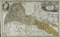
Dvcatvs Cvrlandiæ jux.ta Barnikelii architecti curici primarii geometricam delineationem geographica tabula expressus
1 Karte : Kupferdruck ; 48 x 34 cm Barnickel Homännische Erben
Tilsit 8, uit: Special-Karte von Mittel-Europa / nach amtlichen Quellen bearbeitet von W. Liebenow
1 : 300000 titelvariant: W. Liebenow's Mittel-Europa; Annotatie: Titel boven de bladen: W. Liebenow's Mittel-Europa Johannes Wilhelm Liebenow 1822-1897 Frankfurt a. M. : Ludwig Ravenstein
Ostsee
1 : 150000 Baltské moře Reichs-Marine-Amt
Die Kurische Nehrung und ihre Umgebung
1 : 300000 Russland Litauen Kurische Nehrung Bezzenberger, Adalbert
Composite: 3. Memel. (Germany)
1 : 100000 Reichsamt fur Landesaufnahme
Ostsee
1 : 70000 Baltské moře Reichs-Marine-Amt
3. Memel. (Germany)
1 : 100000 Reichsamt fur Landesaufnahme
Messtischblatt 0493 : Prökuls, 1941 Prökuls
1 : 250000 Prökuls. - Aufn. 1910, hrsg. 1912, letzte Nachtr. 1940. - 1:25000. - [Berlin]: Reichsamt für Landesaufnahme, 1941. - 1 Kt.
Messtischblatt 393 : Götzhöfen, 1940 Götzhöfen
1 : 250000 Götzhöfen. - Aufn. 1910, letzt. Nachtr. 1940, hrsg. 1912.. - 1:25000. - [Berlin]: Reichsamt für Landesaufnahme, 1940. - 1 Kt.
Messtischblatt 293 : Plicken, 1940 Plicken
1 : 250000 Plicken. - Aufnahme 1910, hrsg. 1912, letzte Nachtr. 1940. - 1:25000. - [Berlin]: Reichsamt für Landesaufnahme, 1941. - 1 Kt.
Messtischblatt 0193 : Dtsch. Crottingen, 1940 Dtsch. Crottingen
1 : 250000 Dtsch. Crottingen. - Hrsg. 1912. - 1:25000. - [Berlin]: Reichsamt für Landesaufnahme, 1940. - 1 Kt.
Meßtischblatt 0595 : Berzischken, 1939
1 : 250000 Berzischken. - Hrsg. 1914. - 1:25000. - [Berlin]: Reichsamt für Landesaufnahme, 1939. - 1 Kt.
Meßtischblatt 0594 : Kukoreiten, 1940
1 : 250000 Kukoreiten. - Aufn. 1910, hrsg. 1912, letzter Nachtr. 1940. - 1:25000. - [Berlin]: Reichsamt für Landesaufnahme, 1940. - 1 Kt.
1. Crottingen (2. Schlattern). (Germany)
1 : 100000 Reichsamt fur Landesaufnahme