Maps of Palangos miesto savivaldybė

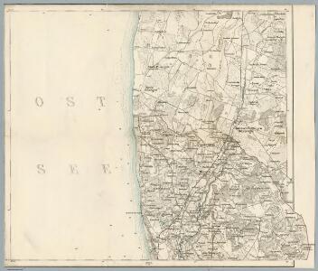
Composite: 2. (1. Crottingen) Schlattern. (Germany)
1 : 100000 Reichsamt fur Landesaufnahme
2. (1. Crottingen) Schlattern. (Germany)
1 : 100000 Reichsamt fur Landesaufnahme
1. Crottingen (2. Schlattern). (Germany)
1 : 100000 Reichsamt fur Landesaufnahme
Messtischblatt 0192 : Nimmersatt, 1939 Nimmersatt
1 : 250000 Nimmersatt. - Hrsg. 1912., redakt. Änd. 1939.. - 1:25000. - [Berlin]: Reichsamt für Landesaufnahme, 1939. - 1 Kt.
Messtischblatt 0193 : Dtsch. Crottingen, 1940 Dtsch. Crottingen
1 : 250000 Dtsch. Crottingen. - Hrsg. 1912. - 1:25000. - [Berlin]: Reichsamt für Landesaufnahme, 1940. - 1 Kt.
Messtischblatt 194 : Jakubowo, 1940 Jakubowo
1 : 250000 Jakubowo. - Hrsg. 1911, vorläuf. Ausg. 1940. - 1:25000. - [Berlin]: Reichsamt für Landesaufnahme, 1940. - 1 Kt.
[Umgebungsplan Memel]
1 : 300000 Litauen Ostpreußen Memel Umland
Messtischblatt 293 : Plicken, 1940 Plicken
1 : 250000 Plicken. - Aufnahme 1910, hrsg. 1912, letzte Nachtr. 1940. - 1:25000. - [Berlin]: Reichsamt für Landesaufnahme, 1941. - 1 Kt.
Messtischblatt 292 : Memel, 1942 Memel
1 : 250000 Memel. - Aufnahme 1910, berichtigt 1940, hrsg. 1912.. - 1:25000. - [Berlin]: Reichsamt für Landesaufnahme, 1942. - 1 Kt.
Messtischblatt 294 : Laugallen, 1940 Laugallen
1 : 250000 Laugallen. - Aufnahme 1910, redakt. Änd. 1940, hrsg. 1911.. - 1:25000. - [Berlin]: Reichsamt für Landesaufnahme, 1940. - 1 Kt.
Ostsee
1 : 150000 Baltské moře Reichs-Marine-Amt
1. Memel, uit: Topographische Uebersichtskarte des Deutschen Reiches / herausgegeben v. d. Kartogr. Abt. d. Königl. Preuß. Landesaufnahme
1 : 200000 titelvariant: Topogr. Übersichtskarte des Deutschen Reiches; Annotatie: Titel boven bladen ook: Topogr. Übersichtskarte des Deutschen Reiches; Annotatie geografische gegevens: Op elk blad twee maatstokken: 10 Kilometer = 5,5 cm; 1 geogr. Meile = 3,6 cm; Legenda onder op elk blad Königlich Preußische Landesaufnahme. Kartographische Abtheilung [S.l : Königlich Preußische Landesaufnahme, Kartographische Abtheilung]
2. Paaschken, uit: Topographische Uebersichtskarte des Deutschen Reiches / herausgegeben v. d. Kartogr. Abt. d. Königl. Preuß. Landesaufnahme
1 : 200000 titelvariant: Topogr. Übersichtskarte des Deutschen Reiches; Annotatie: Titel boven bladen ook: Topogr. Übersichtskarte des Deutschen Reiches; Annotatie geografische gegevens: Op elk blad twee maatstokken: 10 Kilometer = 5,5 cm; 1 geogr. Meile = 3,6 cm; Legenda onder op elk blad Königlich Preußische Landesaufnahme. Kartographische Abtheilung [S.l : Königlich Preußische Landesaufnahme, Kartographische Abtheilung]

Ostsee
1 : 150000 Baltské moře Reichs-Marine-Amt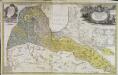
Dvcatvs Cvrlandiæ jux.ta Barnikelii architecti curici primarii geometricam delineationem geographica tabula expressus
1 Karte : Kupferdruck ; 47 x 34 cm Barnickel Homännische Erben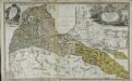
Dvcatvs Cvrlandiæ jux.ta Barnikelii architecti curici primarii geometricam delineationem geographica tabula expressus
1 Karte : Kupferdruck ; 48 x 34 cm Barnickel Homännische Erben
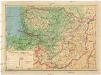
Übersichtskarte von Mittel - Europa

Provinz Ost - Preussen

Riga, Libau, Memel, Kowno
1 : 750000 Kaunas (Litva) K. u. k. Militärgeographisches Institut
Carte des Königreichs Preussen
Suchodoletz, Johann Vladislaus von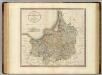
Prussia.
1 : 840000 Cary, John, ca. 1754-1835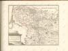
Lietuvos žemelapis
1 : 200000 Litva Spaudos fondas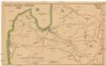
Latwijas dselsszełu schematiska karte
1 : 665000 Lotyšsko Jaunsems, B.
Mappa geographica Borvssiam orientalem aeqve occidentalem exacté exhibens, in qva non tantvm limites correcti, sed etiam principaliora loca, civitates et oppida secvndvm longitvdinem et latitudinem ad am vssim novissimarvm omnistudio et accuratione designata sunt
1 : 698000 Prusko Endersch, Johann Friedrich Ioh. Frideric. Endersch
Prussia.
1 : 1670000 Lucas, Fielding Jr.
Borussiae regnum complectens circulos Sambiensem, Natangiensem et Hockerlandiae nec non Borussia Polonica exhibens palatinatus Culmiensem, Marienburgensem, Pomerelliae et Varmiae cum adjacentibus aliis provinciis
1 : 732000 Prusko Lotter, Tobias Conrad sumtibus et curis exarata Tobiae Conradi Lotteri