Maps of okres Tábor

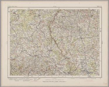
Tabor 117, uit: Special-Karte von Mittel-Europa / nach amtlichen Quellen bearbeitet von W. Liebenow
1 : 300000 titelvariant: W. Liebenow's Mittel-Europa; Annotatie: Titel boven de bladen: W. Liebenow's Mittel-Europa Johannes Wilhelm Liebenow 1822-1897 Frankfurt a. M. : Ludwig Ravenstein
Carte topographique d'Allemagne contenant une partie du royaume de Boheme, savoir les cercles de Beraun, Kaurzin
1 Karte : Kupferdruck ; 46 x 62 cm Jaeger; Facius se vend chez I. W. A. Iaeger
Carte topographique d'Allemagne contenant une partie du Royaume de Boheme
1 : 220000 Jihočeský kraj (Česko) Facius, Johann Gottlieb I. W. A. Iaeger
Regni Bohemiae Circulus Prachinensis
1 : 200000 Prácheňsko (Česko) Müller, Johann Christoph Homannianorum Heredum
Regni Bohemiae Circulus Prachinensis
1 : 200000 Prácheňsko (Česko) Müller, Johann Christoph Homannianorum Heredum
Nová Mapa království Českého
1 : 200000 Čechy jižní (Česko) Kotyška, Václav Hanf, Norbert Bursík & Kohout
[Nová Mapa království Českého]
1 : 200000 Čechy jižní (Česko) Kotyška, Václav Hanf, Norbert Bursík & Kohout
Druhý zařizovací elaborát orlických lesů od Ing. Frant. Jos. Matze, Zámecký revír,kopie, list 2 1

Deutsche Strassenprofilkarte für Radfahre.
Plzeň-oblast (Česko) Scheiner, Josef Mittelbach, R. J.C. Hinrichs
Prachenský kraj w Králowství českém
1 : 140000 Prácheňsko (Česko) Loth, Johann Schönfelder, Franz von Friedrich Kretzschmar
Prachenský kraj w Králowství českém
1 : 140000 Prácheňsko (Česko) Loth, Johann Schönfelder, Franz von Friedrich Kretzschmar
Prachenský kraj w Králowství českém
1 : 140000 Prácheňsko (Česko) Loth, Johann Schönfelder, Franz von Friedrich Kretzschmar
Prachenský kraj w Kralowstwí českém

Regni Bohemiae, Circulus Prachinensis ex Müllerianis...

Prachenský kraj w Kralowstwí českém

Práchenský kraj w králowství Českém

Prachiner Kreis

Prachiner Kreis
1 : 200000 Prácheňsko (Česko) Franza, Petr Peter franza [sic]
Prachiner Kreis
1 : 195000 Písek-oblast (Česko) Franza, Petr Peter franza [sic]
Prachiner Kreis
1 : 195000 Písek-oblast (Česko) Franza, Petr Peter franza [sic]
Prachiner Kreis
1 : 195000 Jihočeský kraj (Česko) Peter Franza
Prachenský kraj w králowstwí českém
1 : 145000 Jihočeský kraj (Česko) Loth, Johann Schönfelder, Franz von Friedrich Kretzschmar
Prachiner Kreis

Mapa hradů, zámků a tvrzí v Písecku a Bechyňsku
1 : 300000 Bechyně (Česko : oblast) Král z Dobré Vody, Vojtěch Šimáček
Mappa geographica regni Bohemiae in duodecim circuloc divisae ... Sectio. XVIII.

Charte vom Prachiner Kreise

Neuester und vollständigster Atlas des Königreiches Böhmen

Special-Karte des Piseker Kreis
1 : 241000 Písek-oblast (Česko) Schmidt, Eduard Wend. Morauer
Special-Karte des Piseker Kreis - resp. politischen Verwaltungsbezirkes im Boehmen
1 : 240000 Písek-oblast (Česko) Schmidt, Eduard Wend. Morauer