Maps of okres Klatovy

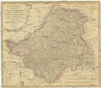
Regni Bohemiae Circulus Prachinensis
1 : 200000 Prácheňsko (Česko) Müller, Johann Christoph Homannianorum Heredum
Regni Bohemiae Circulus Prachinensis
1 : 200000 Prácheňsko (Česko) Müller, Johann Christoph Homannianorum Heredum
Generalkarte von Zentraleuropa

Carte topographique d'Allemagne contenant une partie du royaume de Boheme, savoir les cercles de Beraun, Kaurzin
1 Karte : Kupferdruck ; 46 x 62 cm Jaeger; Facius se vend chez I. W. A. Iaeger
Carte topographique d'Allemagne contenant une partie du Royaume de Boheme
1 : 220000 Jihočeský kraj (Česko) Facius, Johann Gottlieb I. W. A. Iaeger
Tabor 117, uit: Special-Karte von Mittel-Europa / nach amtlichen Quellen bearbeitet von W. Liebenow
1 : 300000 titelvariant: W. Liebenow's Mittel-Europa; Annotatie: Titel boven de bladen: W. Liebenow's Mittel-Europa Johannes Wilhelm Liebenow 1822-1897 Frankfurt a. M. : Ludwig Ravenstein
Südlicher Theil von Boehmen enthaltend den Klatttauer, Berauner, Taborer, Prachiner und Budweiser Kreis
Čechy jižní (Česko) Kindermann, Joseph Karl Kunst= und Industrie Comptoir
Südlicher Theil von Boehmen enthaltend den Klattauer, Berauner, Taborer, Prachiner und Budweiser Kreis
Čechy jižní (Česko) Kindermann, Joseph Karl im Verlage des Kunst- und Industrie Comptoirs
Prachenský kraj w Králowství českém
1 : 140000 Prácheňsko (Česko) Loth, Johann Schönfelder, Franz von Friedrich Kretzschmar
Prachenský kraj w Králowství českém
1 : 140000 Prácheňsko (Česko) Loth, Johann Schönfelder, Franz von Friedrich Kretzschmar
Prachenský kraj w Králowství českém
1 : 140000 Prácheňsko (Česko) Loth, Johann Schönfelder, Franz von Friedrich Kretzschmar
Prachenský kraj w Kralowstwí českém

Prachenský kraj w Kralowstwí českém

Práchenský kraj w králowství Českém

Regni Bohemiae, Circulus Prachinensis ex Müllerianis...

Prachenský kraj w králowstwí českém
1 : 145000 Jihočeský kraj (Česko) Loth, Johann Schönfelder, Franz von Friedrich Kretzschmar
Jihočeský kraj

Charte vom Prachiner Kreise

Prachiner Kreis

Special-Karte des Piseker Kreis
1 : 241000 Písek-oblast (Česko) Schmidt, Eduard Wend. Morauer
Special-Karte des Piseker Kreis - resp. politischen Verwaltungsbezirkes im Boehmen
1 : 240000 Písek-oblast (Česko) Schmidt, Eduard Wend. Morauer
Special-Karte des Piseker Kreis, resp. politischen Verwaltungsbezirkes im Boehmen
1 : 241000 Písek-oblast (Česko) Schmidt, Eduard Wend. Morauer
Kraj Českobudějovický

Neuester und vollständigster Atlas des Königreiches Böhmen

Charte vom Prachiner Kreise des Königreiches Böheim
1 : 241000 Prácheňsko (Česko) Kreibich, František Jakub Jindřich Enders, C. W. C.W. Enders
Charte vom Prachiner Kreise des Königreiches Böheim
1 : 260000 Prácheňsko (Česko) Kreibich, František Jakub Jindřich Pluth, F. C. W. Enders
Charte vom Prachiner Kreise des Königreiches Böheim
1 : 260000 Prácheňsko (Česko) Kreibich, František Jakub Jindřich Pluth, F. C. W. Enders
Charte vom Prachiner Kreise des Königreiches Böheim
1 : 241000 Prácheňsko (Česko) Kreibich, František Jakub Jindřich Enders, C. W. C.W. Enders
Charte vom Prachiner Kreise des Königreiches Böheim
1 : 241000 Prácheňsko (Česko) Kreibich, František Jakub Jindřich Enders, C. W. C.W. Enders
Charte vom Prachiner Kreise des Königreiches Böheim
1 : 241000 Prácheňsko (Česko) Kreibich, František Jakub Jindřich Enders, C. W. C.W. Enders
Charte vom Prachiner Kreise des Königreiches Böheim
1 : 241000 Prácheňsko (Česko) Kreibich, František Jakub Jindřich Enders, C. W. C.W. Enders