Maps of powiat buski

Miechow 93, uit: Special-Karte von Mittel-Europa / nach amtlichen Quellen bearbeitet von W. Liebenow
1 : 300000 titelvariant: W. Liebenow's Mittel-Europa; Annotatie: Titel boven de bladen: W. Liebenow's Mittel-Europa Johannes Wilhelm Liebenow 1822-1897 Frankfurt a. M. : Ludwig Ravenstein
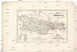
Karta okręgu wolnego miasta Krakowa
1 : 183000 Krakov-oblast (Polsko) Żebrawski, Theofil Friedlein, D. E. nakładem D.E. Friedleina
Karta okręgu wolnego miasta Krakowa
1 : 183000 Krakov-oblast (Polsko) Żebrawski, Theofil Friedlein, D. E. nakładem D.E. Friedleina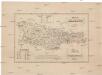
Karta okręgu wolnego miasta Krakowa
1 : 183000 Krakov-oblast (Polsko) Żebrawski, Theofil Friedlein, D. E. nakładem D.E. Friedleina
Ujście Solne
1 : 75000 Polsko Hanel K. u. k. Militärgeographisches Institut
Krakau.
from Spezialkarte der osterreichisch-ungarischen Monarchie.
Nowy Korczyn
1 : 75000 K. u. k. Militärgeographisches Institut
Krakau
1 : 75000 Krakov-oblast (Polsko) Bayer, R. K. u. k. Militärgeographisches Institut
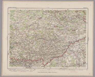
Miechow
1 : 75000 Miechów (Polsko) K. u. k. Militärgeographisches Institut
Ujscie Solne.; Spezialkarte der osterreichisch-ungarischen Monarchie.
from Spezialkarte der osterreichisch-ungarischen Monarchie. Austro-Hungarian Monarchy. Militärgeographisches Institut.,
Pinczow
1 : 75000 K. u. k. Militärgeographisches Institut
Jendrzejów
1 : 75000 K. u. k. Militärgeographisches Institut
Okolice Krakowa
1 : 150000 Krakov-oblast (Polsko) Gustawicz, Bronisław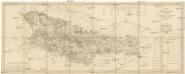
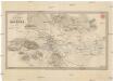
Karte des Gross-Herzogthums Krakau
1 : 114700 Krakov-oblast (Polsko) Liechtenstern, Joseph Marx von Kummersberg, Carl von Julius Wildt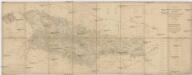
Karte des Gross-Herzogthums Krakau
1 : 114700 Krakov-oblast (Polsko) Liechtenstern, Joseph Marx von Kummersberg, Carl von Julius Wildt
Tarnów und Dąbrowa
1 : 75000 Dąbrowa Tarnowska-oblast (Polsko) Ansion K. u. k. Militärgeographisches Institut
Szczucin.
from Spezialkarte der osterreichisch-ungarischen Monarchie.
Umgebungskarte von Krakau
1 : 75000 Krakov-oblast (Polsko) K. u. k. Militärgeographisches Institut
Szczucin
1 : 75000 Rogulja K. u. k. Militärgeographisches Institut
Staszów
1 : 75000 Staszów (Polsko) K. u. k. Militärgeographisches Institut
Tarnow und Dabrowa.
from Spezialkarte der osterreichisch-ungarischen Monarchie.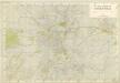
Plan Miasta Krakowa
Plan okolic Krakowa
1 : 36500 Krakov (Polsko) Bach, J. G. nakladem Księgarni D.E. Friedleina
Najnowszy plan stół. król. miasta Krakowa: wykonany przez Bud. Miejs. Odd. B. w Krakowie w roku 1916
Stolecki, Kazimierz
Plan von Krakau mit Podgorze und der nächsten Umgebung
1 : 11200 Krakov-oblast (Polsko) Engel, H. Alexander Koczicka
Plan Krakowa
Krakov (Polsko) Dzieduszycki, Maurycy Szczerbowski
Plan król. stol. miasta Krakowa

Plan miasta Krakowa w orebie okopów
1 : 10000 Krakov (Polsko) Żebrawski, Theofil Friedlein, D. E. nakładem D.E. Friedleina