Maps of powiat goleniowski

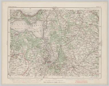
Stettin 36, uit: Special-Karte von Mittel-Europa / nach amtlichen Quellen bearbeitet von W. Liebenow
1 : 300000 titelvariant: W. Liebenow's Mittel-Europa; Annotatie: Titel boven de bladen: W. Liebenow's Mittel-Europa Johannes Wilhelm Liebenow 1822-1897 Frankfurt a. M. : Ludwig Ravenstein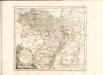

45. Wollin, uit: Topographische Uebersichtskarte des Deutschen Reiches / herausgegeben v. d. Kartogr. Abt. d. Königl. Preuß. Landesaufnahme
1 : 200000 titelvariant: Topogr. Übersichtskarte des Deutschen Reiches; Annotatie: Titel boven bladen ook: Topogr. Übersichtskarte des Deutschen Reiches; Annotatie geografische gegevens: Op elk blad twee maatstokken: 10 Kilometer = 5,5 cm; 1 geogr. Meile = 3,6 cm; Legenda onder op elk blad Königlich Preußische Landesaufnahme. Kartographische Abtheilung [S.l : Königlich Preußische Landesaufnahme, Kartographische Abtheilung]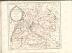

Die Odermündung Swine
1 : 740000 Region Odermündung
Composite: 155. Politz. (Germany)
1 : 100000 Reichsamt fur Landesaufnahme
Composite: 156. Naugard. (Germany)
1 : 100000 Reichsamt fur Landesaufnahme
188. Stargard a. d. Ihna. (Germany)
1 : 100000 Reichsamt fur Landesaufnahme
156. Naugard. (Germany)
1 : 100000 Reichsamt fur Landesaufnahme
Composite: 187. Stettin. (Germany)
1 : 100000 Reichsamt fur Landesaufnahme
186. Prenzlau. (Germany)
1 : 100000 Reichsamt fur Landesaufnahme
Composite: 188. Stargard a. d. Ihna. (Germany)
1 : 100000 Reichsamt fur Landesaufnahme
187. Stettin. (Germany)
1 : 100000 Reichsamt fur Landesaufnahme
Composite: 186. Prenzlau. (Germany)
1 : 100000 Reichsamt fur Landesaufnahme
154. Pasewalk. (Germany)
1 : 100000 Reichsamt fur Landesaufnahme
Composite: 154. Pasewalk. (Germany)
1 : 100000 Reichsamt fur Landesaufnahme
Composite: 121. Swinemunde. (Germany)
1 : 100000 Reichsamt fur Landesaufnahme
121. Swinemunde. (Germany)
1 : 100000 Reichsamt fur Landesaufnahme
122. Wollin. (Germany)
1 : 100000 Reichsamt fur Landesaufnahme
Composite: 122. Wollin. (Germany)
1 : 100000 Reichsamt fur Landesaufnahme
Ostsee
1 : 25000 Odra (řeka : oblast) Reichs-Marine-Amt
Stettin und Umgegend
1 : 370000 Stettin, Umland
Meßtischblatt 2658 : Jacobshagen, 1936
1 : 250000 Jacobshagen. - Hrsg. 1892, bericht. 1936. - 1:25000. - [Berlin]: Reichsamt für Landesaufnahme, 1936. - 1 Kt.
Meßtischblatt 2657 : Marienfließ, 1938
1 : 250000 Marienfließ. - Hrsg. 1891, Nachtr. 1911, redakt. Änd. 1938. - 1:25000. - [Berlin]: Reichsamt für Landesaufnahme, 1938. - 1 Kt.
Meßtischblatt 2656 : Stargard in Pommern, 1922
1 : 250000 Stargard in Pommern. - Hrsg. 1890, bericht. 1922. - 1:25000. - [Berlin]: Reichsamt für Landesaufnahme, 1922. - 1 Kt.
Meßtischblatt 1242 : Kublank, 1906
1 : 250000 Kublank. - Aufn. 1890, hrsg. 1891, gedr. [19]06. - 1:25000. - [Berlin]: Kgl. Preuss. Landesaufnahme, 1906. - 1 Kt.
Meßtischblatt 2654 : Altdamm, 1937
1 : 250000 Altdamm. - Hrsg. 1888, bericht. 1935, einz. Nachtr. 1937. - 1:25000. - [Berlin]: Reichsamt für Landesaufnahme, 1937. - 1 Kt.
Meßtischblatt 1240 : Podejuch, 1907
1 : 250000 Podejuch. - Aufn. 1886, hrsg. 1888, einz. Nachtr. 1907. - 1:25000. - [Berlin]: Reichsamt für Landesaufnahme, 1907. - 1 Kt.