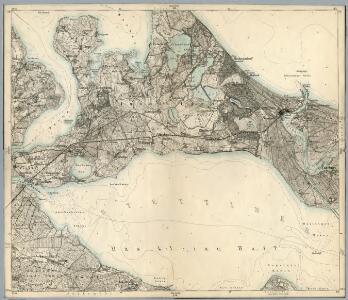
Maps of Usedom-Süd

Composite: 121. Swinemunde. (Germany)
1 : 100000 Reichsamt fur Landesaufnahme
121. Swinemunde. (Germany)
1 : 100000 Reichsamt fur Landesaufnahme
Meßtischblatt 768 : Caseburg, 1911
1 : 250000 Caseburg. - Aufn. 1886, hrsg. 1888, bericht. 1911. - 1:25000. - [Berlin]: Reichsamt für Landesaufnahme, 1911. - 1 Kt.
Meßtischblatt 767 : Zirchow Kr. Usedom-Wollin, 1932
1 : 250000 Zirchow Kr. Usedom-Wollin. - Hrsg. 1887, bericht. 1911, kl. Nachtr. 1927. - 1:25000. - [Berlin]: Reichsamt für Landesaufnahme, 1932. - 1 Kt.
Meßtischblatt 767 : Zirchow Kr. Usedom-Wollin, 1932
1 : 250000 Zirchow Kr. Usedom-Wollin. - Hrsg. 1887, bericht. 1911, kl. Nachtr. 1927. - 1:25000. - [Berlin]: Reichsamt für Landesaufnahme, 1932. - 1 Kt.
Meßtischblatt 766 : Usedom, 1933
1 : 250000 Usedom. - Hrsg. 1887, bericht. 1911, kl. Nachtr. 1925, gedr. [19]33. - 1:25000. - [Berlin]: Reichsamt für Landesaufnahme, 1933. - 1 Kt.
Meßtischblatt 682 : Swinemünde, 1911
1 : 250000 Swinemünde. - Aufn. 1886, hrsg. 1887, bericht. 1911. - 1:25000. - [Berlin]: Reichsamt für Landesaufnahme, 1911. - 1 Kt.
Meßtischblatt 681 : Benz, 1911
1 : 250000 Benz. - Aufn. 1886, hrsg. 1888, bericht. 1911. - 1:25000. - [Berlin]: Reichsamt für Landesaufnahme, 1911. - 1 Kt.
Meßtischblatt Lassan
1 : 250000 Lassan. - Hrsg. 1888, bericht. 1911, einz. Nachtr. 1932. - 1:25000. - [Berlin]: Reichsamt für Landesaufnahme, 1945. - 1 Kt.
Meßtischblatt 680 : Lassan, 1911
1 : 250000 Lassan. - Aufn. 1886, hrsg. 1888, bericht. 1911. - 1:25000. - [Berlin]: Reichsamt für Landesaufnahme, 1911. - 1 Kt.
Meßtischblatt 2251.-52 : Neuwarp, 1925
1 : 250000 Neuwarp. - Hrsg. 1887, bericht. 1911, kl. Nachtr. 1925. - 1:25000. - [Berlin]: Reichsamt für Landesaufnahme, 1925. - 1 Kt.
Meßtischblatt 861, neue Nr. 2250 : Ueckermünde, 1936
1 : 250000 Ueckermünde. - Hrsg. 1887, bericht. 1911. - 1:25000. - [Berlin]: Reichsamt für Landesaufnahme, 1936. - 1 Kt.
Meßtischblatt 860 : Leopoldshagen, 1936
1 : 250000 Leopoldshagen. - Hrsg. 1888, bericht. 1911, einz. Nachtr. 1932, gedr. [19]36. - 1:25000. - [Berlin]: Reichsamt für Landesaufnahme, 1936. - 1 Kt.
[Swinemünde. Stadt und Hafen]
Świnoujście
44. Swinemünde, uit: Topographische Uebersichtskarte des Deutschen Reiches / herausgegeben v. d. Kartogr. Abt. d. Königl. Preuß. Landesaufnahme
1 : 200000 titelvariant: Topogr. Übersichtskarte des Deutschen Reiches; Annotatie: Titel boven bladen ook: Topogr. Übersichtskarte des Deutschen Reiches; Annotatie geografische gegevens: Op elk blad twee maatstokken: 10 Kilometer = 5,5 cm; 1 geogr. Meile = 3,6 cm; Legenda onder op elk blad Königlich Preußische Landesaufnahme. Kartographische Abtheilung [S.l : Königlich Preußische Landesaufnahme, Kartographische Abtheilung]
Die Odermündung Swine
1 : 740000 Region Odermündung
Meßtischblatt 765 : Anklam, 1885
1 : 250000 Anklam. - Aufn. 1884. - 1:25000. - [Berlin]: Reichsamt für Landesaufnahme, 1885. - 1 Kt.
Meßtischblatt 679 : Rubkow, 1932
1 : 250000 Rubkow. - Hrsg. 1885, einzelne Nachtr. 1932. - 1:25000. - [Berlin]: Reichsamt für Landesaufnahme, 1932. - 1 Kt.
Meßtischblatt 2048 : Rubkow, 1932
1 : 250000 Rubkow. - Hrsg. 1885, einzelne Nachtr. 1932. - 1:25000. - [Berlin]: Reichsamt für Landesaufnahme, 1932. - 1 Kt.
Meßtischblatt 859 : Ducherow, 1932
1 : 250000 Ducherow. - Hrsg. 1885, einz. Nachtr. 1919, gedr. [19]32. - 1:25000. - [Berlin]: Reichsamt für Landesaufnahme, 1932. - 1 Kt.
Theatrum belli in Pomerania Citeriori
1 : 140000 Mollova mapová sbírka
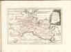
Rugiae, Usedomiae, Et Iulinae, Wandalicarum insularum Vera descriptio
Mollova mapová sbírka Ortelius, Abraham
Stettin 36, uit: Special-Karte von Mittel-Europa / nach amtlichen Quellen bearbeitet von W. Liebenow
1 : 300000 titelvariant: W. Liebenow's Mittel-Europa; Annotatie: Titel boven de bladen: W. Liebenow's Mittel-Europa Johannes Wilhelm Liebenow 1822-1897 Frankfurt a. M. : Ludwig Ravenstein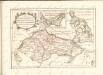
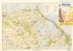
Bäderkarte Usedom

Composite: 154. Pasewalk. (Germany)
1 : 100000 Reichsamt fur Landesaufnahme
Composite: 120. Anklam. (Germany)
1 : 100000 Reichsamt fur Landesaufnahme
120. Anklam. (Germany)
1 : 100000 Reichsamt fur Landesaufnahme