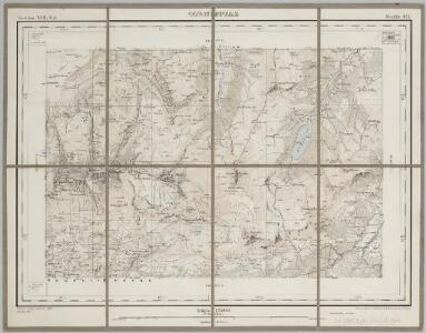
Maps of Ormont-Dessus

Tornettaz / gravée par G. Schmidt, M. Müllhaupt et H. Hügli
1 : 25000 Annotatie: Section XVII, 6d, feuille 471; Oorspr. uitg.: 1894 Georg Schmidt; Marc Müllhaupt; Hans Hügli [S.l. : Bureau topogr. fédéral]
Carte géologique du Pays d'Enhaut vaudois 1:50 000
1 : 50000 Schardt, Hans Wurster & Randegger
Carte du gouvernement d'Aigle
1 Karte : Kupferdruck ; 38 x 43 cm Rovéréa; Gruner; Clausner s.n.
Pillon / gravée par Ls. Falquet et H. Hügli
1 : 25000 Annotatie: Section XVII, 10b, feuille 478 Louis Falquet; Hans Hügli [S.l. : Bureau topogr. fédéral]
Carte du gouvernement d'Aigle
1 : 65000 Rovéréa, Isaac-Gamaliel de ; Gruner, Johann Samuel ; Clausner, Jakob Joseph [s.n.]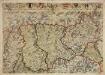
Inclitae Bernatum urbis, cum omni ditionis suae agro et provinciis delineatio chorographica, 3/4
2 Blätter : Adelbert Saueracher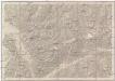
Vevey, Sion
1 : 100000
Blatt XVII: Vevey, Sion, uit: Topographische Karte der Schweiz / vermessen und hrsg. ... unter Aufsicht des Generals G.H. Dufour
1 : 100000 Annotatie: Met plaatsnamenregister (bl. V), bladwijzer (bl. XXI) en hoogteregister (bl. XXV); Voor aanwezige bladen zie overzichtsblad Dufour, G. H. [Bern : Eidg. Topogr. Bureau]
Carte des alpes fribourgeoises
1 : 100000 1 Karte E. Wagner Josué Labastrou, Fribourg
Rhodani progressus per Vallesiam
1 : 100000 1 Karte a Joanne Jacobo Scheuchzero sumptibus Petri vander Aa, Lugd. Bat. [i.e. Leiden]
Rhodani progressus per Vallesiam
1 : 100000 1 Karte juxta observationes proprias factas in Itinere Alpino a Joanne Jacobo Scheuchzero sumptibus Petri vander Aa, Lugd. Bat. [i.e. Leiden]
Topographische Karte der Schweiz
1 : 100000 25 Karten vermessen und hrsg. auf Befehl der Eidgenössischen Behörden ; aufgenommen unter der Aufsicht des Generals G.H. Dufour Eidg. Topographisches Bureau, [Genève], [später: Bern]
Sierre, Brig
1 Vogelschaukarte Orell Füssli, Zürich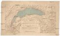
Compagnie Générale de Navigation sur le lac Léman
Labarthe, E. Compagnie générale de navigation sur le lac Léman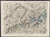
Partie du canton de Berne, du Vallais et canton de Fribourg
1 : 108000 Weiss, Johann Heinrich ; Meyer, Johann Rudolf J. R. Meyer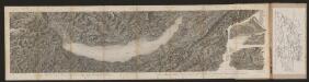
[Malerisches Relief der Schweizer- und angränzenden Alpen]
Delkeskamp, Friedrich Wilhelm F.W. Delkeskamp
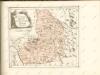
Carte du canton de Fribourg à l'usage des écoles
1 : 100000 1 Karte dressée en 1851 par Alexandre Stryienski d'après la grande carte topogr. du canton ; gravé par P. Steiner et R. Leuzinger J. Wurster et Comp., Winterthur
<<Der>> Canton Freyburg
1 : 270000 1 Karte gez. u. gest. von J.J. Scheurmann [Orell Füssli], [Zürich]
Carte chorographique de la partie occidentale de l'Oberland ou le comté de Gruyéres divisé en quatre bailliages ou gouvernements assavoir Gruyeres, Sanen, Ober Sibenthal et Nider Sibenthal, ou se trouve le gouvernement d'Aigle et le baillaige de Vevay
1 Karte : Kupferdruck ; 54 x 71 cm Loup; Benning s.n.
<<Der>> Canton Freyburg
1 : 270000 1 Karte gez. u. gest. von J.J. Scheurmann [Orell Füssli], [Zürich]

<<Der>> Canton Freyburg
1 : 270000 1 Karte gez. u. gest. von J.J. Scheurmann [Orell Füssli], [Zürich]
Carte de la partie occidentale de l'Oberland au canton de Berne
1 Karte : Kupferdruck ; 31 x 43 cm Clermont; Loup; Perrier; Beauvais; Arrivet Lamy
Carte du païs de Vallais, ou Wallisser-land
1 Karte : Kupferdruck ; 35 x 44 cm Valck; Schenk; Duval apud G. Valk et P. Schenk
Atlas Suisse
1 : 120000 16 Karten levé et dessiné par J.H. Weiss [et Joachim Eugen Müller] aux frais de J.R. Meyer à Aarau dans les années 1786 à 1802 ; gravée [sic] par [Christophe] Guérin, [Matthias Gottfried] Eichler et [Johann Jakob] Scheurmann [Johann Rudolf Meyer], Aarau
<<Der>> Canton Freyburg
1 : 270000 1 Karte gez. u. gest. von J.J. Scheurmann [Orell Füssli & Comp.], [Zürich]
Atlas novus Reipublicae Helveticae
1 Atlas ([40] Bl., 97 S.) bey Orell, Gessner und Compagnie, Zürich