Maps of British Isles

A new and correct map of Great Britain and Ireland / [John Bowles]
1 : 1000000 Annotatie: Met 15 afbeeldingen links en rechts van de kaart en 4 afbeeldingen binnen het kader van de kaart; Met opdracht aan koning George II Bowles, John [London : John Bowles]
La Grande Bretagne ou les royaumes d'Angleterre et d'Ecosse comme aussi le royaume d'Irlande
1 Karte : Kupferdruck ; 48 x 57 cm Lotter; Lotter Tobias Konrad Lotter
Regnorum Magnæ Britanniæ, sive Angliæ Scotiæ[que] nec non Hiberniæ nuperrima delineatio
1 Karte : Kupferdruck ; 49 x 58 cm Covens et Mortier
Anglia, Scotia [et] Hibernia cum insulis vicinis
1 Karte : Kupferdruck ; 26 x 33 cm Weigel s.n.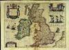
Magnæ Britanniæ et Hiberniæ tabula
1 Karte : Kupferdruck ; 37 x 51 cm Hondius ex officina et sumptibus Henrici Hondij
Regnorvm Magnae Britanniæ et Hiberniae mappa geographica
1 Karte : Kupferdruck ; 46 x 53 cm Mayer Homännische Erben
Magna Britannia complectens Angliæ, Scotiæ et Hiberniæ regna
1 Karte : Kupferdruck ; 47 x 56 cm Homann Johann Baptist Homann
Magna Britannia complectens Angliæ, Scotiæ et Hiberniæ regna
1 Karte : Kupferdruck ; 47 x 56 cm Homann Johann Baptist Homann
Magna Britannia complectens Angliae, Scotiae et Hiberniae regna
1 : 2360000 Irsko Homann, Johann Baptist Io. Bapt. Homann

Britannicæ insulæ
1 Karte : Kupferdruck ; 46 x 51 cm Sanson; Robert de Vaugondy; Santini; Remondini chez Mr. Remondini
Britannicæ insulæ
1 Karte : Kupferdruck ; 47 x 52 cm Robert de Vaugondy; Sanson; Delahaye G. et D. Robert de Vaugondy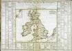
Tableau général des isles Britanniques
1 Karte : Kupferdruck ; 34 x 43 cm, Bildgrösse 52 x 73 cm Brion de la Tour; Le Campion; Le Campion chez les Campions freres m.ds d'estampes rue St. Jacques à la ville de Rouen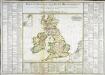
Tableau général des isles Britanniques
1 Karte : Kupferdruck ; 34 x 43 cm, Bildgrösse 52 x 73 cm Brion de la Tour; Le Campion; Le Campion chez les Campions freres m.ds d'estampes rue St. Jacques à la ville de Rouen
Magna Britannia, aut Anglia, Scotia et Hibernia
1 Karte : Kupferdruck ; 46 x 58 cm Valck; Valck G. und L. Valck

Regnorum Magnae Britanniae et Hiberniae mappa geographica
1 : 2500000 Irsko Mayer, Tobias Homan[n]ianis Heredibus
REGNORVM MAGNAE BRITANNIAE ET HIBERNIAE MAPPA GEOGRAPHICA
1 : 2500000 Flandry Mayer, Tobias edentib[us] Homan[n]ianis Heredibus
Nieuwe kaart van de eilanden van Groot Brittannien : behelzende de koningryken Engeland, Schotland en Ierland / volgens de laatste waarnemingen in het ligt gebragt ; C. Sepp del. et sculps. 1743
1 : 3500000 Annotatie: Oorspr. verschenen in: Nieuwe hand-atlas ... - Amsterdam : Isaak Tirion, 1744 Sepp, C. Te Amsterdam : by Isaak Tirion
La grande Bretagne ou les Royaumes d'Angleterre et d'Ecosse comme aussi le Royaume d'Irlande
1 : 2300000 Anglie Lotter, Matthäus Albrecht T. C. Lotter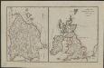
Schul-Atlas für die alte Erdbeschreibung : zur allgemeinen Schul-encyclopädie gehörig
J. H. Campe Zusammensetzung und Zeichnung von [...] Dufour, unter Leitung von Heusinger ; gestochen von Frentzel. Braunschweig : Schulbuchhandlung
La Grande Bretagne ou les royaumes d'Angleterre et d'Ecosse comme aussi le royaume d'Irlande
1 : 2300000 Anglie Lotter, Tobias Conrad Lotter, Matthäus Albrecht par Tobie Conrad Lotter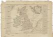
Carte des isles Britanniques
1 : 2600000 Irsko Nolin, Jean-Baptiste Daumont chez Daumont
Grossbritannien
Plastischer Schul-Atlas über alle Theile der Erde : in 24 Karten Woldermann, G Verlag von P. Eckerlein
MAGNA BRITANNIA complectens ANGLIAE, SCOTIAE ET HIBERNIAE Regn[a]
1 : 2400000 Anglie per Homannianos Heredes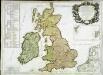
Les isles Britannicques ou sont le royaume d'Angleterre diuisé en ses quatre roy.mes des Saxons
1 Karte : Kupferdruck ; 53 x 79 cm Sanson; Robert de Vaugondy; Fortin; Gordon; Pont; Speed; Cochin chez le Sr. Fortin ing.r rue de la Harpe près celle du Foin
Nova totius Angliæ Scotiæ et Hiberniæ tab
1 Karte : Kupferdruck ; 46 x 54 cm Probst Iohann Michael Probst
Britannia prout divisa fuit temporibus Anglo-Saxonum, praesertim durante illorum Heptarchia [Karte], in: Theatrum orbis terrarum, sive, Atlas novus, Bd. 4, S. 87.
1 Karte aus Atlas Blaeu, Joan Blaeu, Willem Janszoon
58-59. Great Britain and Ireland. The World Atlas.
1 : 2500000 USSR (Union of Soviet Socialist Republics).
![A new and correct map of Great Britain and Ireland / [John Bowles]](https://images-2.georeferencer.com/images/iiif/103888303992/full/,300/0/native.jpg)

