Maps of Balkan Pen.
Ellas : Graecia, Sophiani / Abrahamo Ortelio descriptore
1 : 2500000 titelvariant: Graecia, Sophiani; Hellas; Annotatie: De kaart is uitgegeven in de periode 1597-1624; Cum priuilegio; Origineel is Blad 170 in atlas factice; Annotatie geografische gegevens: 4 schaalstokken: 1000 Stadia, en: 60 Mil. Germ., en: 70 Mil. Gall., en: 240 Mil. Ital [S.l. : Abraham Ortelius]
Nieuwe kaart des Zuiderdeels van 't Europisch Turkyen
1 : 7000000 [S.l.] : [s.n.]
Nova Graecia XXII. Nova Tabula. [Karte], in: Claud. Ptolemaeus. Geographia lat. cum mappis [...], S. 428.
1 Karte aus Atlas Münster, Sebastian [und Ptolemaeus, Claudius]
Balkan Peninsula.
1 : 3220177 Stanford, Edward
Carte de la Mer Méditerranée, 2
1 Blatt : 50 x 51 cm Froullé
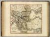
Turquie d'Europe
1 : 2650000 par le Sr. Janvier, géographe A Vénice : par François Santini [...] chez M. Redini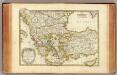
Turquie.
1 : 3900000 Janvier, Jean
Balkan-Halbinsel
1 : 4500000 Balkanhalbinsel
La Mediterranée, 2
1 Blatt : 53 x 63 cm Le Rouge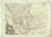
Turquie d'Europe
1 : 2500000 Turecko západní Janvier, Jean Denis Redine, M. Francois Santini
Staaten der Balkan-Halbinsel
Volksschul-Atlas über alle Teile der Erde Lange, Henry Druck und Verlag von Georg Westermann
Völkerkarte
Südosteuropa Ethnische Gruppe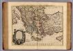
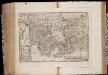
Carte de la Grece.
1 : 2500000 L'Isle, Guillaume de, 1675-1726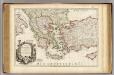
Carte de la Grece.
1 : 2500000 L'Isle, Guillaume de, 1675-1726
Serbien und der Balkan aus der Vogelschau

Ethnographische Karte des Osmanischen Reichs.
1 : 3800000 Berghaus, Heinrich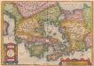
[Hellás], Graecia Sophiani. [Karte], in: Theatrum orbis terrarum, S. 404.
1 Karte aus Atlas Ortelius, Abraham
Decima Et Ultima Tabula Europae [Karte], in: Claudii Ptolemei viri Alexandrini mathematice discipline philosophi doctissimi geographie opus [...], S. 178.
1 Karte aus Atlas Waldseemüller, Martin [und Ptolemaeus, Claudius] Übelin, Georg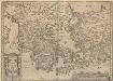
Graecia, Sophiani.[Karte], in: Theatrum orbis terrarum, S. 514.
1 Karte aus Atlas Ortelius, Abraham Vrients, Jan Baptista
Des Osmanischen Reichs europäischer Theil, Griechenland und die Jonischen Inseln
Hand-Atlas über alle Theile der Erde nach dem neuesten Zustande und über das Weltgebäude Stieler, Adolf bei Justus Perthes
Bodenschätze und Industrie
Balkanhalbinsel Wirtschaft, Mineralischer Rohstoff
Griechenland und die Länder der Balkan-Halbinsel
Plastischer Schul-Atlas über alle Theile der Erde : in 24 Karten Woldermann, G Verlag von P. Eckerlein
Turkey in Europe.
1 : 6200000 Darton, William
Des Osmanischen Reichs europäischer Theil, Griechenland und die Jonischen Inseln
Hand-Atlas über alle Theile der Erde nach dem neuesten Zustande und über das Weltgebäude Stieler, Adolf bei Justus Perthes

Turkey, Hungary
1 : 10100000 Seaman, James V.
Servia under Dušan c. 1350
Serbien Stefan Dušan, Srbija, Car
Der europäische Theil des Türkischen Reichs
1 : 1680000 Evropa jihovýchodní Reichard, C. G. Campe, Friedrich Friedrich Campe
Balkan-Halbinsel
Adolf Stieler's Handatlas über alle Theile der Erde und über das Weltgebäude Stieler, Adolf Justus Perthes