Maps of Arkhangel'sk
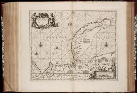
Nova Zemla : Waygats, Fretum Nassovicum, et Terra Samoiedum singula omnium emendatissimè descripta
1 : 2000000 Annotatie: Paskaart; Origineel is Blad 150 in atlas factice; Annotatie geografische gegevens: [Glijdende] schaalvermelding op kaart: 28 Milliaria Germanica, pro latitudinis gradu [66o-78o]=4,2-7,5 cm [Amstelodamum] : [Apud Ioannem Ianßonium]
Nova Zembla, Waygats, Fretum Naßovicum, et Terra Samoiedum [...] [Karte], in: Het vijfde Deel Des Grooten Atlas : Vervatende De Water-Weereld, S. 126.
1 Karte aus Atlas Jansson, Jan Jansson, Jan
Nova Zemla, Wygats, Fretum Naßovicum, et Terra Samoiedum singula omnium emendatißimè descripta. [Karte], in: Novus atlas absolutissimus, Bd. 9, S. 171.
1 Karte aus Atlas Janssonius Offizin
Carte des païs habités par les Samojedes et Ostiacs, pour l'Histoire générale des voyages
1 : 9800000 1 Karte : Kupferdruck ; 15 x 23 cm [Didot]
NOVA ZEMLA.
[Amsterdam : Joan Blaeu]
La Nouvelle Zemble
1 : 9500000 1 Karte : Kupferdruck ; 23 x 39 cm Chez Pierre van der Aa
Nördliches Eismeer Häfen in der Barentsee
Barentsovo moře Reichs-Marine-Amt
[128][131] Russiae et Novae Zemlae Maritimae, uit: Atlas sive Descriptio terrarum orbis
Annotatie: Gedigitaliseerde versie. Amsterdam. Heiloo : Picturae (vervaardiger), 2015. tiff-bestand. Gedigitaliseerd: 07-01-2015; Origineel: Universiteitsbibliotheek Vrije Universiteit (XL.05127.-) ; Netherlands; Titelpagina ontbreekt Wit, Frederik de Amsterdam : Frederick de Wit
Museumskart 182: Sjøkart over Novaja Semlja og Karahavet
1 : 50000 K. Mescherskiy | N. Zembalevskiy
Partie de la mer glaciale contenant la Nouvelle Zemble et le pays des Samoiedes / par M.Bellin Ing.
1 : 5800000 1 Karte : Kupferdruck ; 19 x 32 cm Bellin, Jacques Nicolas Didot?]
Partie de la mer glaciale contenant la Nouvelle Zemble et le pays des Samoiedes / par M.Bellin Ing.
1 : 5800000 1 Karte : Kupferdruck ; 19 x 32 cm Bellin, Jacques Nicolas [Didot?]
Feuille 5 (E I), uit: Carte géologique internationale de l'Europe : la carte, votée au congrès géologique international de Bologne en 1881, est exécutée conformément aux décisions d'une commission internationale, avec le concours des gouvernements, sous le dir. de M.M. Beyrich et Hauchecorne
Annotatie: Blad 48 gamme des couleurs; blad 49: bladwijzer en titelblad Heinrich Ernst Beyrich 1815-1896; Wi. Hauchecorne Berlin : Reimer / (Berlin: Institut lithographique)
Russiæ et Novæ Zemlæ maritimæ
1 Karte : Kupferdruck ; 48 x 56 cm Renard Louis Renard
[IV], uit: Geognostische Karte des Oesterreichischen Kaiserstaates mit einem grossen Theile Deutschland's u. Italien / hauptsachlich nach ... Haidinger's geognostischer Karte dieses Staates bearb. von Josef Scheda
1 : 3000000 titelvariant: General-Karte von Europa in 25 Blättern; Annotatie: Bijlage bij: General-Karte von Europa in 25 Blättern. - 1:2.592.000. - 1845-1847 Scheda, Joseph Wien : K.K. Militär. Geografisch. Institut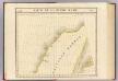
Partie, Russie d'Asie. Asie 1.
1 : 1641836 Vandermaelen, Philippe, 1795-1869
Partie, Russie d'Europe. Europe 2.
1 : 1641836 Vandermaelen, Philippe, 1795-1869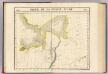
Partie, Russie d'Asie. Asie 5.
1 : 1641836 Vandermaelen, Philippe, 1795-1869
No.17. Karta Evropeyskaia Rossiia. Sheet 3
1 : 2000000 Shokalskago,Iu. M.
No.18. Karta Evropeyskaia Rossiia. Sheet 4
1 : 2000000 Shokalskago,Iu. M.
Geognostisch-geographische Übersicht des Petschora Landes
Pečora, řeka (Rusko) Keyserling, Alexander Krusenstern, Paul von
Geognostisch-geographische Übersicht des Petschora Landes
Pečora, řeka (Rusko) Keyserling, Alexander Krusenstern, Paul von
Ice Charts, White Sea (Beloye More). October - June.
U.S. Navy
Museumskart 176: Kystkart over Finnmark
1 : 100000 Theunis Jacobsz | Pieter Goos
Merkatorskaja karta rěk
Ilyč, řeka (Rusko) Krusenstern, Paul Theodor von
FRETVM NASSOVIVM | Vulgo | DE STRAET NASSOV.
[engraver: Corneel Muller] [Amsterdam : Joan Blaeu]
Ø3 Vardø
1 : 100000 Einar Sigurd Ween | Torgrim Lundtvedt
Æ2 Makkaur
1 : 100000 Finn Abrahamson | H. C. Wanggård
Æ5 Neiden
1 : 100000 Johan Gulbrandsen Natrud | C. Pedersen
Ø5 Jarfjorden
1 : 100000 Johan Nordhagen | Arnt Magnus Andreassen Øgaard