Maps of Kola Peninsula

Partie, Russie d'Europe. Europe 2.
1 : 1641836 Vandermaelen, Philippe, 1795-1869
Feuille 5 (E I), uit: Carte géologique internationale de l'Europe : la carte, votée au congrès géologique international de Bologne en 1881, est exécutée conformément aux décisions d'une commission internationale, avec le concours des gouvernements, sous le dir. de M.M. Beyrich et Hauchecorne
Annotatie: Blad 48 gamme des couleurs; blad 49: bladwijzer en titelblad Heinrich Ernst Beyrich 1815-1896; Wi. Hauchecorne Berlin : Reimer / (Berlin: Institut lithographique)
Nördliches Eismeer Häfen in der Barentsee
Barentsovo moře Reichs-Marine-Amt
[128][131] Russiae et Novae Zemlae Maritimae, uit: Atlas sive Descriptio terrarum orbis
Annotatie: Gedigitaliseerde versie. Amsterdam. Heiloo : Picturae (vervaardiger), 2015. tiff-bestand. Gedigitaliseerd: 07-01-2015; Origineel: Universiteitsbibliotheek Vrije Universiteit (XL.05127.-) ; Netherlands; Titelpagina ontbreekt Wit, Frederik de Amsterdam : Frederick de Wit
[IV], uit: Geognostische Karte des Oesterreichischen Kaiserstaates mit einem grossen Theile Deutschland's u. Italien / hauptsachlich nach ... Haidinger's geognostischer Karte dieses Staates bearb. von Josef Scheda
1 : 3000000 titelvariant: General-Karte von Europa in 25 Blättern; Annotatie: Bijlage bij: General-Karte von Europa in 25 Blättern. - 1:2.592.000. - 1845-1847 Scheda, Joseph Wien : K.K. Militär. Geografisch. Institut
Russiæ et Novæ Zemlæ maritimæ
1 Karte : Kupferdruck ; 48 x 56 cm Renard Louis Renard
[127][130] Finmarchiae et Laplandiae Maritima ..., uit: Atlas sive Descriptio terrarum orbis
Annotatie: Gedigitaliseerde versie. Amsterdam. Heiloo : Picturae (vervaardiger), 2015. tiff-bestand. Gedigitaliseerd: 07-01-2015; Origineel: Universiteitsbibliotheek Vrije Universiteit (XL.05127.-) ; Netherlands; Titelpagina ontbreekt Wit, Frederik de Amsterdam : Frederick de Wit
No.17. Karta Evropeyskaia Rossiia. Sheet 3
1 : 2000000 Shokalskago,Iu. M.
Finnmarchiae et Laplandiae Maritima
Moscovie (nord)
1 : 2600000 L'Isle, Guillaume de, 1675-1726
Mappæ imperii Moscovitici pars septentrionalis
1 Karte : Kupferdruck ; 48 x 56 cm Seutter; L'Isle Matthäus Seutter
Mappae imperii Moscovitici pars septentrionalis / adornata per Guillielmum de l'Isle membrum Academi
1 : 2600000 1 Karte : Kupferdruck ; 48 x 56 cm Seutter, Matthäus anjezo bey Johañ Michael Probst
Mappae imperii Moscovitici pars septentrionalis / adornata per Guillielmum de l'Isle membrum Academi
1 : 2600000 1 Karte : Kupferdruck ; 48 x 56 cm Seutter, Matthäus [Matthäus Seutter]
Übersichtskarte Karelien-Kola
1 : 1000000 Karélie (Rusko) Generalstab des Heeres, Abteilung für Kriegskarten und Vermessungswesen
No.16. Karta Evropeyskaia Rossiia. Sheet 2
1 : 2000000 Shokalskago,Iu. M.
Ice Charts, White Sea (Beloye More). October - June.
U.S. Navy
Museumskart 176: Kystkart over Finnmark
1 : 100000 Theunis Jacobsz | Pieter Goos
Carte de la Mer Blanche
1 : 2900000 1 Karte : Kupferdruck ; 21 x 16 cm Bellin, Jacques Nicolas [Bellin]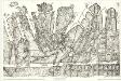
Finmarkens amt nr 7: Kart over Wardà ̧en med Omegn
1 : 20000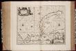
Nova Zemla : Waygats, Fretum Nassovicum, et Terra Samoiedum singula omnium emendatissimè descripta
1 : 2000000 Annotatie: Paskaart; Origineel is Blad 150 in atlas factice; Annotatie geografische gegevens: [Glijdende] schaalvermelding op kaart: 28 Milliaria Germanica, pro latitudinis gradu [66o-78o]=4,2-7,5 cm [Amstelodamum] : [Apud Ioannem Ianßonium]
Tabula Russiae
1 : 12000000 1 Karte : Kupferdruck ; 19 x 25 cm Sanson, Nicolas [Johann David Zunner]
[Ost-Europa in 6 Blättern, Blatt 2]
Handatlas über alle Theile der Erde und über das Weltgebäude Stieler, Adolf Justus Perthes
N. Russia in Europe.
1 : 9200000 Seaman, James V.
Karte von Europa, 2
4 Blätter : 52 x 70 cm Verlag der Königlich-Preussischen Academie-Kunst- und Buchhandlung
Scandinavia complectens Sveciæ, Daniæ et Norvegiæ regna
1 Karte : Kupferdruck ; 47 x 54 cm Böhme cura Homannianorum Heredum
Scandinavia complectens Sveciæ, Daniæ et Norvegiæ regna
1 Karte : Kupferdruck ; 47 x 54 cm Böhme cura Homannianorum Heredum
Scandinavia complectens Sveciæ, Daniæ et Norvegiæ regna
1 Karte : Kupferdruck ; 47 x 54 cm Böhme cura Homannianorum Heredum
Scandinavia complectens Sveciæ, Daniæ et Norvegiæ regna
1 Karte : Kupferdruck ; 47 x 54 cm Böhme cura Homannianorum Heredum
Scandinavia complectens Sveciæ, Daniæ et Norvegiæ regna
1 Karte : Kupferdruck ; 47 x 54 cm Böhme cura Homannianorum Heredum