Maps of Lower Franconia
Franconia vulgo Franckenlandt / J. Blaeu excudit
1 : 500000 Annotatie: Origineel is Blad 110 in atlas factice; Rechtsboven binnen kader: wapen van Frankenland; Annotatie geografische gegevens: Schaalvermelding op kaart: 5 Milliaria Germanica = 7,2 cm Joan Blaeu 1597/98-1673 [Amsterdam : J. Blaeu]
Franconia Vulgo Franckenlandt. [Karte], in: Theatrum orbis terrarum, sive, Atlas novus, Bd. 1, S. 251.
1 Karte aus Atlas Blaeu, Joan Blaeu, Willem Janszoon
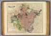
Charte vom Fränkischen Kreise
1 : 538200 Franky (Německo) Güssefeld, Franz L. im Verlage des Industrie-Comptoirs
Franconia Vulgo Franckenlandt. [Karte], in: Novus Atlas, das ist, Weltbeschreibung, Bd. 1, S. 147.
1 Karte aus Atlas Blaeu, Joan Blaeu, Willem Janszoon
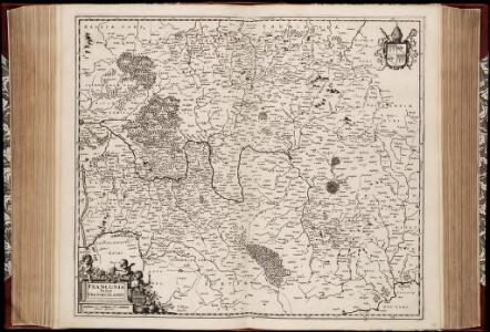
Der Fraenkische Kreis nebst den angraenzenden Laendern
1 : 350000 Franky (Německo) Hammer, C. F. Lochner, Carl Frid. im Verlag der kaiserlich privilegirten Hommanischen Handlung
Franconia Vulgo Franckenlandt. [Karte], in: Le théâtre du monde, ou, Nouvel atlas contenant les chartes et descriptions de tous les païs de la terre, Bd. 1, S. 178.
1 Karte aus Atlas Blaeu, Willem Janszoon und Blaeu, Joan Blaeu, Willem Janszoon

Charte von dem Fränkischen Kreise
1 : 569000 Franky (Německo) Kreibich, František Jakub Jindřich im Verlage des L. Ind. Compt.
Charte vom Fränkischen Kreise
1 Karte : Kupferdruck ; 44 x 53 cm Güssefeld im Verlage des Industrie-Comptoirs
Cercle de Franconie
1 Karte : Kupferdruck ; 47 x 55 cm Robert de Vaugondy; Haussard G. et D. Robert de Vaugondy
Franconia
1 : 950000 Mollova mapová sbírka Vogel
Charte von dem Fränkischen Kreise
1 Karte : Kupferdruck ; 43 x 51 cm Kreibich im Verlage des Landes-Industrie-Comptoirs
Franckenlandt. Francia orientalis. [Karte], in: Gerardi Mercatoris Atlas, sive, Cosmographicae meditationes de fabrica mundi et fabricati figura, S. 382.
1 Karte aus Atlas Mercator, Gerhard Montanus, Petrus
Der Fraenkische Kreis
1 Karte : Kupferdruck ; 44 x 54 cm Güssefeld; Schmidt bey denen Homaennischen Erben

Le Cercle de Franconie
1 : 600000 Mollova mapová sbírka Jaillot, Alexis-Hubert Ottens, Josua
Le Cercle de Franconie
1 : 600000 Mollova mapová sbírka Jaillot, Alexis-Hubert Jaillot, Alexis Hubert
Franconiae Nova Descriptio. [Karte], in: Novus atlas absolutissimus, Bd. 2, S. 174.
1 Karte aus Atlas Janssonius Offizin
Franconia vulgo Franckenlandt
1 Karte : Kupferdruck ; 37 x 48 cm Blaeu excudit Guiljelmus Blaeu
Charte von dem nordwestlichen Theile des Königreichs Bayern, dem Grossherzogthume Würzburg, dem Fürstenthume Aschaffenburg [et]c.c., oder der Maÿn
1 Karte : Kupferdruck ; 43 x 51 cm Kreibich im Verlage des Geographischen Instituts
Franckenlandt. Francia orientalis. [Karte], in: Gerardi Mercatoris et I. Hondii Newer Atlas, oder, Grosses Weltbuch, Bd. 1, S. 301.
1 Karte aus Atlas Mercator, Gerhard und Hondius, Jodocus Jansson, Jan
Nova Atque Exacta Franconiae Tabula in Ditiones Praeturas et Praefecturas.
1 : 640000 Mollova mapová sbírka Schenk, Pieter Schenk, Peter II
Franconia.
1 : 585000 Cary, John, ca. 1754-1835
Cercle de Franconie
1 Karte : Kupferdruck ; 46 x 54 cm Robert de Vaugondy; Remondini; Santini chez Mr. Remondini
Der Frænkische Kreis nebst den angraenzenden Laendern
1 Karte : Kupferdruck ; 59 x 69 cm Hammer; Lochner im Verlag der kaiserlich privilegierten Homännischen Handlung
Franconia vulgo Franckenstadt
1 : 620000 Mollova mapová sbírka Blaeu, Willem Janszoon Blaeu, Willem Jansz.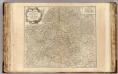
Franconie.
1 : 485000 Robert de Vaugondy, Gilles, 1688-1766
Franconiae Nova Descriptio.
1 : 620000 Mollova mapová sbírka Rittershausen, Nicolaus
Grundrichtiger Entwurff des gantzen Franckenlandes
1 : 620000 Mollova mapová sbírka Rittershausen, Nicolaus Hipschmann, Sigmund Gabriel Hoffmann, Johann