Maps of Czech Republic
Silesiae Dvcatvs accurata et vera delineatio : viris magnificis ac generosis, D. Valentino a Stößel in Seppa Kawer, D. Sigismundo a Loß in Simpsen Dammer, D. Caspari a Stosch, D. Davidi Gotfr. a Stosch {Patruelibus in Groß et Klein Tscherna, D. Gotfried ab Haugwitz in Bodelwitz, Ziebendorf / equitibus patrones dicat dedicatq. Ionas Scultetus, Sprotta Silesius
1 : 1000000 Annotatie: Rechtsboven binnen kader: XXIV; Origineel is Blad 95 in atlas factice; Annotatie geografische gegevens: Schaalstok: Milliaria Germanica Communia Jonas Scultetus 1603-1664 [S.l. : Sumptibus Janssonio-Waesbergiorum, Mosis Pitt et Stephani Swart]
Silesiae Ducatus Accurata et vera delineatio [Karte], in: Novus atlas absolutissimus, Bd. 2, S. 250.
1 Karte aus Atlas Janssonius Offizin
Silesiae Typus [Karte], in: Theatrum orbis terrarum, S. 159.
1 Karte aus Atlas Ortelius, Abraham
Silesiae Typus...

Silesiae Ducatus Nova Descriptio
Reise-Charte durch das Königreich Böhmen Hertzogthum Schlesien Marggrafthum Maehren und Lausitz
1 : 296000 Lužice (Německo) Schreiber, Johann Georg J.G. Schreibern
Silesia Ducatus [Karte], in: Novus Atlas, das ist, Weltbeschreibung, Bd. 1, S. 174.
1 Karte aus Atlas Blaeu, Joan Blaeu, Willem Janszoon
Silesia Ducatus [Karte], in: Theatrum orbis terrarum, sive, Atlas novus, Bd. 1, S. 141.
1 Karte aus Atlas Blaeu, Joan Blaeu, Willem Janszoon
Silesiae Typus [Karte], in: Theatrum orbis terrarum, S. 251.
1 Karte aus Atlas Ortelius, Abraham Vrients, Jan Baptista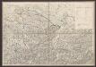
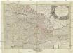
Estats De La Couronne De Boheme qui comprennent Le Royaume De Boheme Le Duché De Silesie Et Les Marquisats De Moravie et De Lusace [Karte], in: Atlas nouveau, contenant toutes les parties du monde [...], Bd. 1, S. 322.
1 Karte aus Atlas Sanson, Nicolas Jaillot, Alexis Hubert und Mortier, Pieter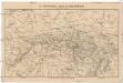
Das Kriegstheater in Schlesien, Böhmen & Sachsen
1 : 1000000 Evropa střední Baur, Carl Friedrich
Regnum Bohemiae...Ducatus Silesiae Marchionatus Moraviae et Lusatiae...

Il Regno di Boemia la Slesia Prussiana ed Austriaca noc li Marchesati di Muravia e Lusazia

Silesia Ducatus [Karte], in: Le théâtre du monde, ou, Nouvel atlas contenant les chartes et descriptions de tous les païs de la terre, Bd. 1, S. 207.
1 Karte aus Atlas Blaeu, Willem Janszoon und Blaeu, Joan Blaeu, Willem Janszoon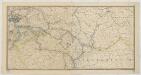
Karte der Eisenbahnen Deutschlands
1 : 700000 Südost-Blatt Stich, Druck u. Verlag des lithographischen Instituts von Aug. Wehrt
Mapa království českého
1 : 1000000
Silesiae Ducatus Nova et accurata Descriptio [Karte], in: Gerardi Mercatoris et I. Hondii Newer Atlas, oder, Grosses Weltbuch, Bd. 1, S. 343.
1 Karte aus Atlas Mercator, Gerhard und Hondius, Jodocus Jansson, Jan
Oder
Oder, Flusslauf
Böhmische Nordbahn
Evropa střední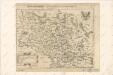
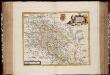
Abriss der Landschafft Schlesien, sampt den angrentzenden Königreichen und Landern

SILESIA | DVCATVS
A Martino Helwigio Nißense | descriptus. [Amsterdam : Joan Blaeu]
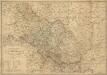
Das Herzogthum Schlesien in Nieder- und Oberschlesien dann in Fürstenthumer eingetheilt nebst der Grafschaft Glatz nach den besten und zuverlässigsten Hülfsmitteln verfasst im Jahr 1809
1 : 650000 Mollova mapová sbírka Mollo, Tranquillo Mollo, Tranquillo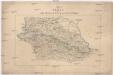
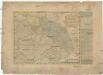
Karte vom nördlichen Kriegsschauplatze
Prusko Jacob Dirnböck
Mapa království českého
1 : 1000000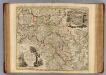
Ducatus Silesiae.
1 : 760000 Treisz, Ant.
Silesia Ducatus

Mappa geographica exactissima continens Imperatoris Hæreditarium Dominium Silesiam, nec non eiusdem Provincias interiores Ducatus, Comitatus, Baronatus etc.
1 : 700000 edente Petro Schenck [Amsterdam] : edente Petro Schenck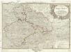
Neue und zuverlaesige General Karte von Böhmen Mähren Schlesien und Lausitz
1 : 998000 Lužice (Německo) Schütz, Carl Müller, Franz Artaria