Maps of Lower Silesian Voivodeship

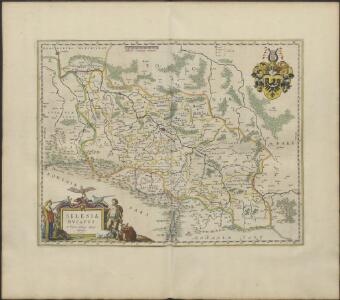
SILESIA | DVCATVS
A Martino Helwigio Nißense | descriptus. [Amsterdam : Joan Blaeu]

Silesia Ducatus [Karte], in: Le théâtre du monde, ou, Nouvel atlas contenant les chartes et descriptions de tous les païs de la terre, Bd. 1, S. 207.
1 Karte aus Atlas Blaeu, Willem Janszoon und Blaeu, Joan Blaeu, Willem Janszoon
Silesia Ducatus [Karte], in: Novus Atlas, das ist, Weltbeschreibung, Bd. 1, S. 174.
1 Karte aus Atlas Blaeu, Joan Blaeu, Willem Janszoon
Silesiae Ducatus Nova et accurata Descriptio [Karte], in: Gerardi Mercatoris et I. Hondii Newer Atlas, oder, Grosses Weltbuch, Bd. 1, S. 343.
1 Karte aus Atlas Mercator, Gerhard und Hondius, Jodocus Jansson, Jan
Silesia Ducatus [Karte], in: Theatrum orbis terrarum, sive, Atlas novus, Bd. 1, S. 141.
1 Karte aus Atlas Blaeu, Joan Blaeu, Willem Janszoon
Silesiae Typus...
Abriss der Landschafft Schlesien, sampt den angrentzenden Königreichen und Landern
Silesiae Typus [Karte], in: Theatrum orbis terrarum, S. 65.
1 Karte aus Atlas Ortelius, Abraham
Dvcatvs Silesiae
1 : 870000 Slezsko Mayer, Tobias impensis Homannianorvm Heredvm
Dvcatvs Silesiae
1 : 870000 Slezsko Mayer, Tobias impensis Homannianorvm Heredvm
Dvcatvs Silesiae
1 : 870000 Slezsko Mayer, Tobias impensis Homannianorvm Heredvm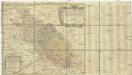
Dvcatvs Silesiae
1 : 870000 Slezsko Mayer, Tobias Homannianorvm Heredvm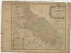
Dvcatvs Silesiae
1 : 870000 Slezsko Mayer, Tobias impensis Homannianorvm Heredvm
Dvcatvs Silesiae
1 : 870000 Slezsko Mayer, Tobias impensis Homannianorvm Heredvm
Dvcatvs Silesiae
1 : 870000 Slezsko Mayer, Tobias impensis Homannianorvm Heredvm
Dvcatvs Silesiae
1 : 870000 Slezsko Mayer, Tobias impensis Homannianorvm Heredvm
Dvcatvs Silesiae
1 : 870000 Slezsko Mayer, Tobias impensis Homannianorvm Heredvm
Silesiae Ducatus Nova Descriptio

Silesiae Typus [Karte], in: Theatrum orbis terrarum, S. 251.
1 Karte aus Atlas Ortelius, Abraham Vrients, Jan Baptista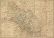
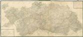
Das Herzogthum Schlesien in Nieder- und Oberschlesien dann in Fürstenthumer eingetheilt nebst der Grafschaft Glatz nach den besten und zuverlässigsten Hülfsmitteln verfasst im Jahr 1809
1 : 650000 Mollova mapová sbírka Mollo, Tranquillo Mollo, Tranquillo
Dvcatvs Silesiae Tabula geographica generalis
1 : 860000 Mollova mapová sbírka Mayer, Tobias Homann, Johann Baptista - dědici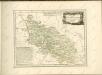
Mappa Geographica Ducatus Sylesiae

Silesia Ducatus

Sup.s et Inferioris ducatus Silesiae in suos XVII minores principatus et dominia divisi nova tabula
1 : 765000 in lucem edita a Covens et Mortier Amstelodami Amstelodami : Covens et Mortier
Mappa geographica exactissima continens Imperatoris Hæreditarium Dominium Silesiam, nec non eiusdem Provincias interiores Ducatus, Comitatus, Baronatus etc.
1 : 700000 edente Petro Schenck [Amsterdam] : edente Petro Schenck
Schlesien in nieder- und ober Schlesien, dann in Fürstenthümer eingetheilt, nebst der Grafschaft Glatz
1 : 1057000 Kladsko-oblast (Polsko) Mollo, Tranquillo T. Mollo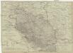
Schlesien in Nieder- und Ober Schlesien, dann in Fürstenthümer eingetheilt, nebst der Grafschaft Glatz
1 : 1057000 Kladsko-oblast (Polsko) Mollo, Tranquillo T. Mollo