Maps of Gent
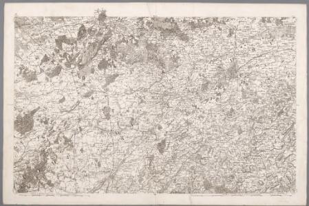
VII, uit: Carte chorographique des Pays-Bas Autrichiens / ... par le Comte de Ferraris ; gravée par L.A. Dupuis
1 : 86400 Annotatie: Lit.: Les militaires et la cartographie des Pays-Bas méridionaux et de la Principauté de Liège à la fin du XVIIe et au XVIII siècle / Claire Lemoine-Isabeau. - Bruxelles, 1984, p. 206-212; La cartographie au XVIIIe siècle et l'oeuvre du Comte de Ferraris (1726-1814) : colloque international, Spa, 8-11 sept. 1976. - Bruxelles, 1978; Met opdracht aan keizer Joseph II (bl.XVI); Met plattegrond van Brussel (bl. XXI), overzichtskaart (bl. XXII) en bladwijzer (bl. XXIII); Ontbreekt: bl. I-III en XXI; Voor aanwezige bladen zie overzichtsblad Ferraris, Johann Joseph; Dupuis, L. A. [S.l. : s.n.]
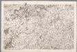
VII ; 2.J., uit: Carte chorographique des Pays-Bas Autrichiens / ... par le Comte de Ferraris ; gravée par L.A. Dupuis
1 : 86400 Annotatie: Bladen linksboven genummerd met Romeinse cijfers, rechtsboven met een cijfer en een letter; Met opdracht aan keizer Joseph II (bl.XVI); Met plattegrond van Brussel (bl. XXI), overzichtskaart (bl. XXII) en bladwijzer (bl. XXIII); Annotatie geografische gegevens: Schaalstokken: Echelle de Toises ou de Lieues communes de France; Echelle de Verges ou de Lieues de Brabant; Echelle de Milles d'Allemagne (bl. XVII); Echelle de Mètres; In de hoeken lengte- en breedtematen T.M.e en T.P.e Joseph-Jean François Ferraris Comte de 1726-1814; L.A. Dupuis [S.l. : s.n.]
Flandriae comitatus pars media, comprehendens castellaniam Yprensem, Cortracensem, Aldenardensem
1 : 130000 per Nicol. Visscher Amst. Bat. Amst. Bat. : per Nicol. Visscher
CASTELLANIÆ | CORTVRIACENSIS | TABVLA
[Amsterdam : Joan Blaeu]
Nobilibus Amplissimisq. Dominis D. Georgio de la Faille Toparchae de Neulle etc. Praetori Totiq. collegio Supremae curiae feudalis regiae Veteris burgi Gandensis
1 : 110000 Mollova mapová sbírka Blaeu, Joan Blaeu, Cornelis
Flandriae Comitatus Pars Septentrionalis
1 : 133000 Mollova mapová sbírka Visscher, Nicolaes Schenk, Peter II
Flandriae Comitatus Pars Media
1 : 133000 Mollova mapová sbírka Visscher, Nicolaes Schenk, Peter II
... Hanc Veteris Burgis novam tabulam...
[Amsterdam : Joan Blaeu]
Plan de la situation de l'Armée allié campée au bord de l'Eescaut 1744, de même que l'Armée françoise, retranchée derrière La Lis, l'année 1744
1 : 140000
Carte Particuliere des environs de Menin, Courtray, Ypre, Dixmude et Deynse
1 : 116600 Mollova mapová sbírka Fricx, Eugène Henry Harrewyn, Jacques Fricx, Eugené Henry
Carte particuliere des environs de Menin, Courtray, Ypre, Dixmunde, et Deynse
1 : 110000 Belgie Fricx, Eugene Henry chez Eugene Henry Friex
NOVA ET ACCVRATA | COMITATVS ET DITIONIS | ALOSTANÆ | in Flandria Imperiali | TABVLA
[Amsterdam : Joan Blaeu]
NOVA ET ACCVRATA | COMITATVS ET DITIONIS | ALOSTANÆ | in Flandria Imperiali | TABVLA
[Amsterdam : Joan Blaeu]
Plan du champ de bataille, prés d'Oudenaerde l'11. Juillet 1708
1 : 30000 G. Schouten f.
CASTELLANIA | ALDENARDENSIS
[Amsterdam : Joan Blaeu]
Map showing progress in Ypres area. Oct. 1917.
1 : 40000 First World War map showing progress in Ypres area. 12th October 1917. War Office
Front at Ypres. Oct. 1917. Special.
1 : 40000 First World War map of the Front at Ypres. Oct. 1917. Special. Charts British progress on the front with dates. War Office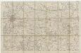
13 Bruges, uit: [Belgique 1:40.000]
1 : 40000 Annotatie: Voor aanwezige bladen zie overzichtsblad Bruxelles : Dépot de la Guerre
Carte Particuliere des environs de Menin, Courtray, Ypre, Dixmude, et Deynse
1 : 116600 Mollova mapová sbírka Fricx, Eugène Henry Covens, Johannes I
Disegno di Covtray
Kortrijk (Belgie) Bouttats, Gerhaert
Plan de la bataille d'Oudenaerde du jj juillet 1708
1 : 2400 Mosburger, G. L. Doesborgh, Thomas par Doesburgh
Plan parcellaire de la commune de Thourout : avec les mutations
1 : 5000 Royal Library of Belgium Map Room Popp, Philippe Christian (1805-1879) Popp, Philippe Christian (1805-1879)
Plan parcellaire de la commune de Nazareth : avec les mutations
1 : 5000 Royal Library of Belgium Map Room Popp, Philippe Christian (1805-1879) Popp, Philippe Christian (1805-1879)
Plan parcellaire de la commune de Aeltre : avec les mutations
1 : 5000 Royal Library of Belgium Map Room Popp, Philippe Christian (1805-1879) Popp, Philippe Christian (1805-1879)
Plan parcellaire de la commune de Evergem : avec les mutations
1 : 5000 Royal Library of Belgium Map Room Popp, Philippe Christian (1805-1879) Popp, Philippe Christian (1805-1879)
Plan parcellaire de la commune de Oedelem : avec les mutations
1 : 7500 Royal Library of Belgium Map Room Popp, Philippe Christian (1805-1879) Popp, Philippe Christian (1805-1879)
Plan parcellaire de la commune de Cruyshautem : avec les mutations
1 : 5000 Royal Library of Belgium Map Room Popp, Philippe Christian (1805-1879) Popp, Philippe Christian (1805-1879)
Hostile Artillery Dispositions. Oostnieuwkerke
1 : 20000 First World War map. Hostile Artillery Dispositions. Oct.3rd. 1917. Sheet Oostnieuwerke. War Office
Plan parcellaire de la commune de Ruysselede : avec les mutations
1 : 7500 Royal Library of Belgium Map Room Popp, Philippe Christian (1805-1879) Popp, Philippe Christian (1805-1879)