Maps of Great Rift Valley
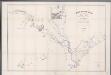
Terrenos adjacentes aos rios Zambeze e Chire : desde as suas ultimas cachoeiras até ao mar / mappa coordinado por Alfonso de Moraes Sarmento
1 : 465000 Annotatie geografische gegevens: Opname: 1877-1880 Sarmento, Alfonso de Moraes [S.l. : s.n.]
Africa orientale
1 : 14000000 Afrika východní Antonio Vallardi
Ost-Africa, Madagascar.
1 : 12900000 Radefeld, Carl Christian Franz, 1788-1874
CHARTE von einem Theile der OST-KÜSTE VON Africa
Afrika východní
Charte von einem Theile der Ost-Küste von Africa
Afrika východní
Missions catholiques du nord-est de l'Afrique comprenant l'Egypte, l'Abyssinie, le Soudan et la région du Haut-Nil
1 : 4000000 Vuillot, Paul 18..-19.. [Lyon : Oeuvre de la propagation de la foi]
Untitled

Etiópia (Abesszínia)
1 : 5000000 Annotatie geografische gegevens: Aansluitende inzetkrt: [Socotra]; Inzetkrt.: Afrika. - 1:50.000.000. Etiópia fontosabb törzsei. - [1:20.000.000] Budapest : M. Kir. Állami Térképészet
Ethiopia, Somalia, Kenya, Uganda, Rwanda, Tanzania, Burundi. Pergamon World Atlas.
Polish Army Topography Service
Die Ostküsten süd Africa nebs der Insel Madagascar, den Comoren, Sechellen, Amiranten und Mascarenischen Inseln
1 : 5000000 Komory Weiland, Karl Ferdinand Geograph. Instituts
Abessinien
1 : 5000000 Etiopie G. Freytag & Berndt
Egypte, Nubie et Abissinie
1 : 9600000 Egypt Bonne, Rigobert
[Kaart], uit: Colonie dell'Africa Orientale Italiana
1 : 4000000 Annotatie: Ondertitel op omslag: Eritrea - Somalia Italiana - Etiopia - Somalia Francese e Britannica; Annotatie geografische gegevens: Inzetkrt.: [Omgevingskaart]. - 1:50.000.000 Milano : Vallardi
Afrique Orientale.
1 : 8000000 Garnier, F. A., 1803-1863
Programma di massima della triangolazione geodetica di I° ordine dell' altopiano etiopico
1 : 3000000 Eritrea Istituto geografico militare
Die Ostküste Süd-Africa's nebst der Insel Madagascar, den Comoren, Sechellen, Amiranten und Mascarenischen Inseln
1 : 5480000 entworfen von C.F. Weiland gestochen von Mädel med. Weimar : Geographisches Institut
Abessinien
1 : 5000000 Afrika východní Josef Ulbricht
116-17. Eritrea, Etiopia, Somalia.
1 : 5000000 Touring club italiano
Arabia
1 : 11000000 Arrowsmith, Aaron Jr.
Ostafrika – Vých. Afrika

91. Arabia.
1 : 10000000 Touring club italiano
Le royaume d'Adel
1 : 9600000 Jemen Bonne, Rigobert André
States of the Arabian Peninsula. Iran, Afghanistan. Pergamon World Atlas.
Polish Army Topography Service
Arabien
1 : 5700000 entworfen und gezeichnet von C.F. Weiland Weimar : Verlag des Geograph. Instituts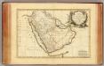
Arabie.
1 : 9300000 Bonne, Rigobert, 1727-1794
Egypt and the Nile.
1 : 5000000 John Bartholomew and Son
Egypte, Soudan, Abyssinie et Arabie. Extrait de la carte d'Afrique publiée par la librairie patriotique
1 : 6385000 Librairie patriotique (Paris) Paris : Librairie patriotique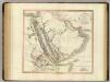
Arabia, Egypt, Abyssinia, Red Sea.
1 : 6500000 Cary, John, ca. 1754-1835


