Maps of Neckar-Odenwald-Kreis

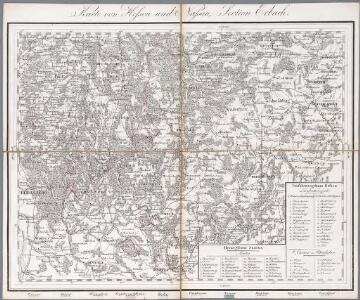
Section Erbach, uit: Charte von dem Grossherzogtum Hessen und dem Herzogtum Nassau / trigonometrisch aufgenommen und hrsg. von C.L.P. Eckhardt
1 : 200000 titelvariant: Karte von Hessen und Nassau Eckhardt, C. L. P Darmstadt : Joh. Wilh. Heyer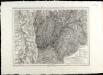
SpecialKarte von dem Odenwald, dem Bauland und einem Theil des Spessart's
1 : 216000 Haas, Johann Heinrich; Meister, G.; Felsing, Conrad
Geographica Provinciarum Sveviae Descriptio =
Mollova mapová sbírka Hurter, Johann Christoph Bodenehr, Gabriel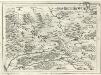
Geographica Provinciarum Sveviae Descriptio =
Mollova mapová sbírka Hurter, Johann Christoph Bodenehr, Johann Georg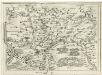
Geographica Provinciarum Sveviae Descriptio =
Mollova mapová sbírka Hurter, Johann Christoph Bodenehr, Johann Georg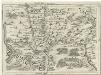
Geographica Provinciarum Sveviae Descriptio =
Mollova mapová sbírka Hurter, Johann Christoph Bodenehr, Gabriel

Landkartendarstellung
Meyer, Joseph Bibliogr. Institut
Le Flambeau de la Guerre Allumee au Rhin
Mollova mapová sbírka Delisle, Guillaume Schenk, Peter II
Heidelberg

Meßtischblatt 17 : Öhringen, 1933
1 : 250000 Öhringen. - 1:25000. - Stuttgart, 1933. - 1 Kt.
Meßtischblatt 16 : Brettach, 1933
1 : 250000 Brettach. - 1:25000. - Stuttgart, 1933. - 1 Kt.
Meßtischblatt 15 : Kochendorf, 1902
1 : 250000 Kochendorf. - 1:25000. - Stuttgart, 1902. - 1 Kt.
Meßtischblatt 14 [6720]: Gundelsheim, 1902
1 : 250000 Gundelsheim. - 1:25000. - Stuttgart, 1902. - 1 Kt.
Meßtischblatt 42 : Sinsheim, 1877
1 : 250000 Sinsheim. - 1:25000. - Leipzig: Giesecke & Devrient, 1877. - 1 Kt.
Meßtischblatt 41 : Wiesloch, 1877
1 : 250000 Wiesloch. - 1:25000. - Leipzig: Giesecke & Devrient, 1877. - 1 Kt..
Meßtischblatt 37 + 38 [6623]: Krautheim, 1882
1 : 250000 Krautheim. - Ausg.] 1881 u. 1882. - 1:25000. - Leipzig : Giesecke & Devrient, 1882. - 1 Kt.
Meßtischblatt 36 [6622]: Sennfeld, 1881
1 : 250000 Sennfeld. - [Ausg.] 1880 u. 81. - 1:25000. - Leipzig : Giesecke & Devrient, 1881. - 1 Kt.
Meßtischblatt 7/8 [preuss. 6621]: Böttingerhof u. Siglingen, 1904
1 : 250000 7/8 : Böttingerhof u. Siglingen. - 1:25000. - Stuttgart , 1904. - 1 Kt.
Meßtischblatt 34 : Mosbach, 1907
1 : 250000 Mosbach. - 2. Aufl., Nachtr. bis incl. 1907. - 1:25000. - 1907. - 1 Kt.
Meßtischblatt 33 : Epfenbach, 1936
1 : 250000 Epfenbach. - [Hrsg.] 1880, bericht. 1936. - 1:25000. - [Karlsruhe]: Bad. Fin.- u. Wirtsch.-Min., Abtlg., 1936. - 1 Kt.
Meßtischblatt 32 : Neckargemünd, 1878
1 : 250000 Neckargemünd. - 1:25000. - Leipzig: Giesecke & Devrient, 1878. - 1 Kt.
Meßtischblatt 28 : Boxberg, 1886
1 : 250000 Boxberg. - 1:25000. - Leipzig: Giesecke & Devrient, 1886. - 1 Kt.
Meßtischblatt 27 : Adelsheim, 1880
1 : 250000 Adelsheim. - 1:25000. - Leipzig: Giesecke & Devrient, 1880. - 1 Kt.
Meßtischblatt Oberschefflenz
1 : 250000 Oberschefflenz. - 1:25000. - 1929. - 1 Kt.
Meßtischblatt 25 : Zwingenberg, 1923
1 : 250000 Zwingenberg. - Revidiert 1923. - 1:25000. - [Karlsruhe]: Bad. Wasser- und Straßenbaudirektio, 1923. - 1 Kt.
Meßtischblatt 24 : Eberbach, 1880
1 : 250000 Eberbach. - 1:25000. - Leipzig: Giesecke & Devrient, 1880. - 1 Kt.
Meßtischblatt 23 : Heidelberg, 1878
1 : 250000 Heidelberg. - 1:25000. - Leipzig: Giesecke & Devrient, 1878. - 1 Kt.
Meßtischblatt 19 : Gissigheim, 1886
1 : 250000 Gissigheim. - [Ausg.] 1881 u. 1886. - 1:25000. - Leipzig: Giesecke & Devrient, 1886. - 1 Kt.