Maps of Rhein-Neckar-Kreis
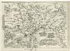
Geographica Provinciarum Sveviae Descriptio =
Mollova mapová sbírka Hurter, Johann Christoph Bodenehr, Johann Georg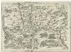
Geographica Provinciarum Sveviae Descriptio =
Mollova mapová sbírka Hurter, Johann Christoph Bodenehr, Gabriel
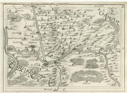
Le Flambeau de la Guerre Allumee au Rhin
Mollova mapová sbírka Delisle, Guillaume Schenk, Peter II
Landkartendarstellung
Meyer, Joseph Bibliogr. Institut
Mannheim

Heidelberg

Meßtischblatt 34 : Mosbach, 1907
1 : 250000 Mosbach. - 2. Aufl., Nachtr. bis incl. 1907. - 1:25000. - 1907. - 1 Kt.
Meßtischblatt 33 : Epfenbach, 1936
1 : 250000 Epfenbach. - [Hrsg.] 1880, bericht. 1936. - 1:25000. - [Karlsruhe]: Bad. Fin.- u. Wirtsch.-Min., Abtlg., 1936. - 1 Kt.
Meßtischblatt 32 : Neckargemünd, 1878
1 : 250000 Neckargemünd. - 1:25000. - Leipzig: Giesecke & Devrient, 1878. - 1 Kt.
Meßtischblatt 6616 : Speyer, 1924
1 : 250000 Speyer. - [Stand ca. 1924]. - 1:25000. - Wiesbaden: Hauptvermessungsabteilung XI, 1924. - 1 Kt.
Meßtischblatt 25 : Zwingenberg, 1923
1 : 250000 Zwingenberg. - Revidiert 1923. - 1:25000. - [Karlsruhe]: Bad. Wasser- und Straßenbaudirektio, 1923. - 1 Kt.
Meßtischblatt 24 : Eberbach, 1880
1 : 250000 Eberbach. - 1:25000. - Leipzig: Giesecke & Devrient, 1880. - 1 Kt.
Meßtischblatt 23 : Heidelberg, 1878
1 : 250000 Heidelberg. - 1:25000. - Leipzig: Giesecke & Devrient, 1878. - 1 Kt.
Meßtischblatt [6517] : Ladenburg, 1910
1 : 250000 Ladenburg. - 2. Aufl., erg. 1904, einz. Nachtr. 1910. - 1:25000. - Leipzig: Giesecke & Devrient, 1910. - 1 Kt.
Meßtischblatt 22 : Ladenburg, 1881
1 : 250000 Ladenburg. - 1:25000. - Leipzig: Giesecke & Devrient, 1881. - 1 Kt.
Meßtischblatt 16 : Schlossau, 1880
1 : 250000 Schlossau. - 1:25000. - Leipzig: Giesecke & Devrient, 1880. - 1 Kt.
Meßtischblatt 3519, neue Nr. 6418 : Birkenau, 1937
1 : 250000 Birkenau. - Bearb. 1899-1901, kl. Nachtr. bis 1926, bericht. 1937. - 1:25000. - Damstadt: Hess. Landesvermessungsamt, 1937. - 1 Kt.
Meßtischblatt 14 : Weinheim, 1881
1 : 250000 Weinheim. - 1:25000. - Leipzig: Giesecke & Devrient, 1881. - 1 Kt.
Meßtischblatt 13 : Käferthal, 1885
1 : 250000 Käferthal. - [Ausg.] 1881 u. 1885. - 1:25000. - Leipzig: Giesecke & Devrient, 1885. - 1 Kt.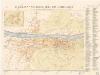
Beckmann ́s Neuester Plan von Heidelberg

Manheimium
Mollova mapová sbírka Seutter, Matthäus Seutter, Matthäus
Manheimium
Mannheim (Německo) Seutter, Matthäus Adrichem, Christiaan van per Matthaeum Seutter
Manheimium
Mannheim (Německo) Seutter, Matthäus Furlanetto, Lodovico per Matthaeum Seutter
Plan der Stadt Heidelberg & Umgegend
1 : 10000 Heidelberg Petters
Mannheim

Lage-Plan der Kreisstadt Heppenheim mit Umgebung
1 : 2500 Welzbacher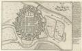
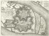
Plan von Manheim :
1 : 13000 Mollova mapová sbírka Bodenehr, Gabriel Bodenehr, Gabriel
Grundriss des innern Raums der Churf. Pfalz. Resid. Stadt Mannheim
Mannheim (Německo) Dewarat, Peter
Hodierna Sedes Electoris Palatini Manheimium
1 : 8000 Mollova mapová sbírka Homann, Johann Baptist Homann, Johann Baptista - dědici