Maps of Baincthun

No. 22 [Boulogne], uit: Carte géométrique de la France dite "Carte de Cassini" ou "de l'Académie"
1 : 86400 titelvariant: Carte de Cassini; Annotatie: Incompleet; Voor aanwezige bladen zie overzichtsblad Cassini de Thury, C.-F. Paris : [s.n.]
22 Boulogne.
1 : 86400 Cassini family; Cassini, Cesar-Francois, 1714-1784
[Boulogne]
1 Blatt : 60 x 47 cm Le Roy s.n.
France and Belgium 1:50,000, Boulogne
This topographic sheet, France and Belgium 1:50 000, Series GSGS 4040 [Defences], contains standard topographic informaation including contours. Great Britain. Army. Royal Engineers. Map Reproduction Section, 18th. [S.l.] : [s.n.]
Les Costes du Boulenois et de la Picardie
1 : 116600 Mollova mapová sbírka Fricx, Eugène Henry Harrewyn, Jacques Fricx, Eugené Henry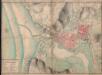
A colored "plan du port de la ville haute et basse de Boulogne
A colored manuscript plan du port de la ville haute et basse de Boulogne, France; fait et mésuré par le Sr. Marie, ingénieur du roy, en 1716 et 1717; "drawn on a scale of 62 1/2 toises to an inch."
Le Canal et Partie dela France
1 : 116600 Mollova mapová sbírka Fricx, Eugène Henry Covens, Johannes I
Comitatuum Boloniae et Guines Descriptio. [Karte], in: Novus Atlas, das ist, Weltbeschreibung, Bd. 2, S. 23.
1 Karte aus Atlas Blaeu, Joan Blaeu, Willem Janszoon
Comitatuum Boloniae et Guines Descriptio. [Karte], in: Theatrum orbis terrarum, sive, Atlas novus, Bd. 2, S. 38.
1 Karte aus Atlas Blaeu, Joan Blaeu, Willem Janszoon
Comitatuum Boloniae et Guines Descriptio. [Karte], in: Le théâtre du monde, ou, Nouvel atlas contenant les chartes et descriptions de tous les païs de la terre, Bd. 2, S. 23.
1 Karte aus Atlas Blaeu, Willem Janszoon und Blaeu, Joan Blaeu, Willem Janszoon
COMITATVVM | BOLONIÆ | et GVINES | DESCRIPTIO.
Guilielmus Blaeu excud. Amsterdami.
Caletensium Et Bononiensium Ditionis Accurata Delineatio. [Karte], in: Theatrum orbis terrarum, S. 136.
1 Karte aus Atlas Ortelius, Abraham Vrients, Jan Baptista
Caletensium Et Bononiensium Ditionis Accurata Delineatio. [Karte], in: Theatrum orbis terrarum, S. 79.
1 Karte aus Atlas Ortelius, Abraham
Caletenisum Et Bononiensium Ditionis Accurata Delineatio. [Karte], in: Theatrum orbis terrarum, S. 34.
1 Karte aus Atlas Ortelius, Abraham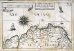
Capitainerie garde-coste d'Estaples et partie de celle de Sangatte et du Crotoy
1 Karte : 22 x 33 cm de Fer

Sheet 9. (Cary's England, Wales, and Scotland).
1 : 360000 Cary, John, ca. 1754-1835
Oromansaci, et Gesoriacus pagus in Morinis
1 Karte : Kupferdruck ; 41 x 54 cm Sanson; Robert de Vaugondy; Cordier ches le Sr. Robert g. du r. quai de l'Horloge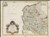
Oromansaci, et Gesoriacus Pagus in Morinis, evesché de Boulogne ou sont les Comté et seneschaussée de Boulenois : Balliage de Calais dans le Pays Reconquis : Souveraineté d'Ardres, etc.
1 : 211000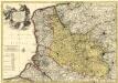
Le Comté d'Artois, et des Environs, ou l'on voit le Ressort du Conseil Provincial d'Artois avec les Frontieres de Picardie
1 : 250000 Mollova mapová sbírka Visscher, Nicolaes Schenk, Pieter Visscher, Nicolaus I.
A new travelling map of the country round London, 4
1 Blatt : 49 x 60 cm J. Andrews & A. Drury
Het Nauw van Calais en omgeving (Le Tréport-Oostende)
1 : 750000 Annotatie: Vrijgegeven door W.B.N. (WehrmachtBereich Niederlande?) 26-5 '44; Rechtsonder: K 1148 Den Haag : Kompas
Carte de la Picardie, Artois, Boulonois, Flandre françoise, Haynaut et Cambresis, 1
2 Blätter : 62 x 43 cm Bourgoin
3) II.O. ''Boulogne'', uit: Carte géologique de France
1 : 500000 Annotatie: Voor aanwezige bladen zie bladoverzicht [S.l : s.n.]
Artois
1 Karte : Kupferdruck ; 37 x 48 cm Surhon; Ortelius; Surhon s.n.
Carte Contenant le Pais entre Boulogne, Aire, Amiens, et Dieppe
1 : 200000 Mollova mapová sbírka Le Rouge, Georges-Louis Le Rouge, Georges-Louis
Artesia, Comitatus. Artois. [Karte], in: Le théâtre du monde, ou, Nouvel atlas contenant les chartes et descriptions de tous les païs de la terre, Bd. 1, S. 380.
1 Karte aus Atlas Blaeu, Willem Janszoon und Blaeu, Joan Blaeu, Willem Janszoon

Artesia, Comitatus Artois. [Karte], in: Novus atlas absolutissimus, Bd. 3, S. 138.
1 Karte aus Atlas Janssonius Offizin
![No. 22 [Boulogne], uit: Carte géométrique de la France dite](https://images-2.georeferencer.com/images/iiif/606629447049/full/,300/0/native.jpg)

