Maps of Abbeville

Sheet 9. (Cary's England, Wales, and Scotland).
1 : 360000 Cary, John, ca. 1754-1835
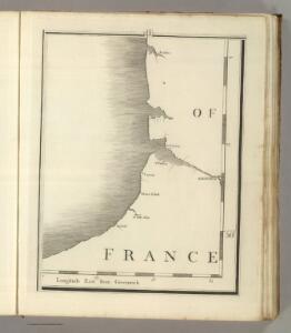
[Dieppe]
1 Blatt : 60 x 91 cm s.n.
23 Dieppe.
1 : 86400 Cassini family; Cassini, Cesar-Francois, 1714-1784
Ponthiev comitatvs
1 Karte : Kupferdruck ; 14 x 19 cm Lambert Andreae
Les Embouchures de la Somme et de Bresle Riv. ou est St. Valeri, Eu et Dieppe
1 : 116600 Mollova mapová sbírka Fricx, Eugène Henry Covens, Johannes I
France 1:50,000 , Series GSGS 4250, Eu
France 1:50,000 , Series GSGS 4250. Great Britain. War Office. General Staff. Geographical Section. [London] : Ordnance Survey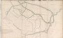
An outline plan of Abbeville
An outline plan of the town of Abbeville in France; drawn about 1630, on a scale of 37 toises to an inch.
Le Canal et Partie dela France
1 : 116600 Mollova mapová sbírka Fricx, Eugène Henry Covens, Johannes I
Les Costes du Boulenois et de la Picardie
1 : 116600 Mollova mapová sbírka Fricx, Eugène Henry Harrewyn, Jacques Fricx, Eugené Henry
Carte Contenant le Pais entre Boulogne, Aire, Amiens, et Dieppe
1 : 200000 Mollova mapová sbírka Le Rouge, Georges-Louis Le Rouge, Georges-Louis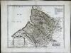
Britanni
1 Karte : Kupferdruck ; 38 x 50 cm Sanson; Robert de Vaugondy; Cordier ches le S. Robert geogr. ord. du r. quai de l'Horloge du Palais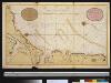
Een gedeelte van het Kanaal van Boulogne tot aen Sotteville int groodt
France Gerard van Keulen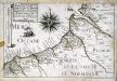
Les capitaineries garde-costes de St. Valery, Cayeu, Treport, Cryelle, Val de Conte, Dieppe, de la Chapelle S.te Marguerite, de la vallée de Senne, et celle du Crotoy
1 Karte : 22 x 33 cm de Fer
Les embouchures de la Somme et de Bresle Riv., où est St. Valeri, Eu et Dieppe
1 : 120000 J. Harrewyn f[ecit] Bruxelles : chez Eugene Henry Fricx
Les Embouchures de la Somme et de Bresle Riv: où est S. Valeri, Eu et Dieppe
1 : 116600 Mollova mapová sbírka Fricx, Eugène Henry Harrewyn, Jacques Fricx, Eugené Henry
Les costes du Boulenois et de la Picardie
1 : 110000 Boulogne-sur-Mer (Francie) Fricx, Eugene Henry Harrewyn, Jacques chez Eugene Henry Fricx
Les embouchures de la Somme et de Bresle riv. ou est St. Valeri, Eu et Dieppe
1 : 110000 Dieppe (Francie) Fricx, Eugene Henry Harrewyn, Jacques chez Eugene Henry Fricx
22 Boulogne.
1 : 86400 Cassini family; Cassini, Cesar-Francois, 1714-1784
No. 22 [Boulogne], uit: Carte géométrique de la France dite "Carte de Cassini" ou "de l'Académie"
1 : 86400 titelvariant: Carte de Cassini; Annotatie: Incompleet; Voor aanwezige bladen zie overzichtsblad Cassini de Thury, C.-F. Paris : [s.n.]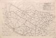
Third Army Traffic Map: June 1918
1 : 100000 First World War Third Army Traffic Map. June 1918. Overprinted on sheet 'Third Army administrative map'. Shows direction traffic must take, speed of vehicles, where not to take horses and mules. War Office
[Boulogne]
1 Blatt : 60 x 47 cm Le Roy s.n.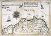
Capitainerie garde-coste d'Estaples et partie de celle de Sangatte et du Crotoy
1 Karte : 22 x 33 cm de Fer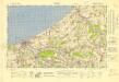
France 1:50,000 , Series GSGS 4250, Dieppe
France 1:50,000 , Series GSGS 4250. Great Britain. War Office. General Staff. Geographical Section. [London] : Ordnance Survey
Carte Particuliere des Environs d'Arthois du Boulenois et d'une Partie de la Picardie
1 : 250000 Mollova mapová sbírka Seutter, Matthäus Lotter, Tobias Conrad Seutter, Matthäus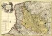
Le Comté d'Artois, et des Environs, ou l'on voit le Ressort du Conseil Provincial d'Artois avec les Frontieres de Picardie
1 : 250000 Mollova mapová sbírka Visscher, Nicolaes Schenk, Pieter Visscher, Nicolaus I.
Carte de la Picardie, Artois, Boulonois, Flandre françoise, Haynaut et Cambresis, 1
2 Blätter : 62 x 43 cm Bourgoin
Carte generale de Picardie
1 Karte : Kupferdruck ; 25 x 35 cm Merian Caspar Merian
delineation of the strata of England and Wales, with part of Scotland
1 : 320000 Blatt 14 Smith, William Cary

Carte du GOVVERNEMENT GENERAL DE PICARDIE
1 : 380000 Amiens-oblast (Francie) Delisle, Guillaume par les Heritiers de Homan