Maps of Eifelkreis Bitburg-Prüm

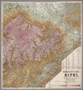
Höhenschichten-Karte der Eifel / von H. Rauff ; gezeichn. von W. Rose
1 : 200000 Annotatie geografische gegevens: Gebaseerd op: Topografische Uebersichtskarte des Deutschen Reiches Hermann Rauff; W. Rose fl. 1900 Bonn : Cohen
Archiepiscopatus et Electoratus Trevirensis Novissima delineatio
1 : 310000 Mollova mapová sbírka Wit, Frederik de Wit, Frederick
Sheet 1, uit: Stanford's large scale map of the seat of war / Stanford's Geographical Estab[lishmen]t
1 : 300000 Stanford's Geographical Establishment, Londen London : Stanford
Prüm 98, uit: [W. Liebenow's Special-Karte von Mittel-Europa]
1 : 300000 titelvariant: W. Liebenow's Mittel-Europa; Annotatie: Titel boven de bladen: W. Liebenow's Mittel-Europa Johannes Wilhelm Liebenow 1822-1897 Hannover : Hermann Oppermann
Prüm 98, uit: Special-Karte von Mittel-Europa / nach amtlichen Quellen bearbeitet von W. Liebenow
1 : 300000 titelvariant: W. Liebenow's Mittel-Europa; Annotatie: Titel boven de bladen: W. Liebenow's Mittel-Europa Johannes Wilhelm Liebenow 1822-1897 Frankfurt a. M. : Ludwig Ravenstein

Archiepiscopatus ac Electoratus Trevirensis ditio
1 : 310000 Mollova mapová sbírka Visscher, Nicolaes Gouwen, Giliam van der Schenk, Peter II
Trevirensis Archi-Episcopatus et Electoratus
1 : 310000 Mollova mapová sbírka Seutter, Matthäus Seutter, Matthäus
Mosellae Fluminis Tabula Specialis
1 : 310000 Mollova mapová sbírka Homann, Johann Baptist Homann, Johann Baptista - dědici

Archiepiscopatvs Trevirensis
1 : 370000 Mollova mapová sbírka Blaeu, Willem Janszoon Blaeu, Cornelis
Archiepiscopatvs Trevirensis
1 : 370000 Mollova mapová sbírka Janssonius, Johannes Janssonius, Johannes I
Treveri Archidiacne. de Coblents dans le Dioecese de l'Archevche de Treves.
Mollova mapová sbírka Sanson, Guillaume Sanson, Guillaume
Carte topographique tres exacté de la Wetteravie
1 : 220000 Hesensko (Německo) Coentgen, Heinrich Hugo chez I.W.A. Iaeger
Carte topographique tres exacté de la Wetteravie
1 : 220000 Hesensko (Německo) Jaeger, Johann Wilhelm Abraham I. W. A. Jaeger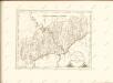

Theatre De La Guerre Dans Les Pays Qui Sont Situéz Entre le Rhin, la Saare, la Moselle et la Basse Alsace. [Karte], in: Atlas nouveau, contenant toutes les parties du monde [...], Bd. 1, S. 235.
1 Karte aus Atlas Sanson, Nicolas Jaillot, Alexis Hubert und Mortier, Pieter
Partie Occidentale Du Temporel De L'Archevesché et Eslectorat, De Treves. [Karte], in: Atlas nouveau, contenant toutes les parties du monde [...], Bd. 1, S. 196.
1 Karte aus Atlas Sanson, Nicolas Jaillot, Alexis Hubert und Mortier, Pieter
XV, uit: Carte chorographique des Pays-Bas Autrichiens / ... par le Comte de Ferraris ; gravée par L.A. Dupuis
1 : 86400 Annotatie: Lit.: Les militaires et la cartographie des Pays-Bas méridionaux et de la Principauté de Liège à la fin du XVIIe et au XVIII siècle / Claire Lemoine-Isabeau. - Bruxelles, 1984, p. 206-212; La cartographie au XVIIIe siècle et l'oeuvre du Comte de Ferraris (1726-1814) : colloque international, Spa, 8-11 sept. 1976. - Bruxelles, 1978; Met opdracht aan keizer Joseph II (bl.XVI); Met plattegrond van Brussel (bl. XXI), overzichtskaart (bl. XXII) en bladwijzer (bl. XXIII); Ontbreekt: bl. I-III en XXI; Voor aanwezige bladen zie overzichtsblad Ferraris, Johann Joseph; Dupuis, L. A. [S.l. : s.n.]
Le Duché de Luxembourg divisé en Quartier Walon et Allemand
1 : 140000 Mollova mapová sbírka Jaillot, Alexis-Hubert Jaillot, Alexis Hubert
Mosellauf von Koblenz bis Trier : mit seitlich angebrachtem Führer
Annotatie: Op omslag: Nr. 28 Da; Met beschrijving van bezienswaardigheden aan weerszijden van de kaart Köln : Bremer
Carte Nouvelle de la Haute Partie de l'Archevesché et Eslectorat de Cologne Avec ses Enclaves dans les Pays Circomvoisins.
1 : 170000 Mollova mapová sbírka Sanson, Guillaume Ottens, Josua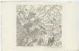
XV ; 3.M., uit: Carte chorographique des Pays-Bas Autrichiens / ... par le Comte de Ferraris ; gravée par L.A. Dupuis
1 : 86400 Annotatie: Bladen linksboven genummerd met Romeinse cijfers, rechtsboven met een cijfer en een letter; Met opdracht aan keizer Joseph II (bl.XVI); Met plattegrond van Brussel (bl. XXI), overzichtskaart (bl. XXII) en bladwijzer (bl. XXIII); Annotatie geografische gegevens: Schaalstokken: Echelle de Toises ou de Lieues communes de France; Echelle de Verges ou de Lieues de Brabant; Echelle de Milles d'Allemagne (bl. XVII); Echelle de Mètres; In de hoeken lengte- en breedtematen T.M.e en T.P.e Joseph-Jean François Ferraris Comte de 1726-1814; L.A. Dupuis [S.l. : s.n.]
137. Cochem, uit: Topographische Uebersichtskarte des Deutschen Reiches / herausgegeben v. d. Kartogr. Abt. d. Königl. Preuß. Landesaufnahme
1 : 200000 titelvariant: Topogr. Übersichtskarte des Deutschen Reiches; Annotatie: Titel boven bladen ook: Topogr. Übersichtskarte des Deutschen Reiches; Annotatie geografische gegevens: Op elk blad twee maatstokken: 10 Kilometer = 5,5 cm; 1 geogr. Meile = 3,6 cm; Legenda onder op elk blad Königlich Preußische Landesaufnahme. Kartographische Abtheilung [S.l : Königlich Preußische Landesaufnahme, Kartographische Abtheilung]
Theatre de la Guerre sus la Mosella, avec le choc., qui se donna entre les deux Armées le 20. Octobre 1735
Mollova mapová sbírka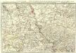
Exactissima totius Vederoviae laté sumtae Tabula
1 : 210000 Mollova mapová sbírka Buna, Wilhelm C. Broenner, Heinrich Ludwig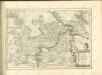

Archiepiscopatus Coloniensis Pars Australis
1 : 260000 Mollova mapová sbírka Gigas, Johann Michael
Archiepiscopatus Coloniensis Pars Australis
1 : 260000 Mollova mapová sbírka Gigas, Johann Michael