Maps of Vevey
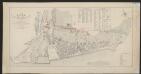
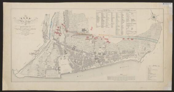
Plan de la ville de Vevey
1 : 2000 Rossier, Vincent ; Wagner, J.F. [s.n.]
Carte topographique du canton de Fribourg
1 : 50000 Südwest-Blatt Stryienski, Alexandre ; Delsol, Théodore ; Hacq, J.M. ; Carré, ... F. Chardon ainé
Topographische Karte des Kantons Freiburg: Blatt 2
1 : 50000 Stryienski, Casimir Napoléon Alexandre (1804-1875), Ingenieur, von Polen Kupferstich: Delsol, Théodore (1819-1870), von Frankreich; Hacq, J. M.; Carré. V.
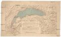
Vero dissegno del lago di Geneva con i lvoghi chel circondano
1 : 200000 Bertelli, Luca Franco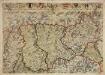
Inclitae Bernatum urbis, cum omni ditionis suae agro et provinciis delineatio chorographica, 3/4
2 Blätter : Adelbert Saueracher
Carte de la Suisse romande, 4
1 Blatt : s.n.
Carte de la Suisse romande, 4
1 Blatt : s.n.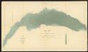
Lac Léman
1 : 50000 Hörnlimann, J. ; Lochmann, Jean Jacques ; Magnin, J. Ministère des Travaux Publics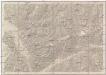
Vevey, Sion
1 : 100000
Blatt XVII: Vevey, Sion, uit: Topographische Karte der Schweiz / vermessen und hrsg. ... unter Aufsicht des Generals G.H. Dufour
1 : 100000 Annotatie: Met plaatsnamenregister (bl. V), bladwijzer (bl. XXI) en hoogteregister (bl. XXV); Voor aanwezige bladen zie overzichtsblad Dufour, G. H. [Bern : Eidg. Topogr. Bureau]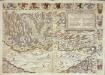
Inclitae Bernatum urbis, cum omni ditionis suae agro et provinciis delineatio chorographica, 5/6
2 Blätter : Adelbert Saueracher
Carte archéologique du Canton de Fribourg
1 : 100000 Bonstetten, Gustav Karl <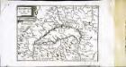
Description du lac de Geneue
1 Karte : Kupferdruck ; 11 x 15 cm Sebastian Cramoisy
Carte des alpes fribourgeoises
1 : 100000 1 Karte E. Wagner Josué Labastrou, Fribourg
Der Canton Freyburg
1 : 228000 Fribourg (Švýcarsko : kanton) Scheurmann, J. J.
[Nozeroy - les Rousses]
1 Blatt : 59 x 90 cm s.n.
Atlas der Schweiz
1 : 450000 1 Atlas (18 Bl.) gez. u. gest. v. J. Scheurmann Orell Fussli, Zurich
Canton Freyburg
1 : 270000 Scheuermann, Johann Jakob [Orell Füssli]
Carte du canton de Fribourg à l'usage des écoles
1 : 100000 Stryienski, Alexandre J. Wurster et Comp.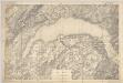
Lac Léman : carte au 1:100.000e : report sur pierre d'une partie des feuilles XI, XII, XVI, XVII de la Carte Dufour
1 : 100000 [S.l. : Bureau topographique fédéral]
Carte du canton de Fribourg
1 : 200000 1 Karte J.S. Gerster Wurster, Randegger & Cie., Winterthur
Topographische Karte der Schweiz
1 : 100000 25 Karten vermessen und hrsg. auf Befehl der Eidgenössischen Behörden ; aufgenommen unter der Aufsicht des Generals G.H. Dufour Eidg. Topographisches Bureau, [Genève], [später: Bern]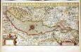
Chorographica tabula lacus Lemanni locorumqve circumiacentium
1 Karte : Kupferdruck ; 29 x 54 cm Mercator; Hondius; Goulart Henricus Hondius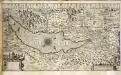
Chorographica tabula lacus Lemanni locorumqve circumiacentium
1 Karte : Kupferdruck ; 29 x 54 cm Mercator; Hondius; Goulart Jodocus Hondius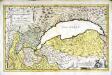
Dvcatvs Chablasivs et lacvs Lemanvs
1 Karte : Kupferdruck ; 36 x 58 cm Blaeu; Borgonio; Broen; Ottens; Ottens invenitur apud R. et I. Ottens geographos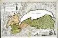
Dvcatvs Chablasivs et lacvs Lemanvs
1 Karte : Kupferdruck ; 36 x 58 cm Blaeu; Borgonio; Broen Joannes Blaeu excudit
Plus grande partie de la Suisse romande ou canton du Léman
1 : 108000 Weiss, Johann Heinrich ; Guérin, Christophe ; Meyer, Johann Rudolf J. R. Meyer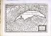
Lac Leman
1 Karte : Kupferdruck ; 13 x 19 cm s.n.
Canton Freiburg sive pagus Helvetiæ Friburgensis cum confinibus
1 Karte : Kupferdruck ; 22 x 26 cm Walser Homännische Erben