Maps of Gruyère District

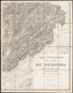
Carte topographique du canton de Fribourg
1 : 50000 Südost-Blatt Stryienski, Alexandre ; Delsol, Théodore ; Hacq, J.M. ; Carré, ... F. Chardon ainé
Topographische Karte des Kantons Freiburg: Blatt 1
1 : 50000 Stryienski, Casimir Napoléon Alexandre (1804-1875), Ingenieur, von Polen Kupferstich: Delsol, Théodore (1819-1870), von Frankreich; Hacq, J. M.; Carré. V.
Partie de la chaîne du Mt. Stockhorn entre le Simmenthal et les frontières du Canton de Frybourg
Studer, Bernhard Berthe, Rue St. Jacques
Karte der westlichen Stockhornkette
1 : 50000 1 Karte bearbeitet von R. Leuzinger ; [Lith.:] Topogr. Anstalt v. Wurster, Randegger & Co. in Winterthur [Verlag der Expedition des Jahrbuches des S.A.C.], [Bern]
Carte géologique du Pays d'Enhaut vaudois 1:50 000
1 : 50000 Schardt, Hans Wurster & Randegger
Carte archéologique du Canton de Fribourg
1 : 100000 Bonstetten, Gustav Karl <
Carte des alpes fribourgeoises
1 : 100000 1 Karte E. Wagner Josué Labastrou, Fribourg
Der Canton Freyburg
1 : 228000 Fribourg (Švýcarsko : kanton) Scheurmann, J. J.
Atlas der Schweiz
1 : 450000 1 Atlas (18 Bl.) gez. u. gest. v. J. Scheurmann Orell Fussli, Zurich
Canton Freyburg
1 : 270000 Scheuermann, Johann Jakob [Orell Füssli]
Carte du canton de Fribourg à l'usage des écoles
1 : 100000 Stryienski, Alexandre J. Wurster et Comp.
Carte du canton de Fribourg
1 : 200000 1 Karte J.S. Gerster Wurster, Randegger & Cie., Winterthur
Canton Freiburg sive pagus Helvetiæ Friburgensis cum confinibus
1 Karte : Kupferdruck ; 22 x 26 cm Walser Homännische Erben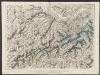
Partie du canton de Berne, du Vallais et canton de Fribourg
1 : 108000 Weiss, Johann Heinrich ; Meyer, Johann Rudolf J. R. Meyer
Carte du canton de Fribourg à l'usage des écoles
1 : 100000 1 Karte dressée en 1851 par Alexandre Stryienski d'après la grande carte topogr. du canton ; gravé par P. Steiner et R. Leuzinger J. Wurster et Comp., Winterthur
Taschen-Atlas der Schweiz
1 Atlas (25 S., 20 Taf.) gezeichnet und gestochen von Emil Wagner = Atlas de poche de la Suisse : 26 cartes en couleurs / dessinées et gravées par Émile Wagner Eggimann, Genf
<<Der>> Canton Freyburg
1 : 270000 1 Karte gez. u. gest. von J.J. Scheurmann [Orell Füssli], [Zürich]
Carte chorographique de la partie occidentale de l'Oberland ou le comté de Gruyéres divisé en quatre bailliages ou gouvernements assavoir Gruyeres, Sanen, Ober Sibenthal et Nider Sibenthal, ou se trouve le gouvernement d'Aigle et le baillaige de Vevay
1 Karte : Kupferdruck ; 54 x 71 cm Loup; Benning s.n.
<<Der>> Canton Freyburg
1 : 270000 1 Karte gez. u. gest. von J.J. Scheurmann [Orell Füssli], [Zürich]

<<Der>> Canton Freyburg
1 : 270000 1 Karte gez. u. gest. von J.J. Scheurmann [Orell Füssli], [Zürich]
Carte de la partie occidentale de l'Oberland au canton de Berne
1 Karte : Kupferdruck ; 31 x 43 cm Clermont; Loup; Perrier; Beauvais; Arrivet Lamy
Atlas Suisse
1 : 120000 16 Karten levé et dessiné par J.H. Weiss [et Joachim Eugen Müller] aux frais de J.R. Meyer à Aarau dans les années 1786 à 1802 ; gravée [sic] par [Christophe] Guérin, [Matthias Gottfried] Eichler et [Johann Jakob] Scheurmann [Johann Rudolf Meyer], Aarau
<<Der>> Canton Freyburg
1 : 270000 1 Karte gez. u. gest. von J.J. Scheurmann [Orell Füssli & Comp.], [Zürich]
Atlas novus Reipublicae Helveticae
1 Atlas ([40] Bl., 97 S.) bey Orell, Gessner und Compagnie, Zürich

Atlas de la Suisse
1 : 450000 1 Atlas (19 Bl.) dessiné par MM. H. Keller, Scheurmann, Pfyffer d'Altishofen, Osterwald, etc. ; gravé par M. Scheurmann Orell Füssli & Co., Zürich
Atlas der alten Eidgenossenschaft in 20 Karten: Kanton Freiburg
Originaltitel: Canton Freiburg sive Pagus Helvetiae Friburgensis cum confinibus. Mit Erklärung der Zeichen. Zeichnung: Walser, Gabriel (1695-1776), reformierter Pfarrer, von Teufen AR Herausgeber: Homännische Erben