Maps of Distretto di Leventina
Geologische Uebersichtskarte der Gotthardbahnstrecke
1 : 25000 Blatt 6 Stapff, Friedrich Moritz [s.n.]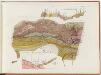
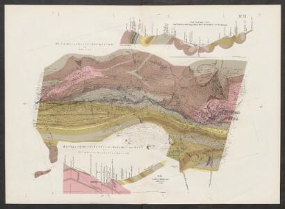
Gotthardbahnstrecke Erstfeld-Castione; geologische Übersichtskarten: Blatt VI: Gebiet Quinto
1 : 25000 Auftraggebung: Direktion der Gotthardbahn Stapff, F. M., einst Vorstand der geologisch-montanistischen Abteilung bei der Zentralbauleitung der Gotthardbahn Berliner lithogr. Institut, Berlin Druck: J. F. Starke, Berlin
[Gotthardbahnlinie]
1 : 5000 3 Karten von F. Becker ; photolithographisch reduziert auf den Massstab 1:5 000 von Brunner & Hauser Brunner & Hauser, Zürich
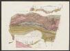
Gotthardbahnstrecke Erstfeld-Castione; geologische Übersichtskarten: Blatt V: Gebiet Airolo
1 : 25000 Auftraggebung: Direktion der Gotthardbahn Stapff, F. M., einst Vorstand der geologisch-montanistischen Abteilung bei der Zentralbauleitung der Gotthardbahn Berliner lithogr. Institut, Berlin Druck: J. F. Starke, Berlin
Geognostische Karte des Sanct Gotthard
1 : 50000 1 Karte aufgenommen in den Jahren 1864, 1865, 1866 u. 1871 durch Karl von Fritsch Wurster, Randegger & Co., Winterthur
Gotthard Gebirge
Geologischer Atlas zur Naturgeschichte der Erde Leonhard, Carl Cäsar von E. Schweizerbart'sche Verlagsbuchhandlung
Rheni, Rhodani Ticini, Ursae prima stamina in sumis alpibus helveticis
1 Karte : Kupferdruck ; 27 x 45 cm Scheuchzer apud I. Cóvens et C. Mortier
Ursae fluvii primi fontes
1 : 66000 1 Karte delineati a Joh. Jacobo Scheuchzer [Verlag nicht ermittelbar], [Erscheinungsort nicht ermittelbar]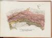
Gotthardbahnstrecke Erstfeld-Castione; geologische Übersichtskarten: Blatt VII: Gebiet Faido
1 : 25000 Auftraggebung: Direktion der Gotthardbahn Stapff, F. M., einst Vorstand der geologisch-montanistischen Abteilung bei der Zentralbauleitung der Gotthardbahn Berliner lithogr. Institut, Berlin Druck: J. F. Starke, Berlin
Ursae fluvii primi fontes
1 : 66000 1 Karte delineati à Joh. Jacobo Scheuchzer excudit Petrus van der Aa, Lugd. Bat. [i.e. Leiden]
Skitourenkarte Gotthard
1 : 50000 Kümmerly & Frey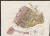
Geologische Uebersichtskarte der Gotthardbahnstrecke
1 : 25000 Blatt 5 Stapff, Friedrich Moritz [s.n.]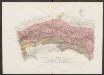
Geologische Uebersichtskarte der Gotthardbahnstrecke
1 : 25000 Blatt 7 Stapff, Friedrich Moritz [s.n.]
Carta geologica del S. Gottardo
1 : 50000 Giordano, F. Borrani
Rheni, Rhodani, Ticini, Ursae, prima stamina in sumis [i.e. summis] alpibus helveticis
1 : 115000 1 Karte delineata a Johanne Jacobo Scheuchzero M.D. excudit Petrus van der Aa, Lugd. Bat.
Generalkarte der Gotthardbahn
1 : 100000 im Verlag von Orell Füssli & Co.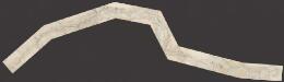
Gotthardbahn: Airolo - Chiasso
1 : 25000 [s.n.]
Canton Uri sive pagus Helvetiae Uriensis cum subditis suis in Valle Lepontina
1 Karte : Kupferdruck ; 45 x 54 cm Walser; Dorn edentibus Homannianis Heredibus
Canton Uri sive pagus Helvetiae Uriensis cum subditis suis in Valle Lepontina
1 Karte : Kupferdruck ; 45 x 54 cm Walser; Dorn edentibus Homannianis Heredibus
Canton Uri
1 : 100000 Müllhaupt, Hans Heinrich Eidg. Stabsbureau
Blatt XIX: Bellinzona, Chiavenna, uit: Topographische Karte der Schweiz / vermessen und hrsg. ... unter Aufsicht des Generals G.H. Dufour
1 : 100000 Annotatie: Met plaatsnamenregister (bl. V), bladwijzer (bl. XXI) en hoogteregister (bl. XXV); Voor aanwezige bladen zie overzichtsblad Dufour, G. H. [Bern : Eidg. Topogr. Bureau]
St. Gotthard
1 Vogelschaukarte Art. Institut Orell Füssli, Zürich
Gotthard
1 : 100000 Eidgenössische Landestopographie
St. Gotthard Gebirge, Theil des Berner Oberlandes und das obere Rhone Thal
Rýn, řeka-tok horní Delkeskamp, F. W. Dauch, J. Ph.
[Malerisches Relief der Schweizer- und angränzenden Alpen]
1 : 135000 11 Vogelschaukarten Nach der Natur aufgenommen und gezeichnet von F.W. Delkeskamp ; gestochen v. Knopfmacher u. J.Ph. Dauch [Friedrich Wilhelm Delkeskamp], [Frankfurt am Main]
Carte der St. Gotthards-Strasse vom Vierwaldstädter See bis an den Tessin
1 : 150000 1 Karte A. Hartmann fec. ; J.J.G. [i.e. Johann Jakob Goll] del. ; Lith. Brupbacher in Wädenschweil bei Heinrich Füssli und Comp., Zürich
Topographische Karte der Schweiz
1 : 100000 25 Karten vermessen und hrsg. auf Befehl der Eidgenössischen Behörden ; aufgenommen unter der Aufsicht des Generals G.H. Dufour Eidg. Topographisches Bureau, [Genève], [später: Bern]
Taschen-Atlas der Schweiz
1 Atlas (25 S., 20 Taf.) gezeichnet und gestochen von Emil Wagner = Atlas de poche de la Suisse : 26 cartes en couleurs / dessinées et gravées par Émile Wagner Eggimann, Genf
Der Canton Ticino
1 : 22200 Ticino (Švýcarsko) Keller, H. Ghiringelli, Paolo